Maps of Nigeria

La Guinee 2.
1 : 9000000 Bonne, Rigobert, 1727-1794
Guinee, Congo.
1 : 15000000 Clouet, J. B. L. (Jean-Baptiste Louis), b. 1730
Tractus littorales Guineæ a Promontorio Verde usque ad sinum Catenbelæ
1 Karte : Kupferdruck ; 49 x 55 cm Renard apud L. Renard
Equatorial West Africa [and] surroundings of Mount Cameroon

Regna Congo et Angola. [Karte], in: Novus atlas absolutissimus, Bd. 6, S. 180.
1 Karte aus Atlas Janssonius Offizin
Aequatorial-West-Afrika
1 : 3000000 Kiepert, Richard ; Sprigade, Paul Geographische Verlagshandlung Dietrich Reimer
West Africa II.
1 : 5600000 Society for the Diffusion of Useful Knowledge (Great Britain)
Carte des découvertis faites dans le centre de l'Afrique
Afrika střední Oudeney Clapperton Gide fils
Sudan, Guinea.
1 : 7250000 Radefeld, Carl Christian Franz, 1788-1874
West Africa.
1 : 2500000 Andree, Richard; Times (London, England)
Neueste Karte von Sudan und Guinea
Grosser Hand-Atlas über alle Theile der Erde in 170 Karten Meyer, J. Verlag des Bibliographischen Instituts
The River Niger.
1 : 3400000 Arrowsmith, John
Western half of Equatorial Africa and the expeditions on land and sea by Henry M. Stanley during 1874-77

Inner-Afrika und der Kongo-Staat
1 : 8000000 Afrika střední Kettler, I. J. Geographisches Institut
Central Africa - western section.
1 : 5000000 John Bartholomew and Son
Spezial - karte von AfricaSekt. Congo (7)
1 : 4000000 1 full d'1 mapa en 10 fulls i estoig Hermann Habenicht; Justus Perthes
Spezial - karte von AfricaSektion Central-Sudân (5)
1 : 4000000 1 full d'1 mapa en 10 fulls i estoig Hermann Habenicht; Justus Perthes
Spezial-Karte von Afrika
1 : 4000000 Blatt 5 Habenicht, Hermann Perthes
Afrique equator.le franc.se
1 : 3000000 Afrika střední Meunier, Alexandre
Carte du réseau fluviale navigable de l'Afrique equatoriale française
1 : 3000000 Afrika střední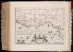
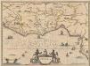
Gvinea
1 : 6550000 Annotatie: Kaart uitg. in de periode ca. 1647-ca. 1657; Origineel is Blad 208 in atlas factice; Annotatie geografische gegevens: Schaalstokken op kaart: 30 Milliaria Germanica communia (=3,5 cm), en: 35 Leucæ Hispanicæ (=3,5 cm) Amstelodami : Sumptibus Joannis Janßonii
Carte géologique de l'Afrique équatoriale Franc[ai]se
1 : 5000000 Afrika střední Barralier, Emmanuel Millet
Spezial-Karte von Afrika
1 : 4000000 Blatt 7 Habenicht, Hermann Perthes
Nieder Guinea, W. Mittel-Africa.
1 : 5500000 Weiland, C. F. (Carl Ferdinand), d. 1847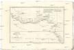
Royaumes, estats et pays de la Haute Guinée
1 : 9600000 Afrika západní Bonne, Rigobert André
Guinea [Karte], in: Gerardi Mercatoris et I. Hondii Newer Atlas, oder, Grosses Weltbuch, Bd. 2, S. 368.
1 Karte aus Atlas Mercator, Gerhard und Hondius, Jodocus Jansson, Jan
GVINEA.
[Amsterdam : Joan Blaeu]
Charte von Nieder Guinea
Angola
CHARTE von NIEDER GUINEA
Angola