Maps of Netherlands
Pays Bas septentrionale.
1 : 1130000 Janvier, Jean
Carte des Provinces unies des Pays Bas : tirée des cartes les plus correcte qui en ont été faites sur les lieux, rectifiées par les observations et opérations géometriques de Snellius et par celles que Mr. Cassini y a faites en dernier lieu
1 : 700000 par G. de l'Isle geographe de l'Academie Royale des Sciences. A Amsterdam : chez Iean Còvens et Corneille Mortier
Carte des Provinces Unies des Pays Bas
1 : 700000 Mollova mapová sbírka Delisle, Guillaume Covens, Johannes I
Novissima et accuratissima XVII provinciarum Germaniae inferioris tabula
1 : 960000 Belgie Danckerts, Justus Munter, Johan ex officina Iusti Danckers
Neue und richtige Land Tafel der XVII. Niederländische Provincien
1 : 1233000 Belgie Sandrart, Jakob von J. Sandrart
Provinces Unies des Pays Bas.
1 : 690000 L'Isle, Guillaume de, 1675-1726
Provinces Unies des Pays Bas.
1 : 690000 L'Isle, Guillaume de, 1675-1726
Holland, Friesland, Groningen, Overyssel, Gelders, Utrecht and Zealand.
1 : 2471040 Carey, Mathew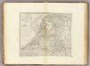
The Seven United Provinces of Holland, Groningen, Gelders, Friesland, Overyssel, Utrecht and Zealand.
1 : 2407680 Carey, Mathew
The Seven United Provinces of Holland, Groningen, Gelders, Friesland, Overyssel, Utrecht and Zealand.
1 : 2407680 Carey, Mathew
The Seven United Provinces of Holland, Groningen, Gelders, Friesland, Overyssel, Utrecht, and Zealand.
1 : 1180000 Melish, John
Carte Des Provinces Unies Des Pays-Bas
1 : 690000 Mollova mapová sbírka Delisle, Guillaume L'Isle, Guillaume de
La republica Battava
1 : 2400000 Nizozemsko Zatta, Antonio Zatta
Descriptio veteris agri Batavi et Frisii omnisque regionis quae hodie est in dicione VII. Foederatorum cis et ultra Rhenum
1 : 950000 auctore Mensone Alting. [Amstelaedami] : [apud Henricum Wetstenium]
Algemeene kaart der Vereenigde Nederlanden : getrokken uyt de aller naauwkeurigsten kaarten, opde plaatsen selve gemaakt, en geschikt volgens de beste en nieuwste waarnemingen en aanteekeningen.
1 : 1000000 Zacharias Châtelain t' Amsterdam : by Zacharias Châtelain
Carte des XVII. Provinces des Pays Bas
1 : 640000 Mollova mapová sbírka Inselin, Charles Jaillot, Alexis Hubert
Les Dix-Sept Provinces Des Pays-Bas
1 : 760000 Mollova mapová sbírka Sanson, Guillaume Sanson, Guillaume
XVII PROVINCIAE BELGII accurate delineatae
Belgie
Belgii Veteris Typvs
1 : 1375000 Mollova mapová sbírka Ortelius, Abraham Ortelius, Abraham
Holland or the United Provinces.
from A new systeme of the mathematicks: containing I. Arithmetick, as well natural and decimal, as in species, or the principles of algebra. II. Practical geometry, together with the first six books of Euclid's Elements, as also the eleventh and twelfth, symbo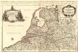
Provinces-Unies des Pays-Bas
1 : 625000 Mollova mapová sbírka Sanson, Guillaume Jaillot, Alexis Hubert
Belgique, Hollande.
1 : 1000000 Lapie, M. (Pierre), 1779-1850
Republik der Vereinigten Niederlande Innerer Aufbau 1648
Niederlande Verwaltungsgliederung Kunz, Andreas ; Moeschl, Joachim Robert
Provinces-Unies des Pays-Bas : avec leurs acquisitions dans la Flandre, le Brabant, le Limbourg et le Lyege
1 : 700000 par le Sr. Sanson, Géographe ordinaire du Roy Cordier, sculp. Paris : H. Jaillot
Hollanda
[Giralomo Porro] [Venetië] : Simon Galignani ; Giralomo Porro]
Novissima et accuratissima XVII provinciarum Germaniae inferioris delineatio
1 : 897000 Belgie Visscher, Nicolaes Jansz. ex officina Nicolai Visscher
Novissima et accuratissima XVII provinciarum Germaniae inferioris tabula
1 : 800000 1 Karte : Kupferdruck ; 47 x 54 cm Danckerts, Justus [Danckerts]
Carte des Provinces Unies des Pays Bas
1 : 1000000 Mollova mapová sbírka Chatelain, Zacharias Chatelain, Zacharias II
Postkarte von dem Vereinigten Niederlanden
Belgie Stenger, Johann im von Reillyschen Landkarten und Kunstwerke Verschleiss Komptoir