Maps of Greenwich

Maps of Greenwich

$title$

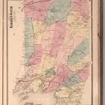
Town of Greenwich, Fairfield County, Connecticut.

1 : 38169 Beers, Frederick W.
$title$

8 Greenwich.

1 : 18000 Hyde & Company
$title$

Glenville

1 : 24000
$title$

Glenville

1 : 24000
$title$

Glenville

1 : 24000
$title$

Glenville

1 : 24000
$title$

Glenville

1 : 31680
$title$

Glenville

1 : 24000
$title$

Glenville

1 : 24000
$title$

Glenville

1 : 24000
$title$

10 Atlas rural country district north of New York City.

1 : 18000 Hyde, E. Belcher
$title$

5. Larchmont-Kensico Sta.-Hartsdale-Greenwich.

1 : 80000 Servoss, R. D.
$title$

N. Castle, Town.

1 : 47520 Beers, F. W. (Frederick W.)
$title$

North Castle town.

1 : 31680 Bien, Joseph Rudolf
$title$

5. Larchmont-Kensico Sta.-Hartsdale-Greenwich.

1 : 80000 Servoss, R. D.
$title$

Stamford

1 : 24000
$title$

Stamford

1 : 24000
$title$

Stamford

1 : 24000
$title$

Harrison, Rye towns.

1 : 31680 Beers, F. W. (Frederick W.)
$title$

Town of Rye, Westerchester Co. N.Y.

from County atlas of Westchester, New York. Published by J.B. Beers & Co., assisted by S.W. Wilson and others.
$title$

White Plains, Harrison, Rye towns.

1 : 27600 Bien, Joseph Rudolf
$title$

7 Atlas rural country district north of New York City.

1 : 13000 Hyde, E. Belcher
$title$

5 Atlas rural country district north of New York City.

1 : 13000 Hyde, E. Belcher
$title$

242-243 North Castle.

1 : 21600 G.W. Bromley & Co.
$title$

Westchester, V. 1, Double Page Plate No. 35 [Map bounded by Town of Rye, Village of Port Chester, Long Island Sound, Apawamis Ave., North St., Town of Harrison]

From Vol. 1
$title$

Plate 14: Vol. 3 of Maps, Page 10. [Bounded by Old Road, Road to Hunt's Point and (Homestead Farms of Thos. Leggett) Leggetts Creek.] - Vol 2. of Maps, Page 28. [Bounded by Bronx River, The Hunt's Point Road and The Westchester Turnpike Road.]

from Certified copies of important maps appertaining to the 23rd and 24th wards, City of New York, filed in the Register's office at White Plains, County of Westchester, New York ...
$title$

248-249 New Castle, North Castle.

1 : 21600 G.W. Bromley & Co.
$title$

4 Atlas rural country district north of New York City.

1 : 13000 Hyde, E. Belcher
$title$

Westchester, Double Page Plate No. 19 [Map bounded by Regent St., Connecticut] / prepared under the direction of Joseph R. Bien, from general surveys and official records.

From Atlas of Westchester County, New York
$title$

264-265 Harrison, Rye.

1 : 14400 G.W. Bromley & Co.
© MapTiler © OpenStreetMap contributors
How does it work?
These instructions will show you how to find historical maps online.
Getting started
Type the place name in the search box to find the exact location. You can further adjust the search by zooming in and out.
Zoom
Zoom in and out with the buttons or use your mouse or touchpad natively.
Exact Area tool
Click here and draw a rectangle over the map to precisely define the search area.
Set filters
Narrow your search with advanced settings, such as Years (from/to), Fulltext, Publisher, etc.
Results
See the results of your search on the right side. You can scroll down to find more maps of this location.
?

Download OldMapsOnline Mobile