Maps of Bronx County

Maps of Bronx County

$title$

Plans of Westchester, West Farms, Morrisania, Westchester County and Part of New York County. New York.
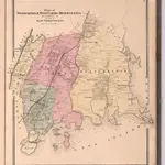
1 : 42240 Beers, Frederick W.
$title$

New Standard map of the Borough of Bronx.

From Bronx
$title$

1 Bronx.

1 : 18000 Hyde & Company
$title$

Map or plan showing the system of streets, avenues, public squares and places, parks, bridges, etc. in that part of the borough of the Bronx, City of New York lying easterly of the Bronx River.

From Bronx
$title$

2. Harlem-Yonkers-Pelham Manor.

1 : 80000 Servoss, R. D.
$title$

Index to Volume Two: Atlas of the Borough of the Bronx, City of New York. Part of 24th Ward.

from Atlas of the borough of the Bronx, city of New York : based upon official plans and maps on file in the various city offices; supplemented by careful field measurements and personal observations, by and under the supervision of Hugo Ullitz.
$title$

Plate 50: Town of Westchester, Westchester Co. N.Y.

from County atlas of Westchester, New York. Published by J.B. Beers & Co., assisted by S.W. Wilson and others.
$title$

Morrisania, Westchester Co. N.Y.

from County atlas of Westchester, New York. Published by J.B. Beers & Co., assisted by S.W. Wilson and others.
$title$

Plates 21 & 22: Town and City of Yonkers, Westchester Co. N.Y. - Town of East Chester, Westchester Co. N.Y.

From County atlas of Westchester, New York. Published by J.B. Beers & Co., assisted by S.W. Wilson and others.
$title$

[Map of the city of New York and island of Manhattan as laid out by the commissioners appointed by the Legislature, April 3, 1807]

From Manhattan
$title$

Outline and Index Map of the 23rd Ward, City of New York.

from Atlas of the city of New York : from official records, private plans & actual surveys / compiled under the supervision of E. Robinson & R. H. Pidgeon.
$title$

Topographical atlas of the city of New York, including the annexed territory showing original water courses and made land. / prepared under the direction of Egbert L. Viele.

From Topographical atlas of the city of New York, including the annexed territory showing original water courses and made land
$title$

Outline and Index Map, Sections 9 and 10, Borough of the Bronx.

from Atlas and owners names, borough of the Bronx, sections 9 & 10 : from actual surveys and official plans / by George W. and Walter S. Bromley.
$title$

Hammods Atlas of New York City and the metropolitan district

$title$

Hammods Atlas of New York City and the metropolitan district

$title$

W. Farms, Morrisania.

1 : 15840 Beers, F. W. (Frederick W.)
$title$

From New York to Stratford. (2)

1 : 35000 Colles, Christopher
$title$

Westchester, Pelham towns.

1 : 21120 Bien, Joseph Rudolf
$title$

Topographical atlas of the city of New York, including the annexed territory showing original water courses and made land. / prepared under the direction of Egbert L. Viele.

From Topographical atlas of the city of New York, including the annexed territory showing original water courses and made land
$title$

Use District Map Section No. 6

from Use district map / City of New York, Board of Estimate and Apportionment.
$title$

Area District Map Section No. 4

from Area district map / City of New York, Board of Estimate and Apportionment.
$title$

Area District Map Section No. 7

from Area district map / City of New York, Board of Estimate and Apportionment.
$title$

Riderdale, Fieldston, Kingsbridge, North Riverdale, Spuyten Duyvil

From District 14
$title$

Part of Ward 24, New York City.

from Atlas of the city of New York : embracing all territory within its corporate limits from official records, private plans & actual surveys / by and under the supervision of E. Robinson & R.H. Pidgeon, civil engineers.
$title$

Plate 83, Part of Section 13, Borough of the Bronx. [Bounded by Webster Avenue, Bronx Boulevard, White Plains Road, E. 180th Street, Boston Road, E. 188th Street, Southern Boulevard and E. Fordham Road.]

from Atlas of borough of the Bronx, Sections 9 10 11 12 & 13 : from actual surveys and official plans / G.W. Bromley and Co.
$title$

Area District Map Section No. 6; Area district map / City of New York, Board of Estimate and Apportionment.

from Area district map / City of New York, Board of Estimate and Apportionment. New York (N.Y.). Board of Estimate and Apportionment,
$title$

Height District Map Section No. 6; Height district map / City of New York, Board of Estimate and Apportionment.

from Height district map / City of New York, Board of Estimate and Apportionment. New York (N.Y.). Board of Estimate and Apportionment,
$title$

Use District Map Section No. 3; Use district map / City of New York, Board of Estimate and Apportionment.

from Use district map / City of New York, Board of Estimate and Apportionment. New York (N.Y.). Board of Estimate and Apportionment,
$title$

Height District Map Section No. 3; Height district map / City of New York, Board of Estimate and Apportionment.

from Height district map / City of New York, Board of Estimate and Apportionment. New York (N.Y.). Board of Estimate and Apportionment,
$title$

Area District Map Section No. 3; Area district map / City of New York, Board of Estimate and Apportionment.

from Area district map / City of New York, Board of Estimate and Apportionment. New York (N.Y.). Board of Estimate and Apportionment,
© MapTiler © OpenStreetMap contributors
How does it work?
These instructions will show you how to find historical maps online.
Getting started
Type the place name in the search box to find the exact location. You can further adjust the search by zooming in and out.
Zoom
Zoom in and out with the buttons or use your mouse or touchpad natively.
Exact Area tool
Click here and draw a rectangle over the map to precisely define the search area.
Set filters
Narrow your search with advanced settings, such as Years (from/to), Fulltext, Publisher, etc.
Results
See the results of your search on the right side. You can scroll down to find more maps of this location.
?

Download OldMapsOnline Mobile