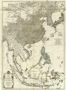
Maps of China

Asie 2.
1 : 7150000 Anville, Jean Baptiste Bourguignon d, 1697-1782
Java-China-Japan Lyn / specially prep. by Edward Stanford Ltd.
1 : 6969600 Annotatie: Met afstandentabel (in zeemijlen) Stanford's Geographical Establishment, Londen London : Stanford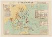
太平洋戰爭日本陸軍戰力喪失一覽圖
1 : 15000000 太平洋戰爭日本陸軍戰力喪失一覽圖 昭和二十二年[1947]4月30日,植野錄夫 编辑,东京:日本地圖株式會社发行。 此图反映了二战反攻阶段东亚、东南亚和太平洋地区盟军与日军的战斗形势,包括东北苏军进攻路线、中国本部反攻路线、东南亚和太平洋诸岛美军进攻路线等。图中用蓝色标注了此时日军在中国、东南亚及本岛的军队部署及战争损失统计。附表罗列自1937年以来日本历次战争的名称、时间、参战部队及军力损失。另有《飛行機生産表》,显示日军战机的生产配备情况。 附插图1幅:《内地戰災被害状況圖》。 1图,彩色,日文,图幅61 x 86 cm,比例尺1:15,000,000,经纬度E80°-W160°;S10°-N55°。 Harvard-Yenching | Manchuguo J-0827;Hollis Number:014623825 植野錄夫 日本地圖株式會社
Atlas für Industrie- und Handelsgeographie: Für commercielle und technische Lehranstalten, für Kaufleute und Industrielle

Far East, Mediterranean Area.
1 : 13000000 Sun Oil Company
Indes, la Chine.
1 : 10700000 L'Isle, Guillaume de, 1675-1726
Indes, la Chine.
1 : 10700000 L'Isle, Guillaume de, 1675-1726
Indien und Ostasien
1 : 10000000 Asie východní Verlagsanstalt List & von Bressensdorf
Ostasiatischer-Raum
1 : 10000000 Asie východní Bibliographisches Institut
Ost-Asien / Neubearb. von Richard Kiepert und Paul Sprigade
1 : 12000000 Richard Kiepert 1846-1915; Paul Sprigade Berlin : Dietrich Reimer (Ernst Vohsen)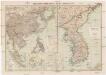
Russisch-Japanischer Kriegsschauplatz
1 : 12000000 Japonsko Kiepert, Richard Sprigade, Paul Dietrich Reimer
World War II Maps.
Hammond, C.S.
Ost-Asien
1 : 12000000 Asie východní Kiepert, Richard Sprigade, Paul Geographische Verlagshandlung Dietrich Reimer (Ernst Vohsen)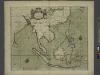
A chart of the eastermost part of the EAST INDIES and CHINA, from cape comarine to IAPAN, with all adjacent Islands
from The sea-atlas : containing an hydrographical description of most of the sea-coasts of the known parts of the world.
Chinae, olim Sinarum regionis, nova descriptio. [Karte], in: Theatrum orbis terrarum, S. 298.
1 Karte aus Atlas Ortelius, Abraham
[Indischer Ozean, östlicher Teil]
1 Karte : Kupferdruck ; 57 x 45 cm Doncker Hendrik Doncker
Ost-Asien
Neuer Handatlas über alle Theile der Erde Kiepert, Heinrich Verlag von Dietrich Reimer
Charte von China und den angränzenden Ländern, und Völkerschaften so wie dem letzten Kaiser Tschien-Long unterworfen waren
1 : 47500000 Asie jihovýchodní Macartney, George Macartney
Charte von China und den angränzenden Ländern, und Völkerschaften so wie dem letzten Kaiser Tschien-Long unterworfen waren
1 : 47500000 Asie jihovýchodní Macartney, George Macartney
CHARTE von CHINA und den angränzenden Ländern, und Völkerschaften so wie sie dem letzten Kaiser Tschien-Long unterworfen waren
1 : 47500000 Asie jihovýchodní Macartney, George Macartney
Chinae, olim Sinarum regionis, nova descriptio. [Karte], in: Theatrum orbis terrarum, S. 393.
1 Karte aus Atlas Ortelius, Abraham Vrients, Jan Baptista
Map of China, Burma, Siam, Annam & c
1 : 10280000 Hongkong (Čína) G.W. Bacon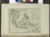
The islands of the East Indies with the channels between India, China & New Holland.
from Carey's general atlas, improved and enlarged : being a collection of maps of the world and quarters, their principal empires, kingdoms, &c.
South Eastern Asia.
1 : 16600000 Sharpe, J.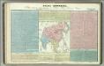
Tableau l'historie de L'Asie, Inde, Chine, Japon.
1 : 33200000 Duval, Henri
Das Chinesische Reich mit seinen Schutzstaaten
Grosser Hand-Atlas über alle Theile der Erde in 170 Karten Meyer, J. Verlag des Bibliographischen Instituts

[139][142] Orientaliora Indiarum orientalium ... Pascaert ... van Oost Indien, uit: Atlas sive Descriptio terrarum orbis
Annotatie: Gedigitaliseerde versie. Amsterdam. Heiloo : Picturae (vervaardiger), 2015. tiff-bestand. Gedigitaliseerd: 07-01-2015; Origineel: Universiteitsbibliotheek Vrije Universiteit (XL.05127.-) ; Netherlands; Titelpagina ontbreekt Wit, Frederik de Amsterdam : Frederick de Wit
Ostindien und China
E. von Sydow's Schul-Atlas in sechs und dreissig Karten Sydow, Emil von bei Justus Perthes