Maps of Pontic Steppe

Europe 3.
1 : 2800000 Anville, Jean Baptiste Bourguignon d, 1697-1782
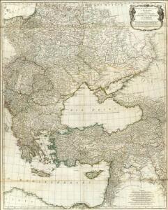
Turkey, in Europe and Hungary, from the best authorities.
from Carey's general atlas, improved and enlarged : being a collection of maps of the world and quarters, their principal empires, kingdoms, &c.
Střední Evropa a Přední Asie za časů III. války křížové

Russland um das Jahr 962
1 : 21000000 Russland
Ost- und Mitteleuropa i.d. zweiten Hälfte d. 18. Jahrhunderts. Die polnischen Teilungen
1 : 12000000 Polen-Litauen, Ostmitteleuropa, Teilungen Polens
Eastern Europe - communications.
1 : 5300000 John Bartholomew and Son
Südeuropa
1 : 2500000 Blízký východ Gea Verlag
Imperium Romanum
1 : 11300000 Evropa východní Bonne, Rigobert André
Esquisse d’une marche générale des Slaves, du pays des Sauromates vers l’Occident et le Nord-Ouest de l’Europe, du 5e siècle avant notre ère jusqu’au 8e siècle de notre ère
Europa Sarmaten Slawen Völkerwanderungszeit
Schauplatz des russisch-türkischen Krieges
1 : 2850000 Evropa východní Anville, Jean-Baptiste Bourguinon d' Schraembl, Franz Anton F. A. Schraembl
Schauplatz des Russisch Türkischen Krieges
1 : 2850000 Evropa východní Anville, Jean-Baptiste Bourguinon d' Schraembl, Franz Anton F. A. Schraembl
Schauplatz des Russisch Türkischen Krieges
1 : 2850000 Balkánský poloostrov Anville, Jean-Baptiste Bourguinon d' Schraembl, Franz Anton F.A. Schraembl
Schauplatz des russisch-türkischen Krieges
1 : 2850000 Evropa východní Anville, Jean-Baptiste Bourguinon d' Schraembl, Franz Anton F. A. Schraembl
A new map of Turky in Europe and parts adjoyning shewing their principal divisions and chief cities, towns, rivers, mountains &c.
from A new sett of maps both of antient and present geography : wherein not only the latitude and longitude of many places are corrected according to the latest observations, but also the most remarkable differences of antient and present geography may be quickly discern'd by a bare inspection or comparing of correspondent maps, which seems to be the most natural and easy method to lead young students (for whose use the work is principally intended) unto a competent knowledge of the geographical science : together with a geographical treatise particularly adapted to the use and design of these maps / by Edward Wells, M.A. and student of Christ-Church, Oxon.
[Ethnographische Karte von Europa]
Zweiter Band, enthaltend in vier Abtheilungen die Vertheilung der Organismen: 5. Pflanzen-Geographie, 6. Thier-Geographie, 7. Anthropographie, 8. Ethnographie Humboldt, Alexander von Verlag von Justus Perthes
Carte du teatre de la guerre dans la Pologne, Moscovie & Turquie
1 : 3250000 Evropa jihovýchodní Visscher, Nicolaus Schenk, Pieter apud Petrum Schenk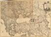
Le Theatre de la Guerre entre les deux puissans Empires de Russie et de Turquie, tant en Europe qu'en Asie :
1 : 2200000 Mollova mapová sbírka Jaeger, Johann Wilhelm Abraham Facius, Johann Gottlieb Jäger, Johann Wilhelm Abraham
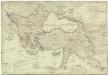
Eastern part of the mediterranean sea with the coasts of Turky Anatolia Syria Egypt and Barbary
1 Blatt : 53 x 68 cm Sayer
Balkánské státy a Turecko
1 : 3000000 Bospor (Turecko : průliv) Paulík, Ant. Klus, František Ústřední učitelské nakladatelství a knihkupectví
Imperii Romani distracta
1 : 55500000 Asie západní Bonne, Rigobert André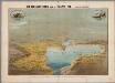
Het oorlogsterrein aan de Zwarte Zee : (vogelperspectief)
Annotatie: Onder de kaart: De toeschouwer stelle zich geplaatst te zijn 300 k.m. boven den Hellespont met het gezicht naar het Noord-Oosten Arnhem : Van Egmond & Heuvelink
Partie orient.le de la mer Méditerranée
1 Karte : Kupferdruck ; 49 x 55 cm Robert de Vaugondy chés l'auteur quay de l'horloge du Palais près le pont neuf
L'Empire Grec en 1190 et l'Hellenisme pendant l'occupation latine de Constantinople [Hauptkarte]
Byzantinisches Reich Lateinisches Kaiserreich Konstantinopel Hellenismus Kümmerly & Frey
Carte Nouvelle du Royaume de Pologne
Mollova mapová sbírka Bonne, Rigobert Lotter, Matthaus Albrecht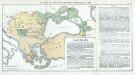
Nr. 12. Der Verfall der Türkei und die griechischen Freiheitskämpfe bis 1829
Osmanisches Reich Griechischer Unabhängigkeitskrieg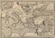
Argonautica. [Karte] [Europa.], [Thessalia und Umgebung], [Hellespontus, Phryxeum aequor, et Athamantidis fluenta.] [3 Nebenkarten], in: Theatrum orbis terrarum, S. 538.
1 Karte aus Atlas Ortelius, Abraham Vrients, Jan Baptista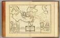
Nouveau Testament, regions, lieux.
1 : 10200000 Bonne, Rigobert, 1727-1794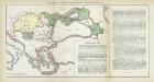
Nr. 8. Der Verfall der Türkei und die griechischen Freiheitskämpfe bis 1829
Osmanisches Reich Griechischer Unabhängigkeitskrieg
Turkish Empire, Greece.
1 : 7200000 Society for the Diffusion of Useful Knowledge (Great Britain)