Maps of Carpathian Mountains

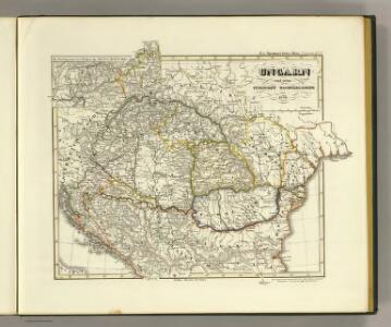
Ungarn und seine sudlichen Nachbarlander seit 1526.
1 : 3800000 Spruner von Merz, Karl
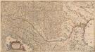
Le royaume de Hongrie
1 : 260000 Uhersko Delisle, Guillaume Covens et Mortier
Karpatenländer, politische Übersicht
1 : 6000000 Donau-Karpaten-Gebiet
Karpatenländer, Flusz- & Gebirgskarte
1 : 6000000 Donau-Karpaten-Gebiet
Le Royaume de Hongrie et des pays qui en dependoient autrefois ; Nova et accurata Regni Hungariae tabula, ad usum serenissimi Burgundiae ducis
Ungarn, Osmanisches Reich L'Isle, Guillaume de
Galizien, Ungarn mit Sclavonien und Croatien, Siebenbürgen und Dalmatien; Moldau, Walachey]
Stieler's Hand-Atlas Stieler, Adolf bei Justus Perthes
Nieuwe kaart van Hongarien en het noordelyke deel van Turkyen
1 : 5000000 [S.l.] : [s.n.]
Ungarn und seine Nebenlande bis zum Aussterben Arpadischen Stammers 1301.
1 : 3800000 Spruner von Merz, Karl
[Galizien, Ungarn Slavonien und Croatien, Siebenbürgen und Dalmatien, Moldau, Wallachey]
Hand-Atlas über alle Theile der Erde nach dem neuesten Zustande und über das Weltgebäude Stieler, Adolf bei Justus Perthes
Le Royaume de Hongrie...

Tabula Hungaria et regionum, quae praeterea ab ea dependent
1 : 2100000 Maďarsko Delisle, Guillaume Lotter, Georg F. T. C. Lotter
Totius Regni Hungariae maximaeque partis Danubii fluminis, una cum adjacentibus et finitimis regionibus novissima delineatio / per Nicolaum Visscher
1 : 2000000 Annotatie: Origineel is Blad 130 in atlas factice; Annotatie geografische gegevens: Met 2 schaalstokken Nicolaes Jansz. Visscher jr. 1649-1702 [Amsterdam : per Nicolaum Visscher]
Accurate Landkarte die Königreiche Ober- und Nieder- Hungarn, Slavonien, Croatien, Dalmatien, Bosnien, Servien, Bulgarien, und Romanien, das Groß Fürstenthum Siebenbürgen, die Fürstenthümer Moldau, Wallachen, Bessarabien, die Oczakowisch- und Crimische Tartaren, die pohlnische Provinz Podolien, wie auch ein Theil von Ukranien, und übrige angränzende Ländern vorstellend
1 : 1430000 Besarábie (Moldavsko a Ukrajina) Lidl, Johann Jakob Joh. Jacob Lidl
Galizien, Ungarn mit Slavonien und Croatien, Siebenbürgen und Dalmatien, Moldau, Wallachey
1 : 3700000 Chorvatsko Justus Perthes
Le Royaume de Hongrie et les estats qui en esté sujets et qui sont presentement la partie septentrionale de la Turquie en Europe. Tiré des memoires les plus nouveaux
1 : 2100000 Ungarn, Südosteuropa Sanson, Guillaume

Karpaten-Länder
Donau-Karpaten-Gebiet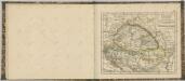
Totius Regni Hungariae, Maximaeque Partis Danubii Fluminis, una cum adjacentibus et finitimis Regionibus Novissima Delineatio [Karte], in: Novus atlas absolutissimus, Bd. 2, S. 293.
1 Karte aus Atlas Janssonius Offizin
Ungarn und seine Nebenlande nach ihrer kirchlichen Eintheilung bis in das XVte. Jahrhundert.
1 : 3800000 Spruner von Merz, Karl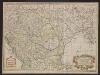
Carte de la Hongrie et partie septentrionale de la Turquie
Ungarn, Osmanisches Reich L'Isle, Guillaume de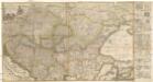
Accurate Landkarte die Königreiche Ober- und Nieder- Hungarn, Slavonien, Croatien, Dalmatien, Bosnien, Servien, Bulgarien und Romanien, das Gross Fürstenthum Siebenbürgen, die Fürstenthümer Moldau, Wallachen, Bessarabien, die Oczakowisch- und Crimische Tartaren, die Pohlnische Provinz Podolien, wie auch ein Theil von Ukranien, und übrige angränzende Ländere vorstellend
1 : 1430000 Besarábie (Moldavsko a Ukrajina) Lidl, Johann Jakob Joh. Jacob Lidl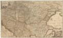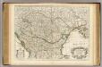
Hongrie, pays qui en dependoient autrefois.
1 : 2550000 L'Isle, Guillaume de, 1675-1726
Hungariae ampliori significatu...

Die Laender an der untern Donau Vten.-Xte. Jahrhundert.
1 : 3800000 Spruner von Merz, Karl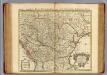
Hongrie.
1 : 2550000 L'Isle, Guillaume de, 1675-1726
Tabula Hungaria et regionum, quae praeterea ab ea dependent, delineata juxta magnum numerum an[n]otationum et mappas manuscriptas vel impressas
1 : 2600000 Evropa jihovýchodní Delisle, Guillaume Lotter, Georg F. Tob. Conr. Lotter
Tabula Hungaria et regionum, quae praeterea ab ea dependent, delineata juxta magnum numerum an[n]otationum et mappas manuscriptas vel impressas
1 : 2600000 Evropa jihovýchodní Delisle, Guillaume Lotter, Georg F. Tob. Conr. Lotter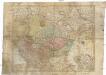
Tabula Hungaria et regionum, quae praeterea ab ea dependent, delineata juxta magnum numerum an[n]otationum et mappas manuscriptas vel impressas
1 : 2600000 Evropa jihovýchodní Delisle, Guillaume Lotter, Georg F. Tob. Conr. Lotter
Tabula Hungaria et regionum, quae praaeterea ab ea dependent, delineata juxta magnum numerum an[n]otatium et mappas manuscriptas vel impressas
1 : 2300000 Maďarsko Delisle, Guillaume Lotter, Georg F. T. C. Lotter