Maps of Spain

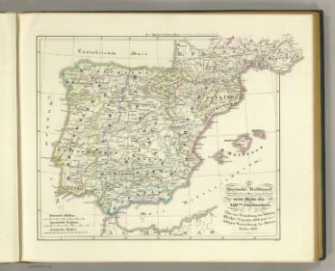
Die iberische Halbinsel bis in die Mitte des XIIIten Jahrhundert's.
1 : 3800000 Spruner von Merz, Karl
Tabula Moderna Hispanie [Karte], in: [Clavdii Ptholomei Cosmographi ...], S. 251.
1 Karte aus Atlas Nicolaus Germanus [und Ptolemaeus, Claudius]
Hispania III. Nova Tabula [Karte], in: Claud. Ptolemaeus. Geographia lat. cum mappis [...], S. 338.
1 Karte aus Atlas Münster, Sebastian [und Ptolemaeus, Claudius]
Carte administrative, physique et routiere de l'Espagne et du Portugal indiquant les canaux, les rivieres naviables, les routes de poste et les nouvelles divisions des provinces, &c.
1 Mapa, col. Orla amb 32 vistes de ciutats i monuments. - Limits acolorits Dufour, A.-H. Dufour, Bulla et Jouy
Hispania III. Nova Tabula [Karte], in: Geographia universalis vetus et nova complectens Claudii Ptolemaei Alexandrini enarrationis libros VIII, S. 308.
1 Karte aus Atlas Münster, Sebastian [und Ptolemaeus, Claudius]
Emirat von Cordoba bis zum Untergange der Ommijaden; christlichen Reiche im Norden der iberischen Halbinsel 711 bis 1028.
1 : 3700000 Spruner von Merz, Karl
Carta itineraria de España
1 : 1500000 Depósito Central de Planos de la Dirección General de Obras Públicas
L'Espagne divisée en tous ses Royaumes Et Principautés [...] [Karte], in: Atlas nouveau, contenant toutes les parties du monde [...], Bd. 2, S. 107.
1 Karte aus Atlas Sanson, Nicolas Jaillot, Alexis Hubert und Mortier, Pieter
Hispania
1 Karte : Kupferdruck ; 48 x 55 cm L'Isle; Seutter; Silva Matthäus Seutter
[Spanien und Portugal, Iberische Halbinsel]
Geographischer Atlas über alle Theile der Erde Ziegler, Jakob Melchior Verlag von Dietrich Reimer
REGNORUM HISPANIAE et PORTUGALLIAE Tabula generalis
1 : 2700000 Aragonie (Španělsko) Homann, Johann Baptist Delisle, Guillaume a Ioh. Bapt. Homanno
REGNORUM HISPANIAE et PORTUGALLIAE Tabula generalis
1 : 2700000 Aragonie (Španělsko) Homann, Johann Baptist Delisle, Guillaume a Ioh. Bapt. Homanno
Hispaniae Veteris Descriptio. [Karte], in: Theatrum orbis terrarum, S. 459.
1 Karte aus Atlas Ortelius, Abraham Vrients, Jan Baptista
Hispaniae Veteris Descriptio. [Karte] [Blastophoenices, Region Cádiz] [Nebenkarte], in: Theatrum orbis terrarum, S. 368.
1 Karte aus Atlas Ortelius, Abraham
Coasts Spain, Portugal, Barbary.
1 : 3200000 Faden, William, 1750?-1836
A new & exact map of Spain and Portugal, divided into its kingdoms and principalities &c. ...
from The world described, or, A new and correct sett of maps : shewing the kingdoms and states in all the known parts of the earth, with the principal cities, and most considerable towns in the world ... / ... by Herman Moll, geographer ...
España: comunicaciones terrestres
Datat al 1950 aproximadament. 0 Seix y Barral
Hispaniae Veteris Descriptio.[Karte] [Iulia Gaditana Aug. und Umgebung] [Nebenkarte], in: Gerardi Mercatoris et I. Hondii Newer Atlas, oder, Grosses Weltbuch, Bd. 2, S. 207.
1 Karte aus Atlas Mercator, Gerhard und Hondius, Jodocus Jansson, Jan
Hispaniae Veteris Descriptio. [Karte] [Iulia Gaditana Aug. und Umgebung] [Nebenkarte], in: Novus atlas absolutissimus, Bd. 6, S. 8.
1 Karte aus Atlas Janssonius Offizin
Carte générale de l'Espagne et du Portugal / par A.H. Brué
1 Mapa. Atlas universel; 22 Brué. Adrien-Hubert chez l'auteur et chez Simonneau
Mapa general de España antigua
1 Karte : Kupferdruck ; 33 x 38 cm López se hallarà con todàs las obras del autor y las de su padre
Regnorum Hispaniae nova descriptio
1 mapa, col.. Text: francès. Reclam: A, 1. - Originàriament dins: Le Theatre du monde ou novvel atlas, mis en lumiere par Gvillavme & Iean Blaeu. Amsterdam, 1643. Blaeu, Willem Jansz.; Blaeu, Joan mis en lumiere par Gvillavme & Iean Blaeu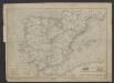
Mapa de la guia oficial de ferro-carriles de España, Francia y Portugal
1 : 4000000 Ferreiro, Martin 1830-1896
Portugal et Hispania : ex archetypo Roderici Mendez Silvae et variis relationibus et chartis manu scriptis et impressis huius Regni rectificatis per Observationes Sociorum Academiae Scieiniarum quae est Parisiis
1 : 3200000 per G. de L'Isle Aug. Vind : in officina Tobiae Conr. Lotter
Hispania : ex archetypo Roderici Mendez Silvae et variis relationibus et chartis manu scriptis et impressis hujus regni rectificatis per Observationes Sociorum Academiae Scientiarum quae est Parisiis
1 : 3200000 per G. De L'Isle Matth. Seutter sculp. Aug. Vind : in officina Tobiae Conr. Lotter
Spanien und Portugal
E. von Sydow's Schul-Atlas in sechs und dreissig Karten Sydow, Emil von bei Justus Perthes
Mapa general de España Antiqua, dividido en tres partes, Bética, Lusitánia y Tarraconénse, con la subdivision de cada una
1 : 3700000 por [...] Juan Lopez, pensionista de S.M [...] Madrid : [Thomas Lopez]