Maps of Mys Shmidta

Grossbritannien's saemmtliche Besitzungen mit Angabe ihrer Erwerbungszeit.
1 : 97000000 Spruner von Merz, Karl
Mappemonde aux la projection de Mercator.
1 : 89000000 Picquet, C.
The World on Mercator's Projection.
1 : 100000000 Hughes, William
Mappemonde, sur l'horizon de Paris; Mappemonde sur la projection polaire.
1 : 120000000 Picquet, C.
World, Moravia missions.
1 : 210000000 Peterson, Augusts
Regions Polaires
Vivien St Martin, L.
Forest Trees, Useful Plants, and Minerals.
1 : 100000000 Johnson, A.J.
World on Mercator's Projection.
1 : 65000000 Asher & Adams
World in Hemispheres.
1 : 72000000 Johnston, Alexander Keith
Planisphere.
1 : 82000000 Jouvet et Cie.
The World.
1 : 110000000 Hughes, William
Mappe -Monde en deux Hemispheres.
1 : 95000000 Vivien de St Martin, L.
Grund u. Boden.
1 : 90000000 Rohrbach, C.
248-249. Arctic, Antarctic. The World Atlas.
1 : 20000000 USSR (Union of Soviet Socialist Republics).
Ice Chart, Northern Hemisphere, July.
U.S. Navy
Ice Chart, Northern Hemisphere, December.
U.S. Navy
River Ice in Relation to Navigation, Closing Dates.
U.S. Navy
Ice Chart, Northern Hemisphere, November.
U.S. Navy
Gareloi Island
1 : 250000
Gareloi Island
1 : 250000
Gareloi Island
1 : 250000
Gareloi Island
1 : 250000
Gareloi Island
1 : 250000
Gareloi Island
1 : 250000
Gareloi Island
1 : 250000
World Physical Features. Ocean Currents. Ethnographic Chart of the World.
Hughes, William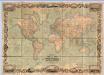
World on Mercator's Projection.
1 : 15000000 Johnson, D. Griffing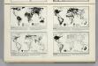
Accessibility. Religions. Occupations. Language.
Hammond, C.S.
Population. Political Associations. Minerals. Crops.
Hammond, C.S.