Maps of Bronx County
39. Ward 24.
1 : 7200 G.W. Bromley & Co.; Geo. W. Bromley & E. Robinson
1D - N.Y. City (Aerial Set).
from Sectional aerial maps of the City of New York / [photographed and assembled under the direction of the chief engineer, July 1st, 1924].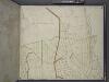
Bronx, Topographical Map Sheet 4; [Map bounded by Mosholu Ave., Jerome Ave., Bronx River, Richard St., Lorillard Terrace, Tillotson Ave., Railroad Ave., Hull Ave., Perry Ave., Bainbridge Ave., Briggs Ave., Carlin PL.; Including Marion Ave., Antony Ave...
From Topographical map made from surveys by the commissioners of the Department of Public Parks of the City of New York of that part of Westchester County adjacent to the City and County of New York embraced by chapter 534 of laws of 1871 as amended b...
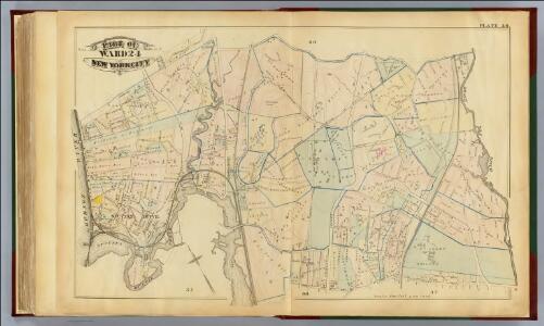
Plates 23 & 24: Southern Part of Yonkers and portion of West Farms.
from County atlas of Westchester, New York. Published by J.B. Beers & Co., assisted by S.W. Wilson and others.
Plates 23 & 24: Southern Part of Yonkers and portion of West Farms.
from County atlas of Westchester, New York. Published by J.B. Beers & Co., assisted by S.W. Wilson and others.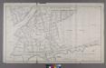
Section 18 of Final Maps and Profiles, of the 23rd & 24th Wards.
from Maps or plans and profiles, with field notes and explanatory remarks, showing the location, width, grades, and class of streets, roads, avenues, public squares and places, located and laid out by the Commissioner of Street Improvements of the 23rd and 24th wards of the city of New York : under authority of Chapter 545 of the laws of 1890.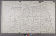
Map or Plan of Section 21. [Bounded by Riverdale Avenue, W. 238th Street, Spuyten Duvil Road, W. 240th Street, Van Cortlandt Avenue, Gun Hill Road, Sedgwick Avenue and Kingsbridge Road.]
from Maps or plans and profiles, with field notes and explanatory remarks, showing the location, width, grades, and class of streets, roads, avenues, public squares and places, located and laid out by the Commissioner of Street Improvements of the 23rd and 24th wards of the city of New York : under authority of Chapter 545 of the laws of 1890.
Plate 20: Yonkers, Westchester Co. N.Y. (Spuyten Duvil.)
from Atlas of New York and vicinity : from actual surveys / by and under the direction of F. W. Beers, assisted by A. B. Prindle & others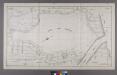
Section 20 of Final Maps and Profiles, of the 23rd & 24th Wards.
from Maps or plans and profiles, with field notes and explanatory remarks, showing the location, width, grades, and class of streets, roads, avenues, public squares and places, located and laid out by the Commissioner of Street Improvements of the 23rd and 24th wards of the city of New York : under authority of Chapter 545 of the laws of 1890.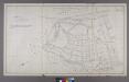
Section 22 of Final Maps and Profiles, of the 23rd & 24th Wards.
from Maps or plans and profiles, with field notes and explanatory remarks, showing the location, width, grades, and class of streets, roads, avenues, public squares and places, located and laid out by the Commissioner of Street Improvements of the 23rd and 24th wards of the city of New York : under authority of Chapter 545 of the laws of 1890.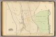
40 ward 24.
1 : 4800 Bromley, George Washington; Bromley, Walter Scott; G.W. Bromley & Co.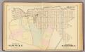
Olinville, Wakefield.
1 : 4800 Bromley, George Washington; Bromley, Walter Scott; G.W. Bromley & Co.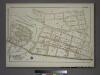
Plate 75, Part of Sections 8&13, Borough of the Bronx. [Bounded by Netherland Avenue, W. 235th Street, Spuyten Duyvil Road, W. 236th Street and Broadway.]
from Atlas of borough of the Bronx, Sections 9 10 11 12 & 13 : from actual surveys and official plans / G.W. Bromley and Co.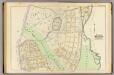
36 ward 24.
1 : 2400 Bromley, George Washington; Bromley, Walter Scott; G.W. Bromley & Co.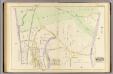
35 ward 24.
1 : 2400 Bromley, George Washington; Bromley, Walter Scott; G.W. Bromley & Co.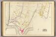
33, ward 24.
1 : 2400 Bromley, George Washington; Bromley, Walter Scott; G.W. Bromley & Co.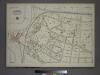
Plate 76, Part of Section 13, Borough of the Bronx. [Bounded by Spuyten Duyvil Road, W. 235th Street, Netherland Avenue, Kappock Street, W. Johnson Road and Broadway.]
from Atlas of borough of the Bronx, Sections 9 10 11 12 & 13 : from actual surveys and official plans / G.W. Bromley and Co.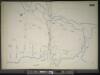
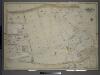
Manhattan, V. 11 1/2, Double Page Plate No. 255 [Map bounded by River St., Harlem River, W. 215th St.]
From Atlas 42.61. Vol. 11-11 1/2, 1893.
Sheet 4: Grid #9000E - 12000E, #1000N - 7000N. [Includes Gun Hill Road, Bronxwood Park, N.Y. - Harlem River R.R., Bronx Parl, Rosewood ,(Olinville), Olinville Avenue and White Plains Avenue.]
from Topographical survey and new street system of the borough of the Bronx, easterly of the Bronx River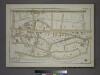
Plate 73, Part of Section 12, Borough of the Bronx. [Bounded by Broadway, W. 236th Street, Sedgwick Avenue, Kingsbridge Terrace, Albany Crescent, Heath Avenue and W. 230th Street.]
from Atlas of borough of the Bronx, Sections 9 10 11 12 & 13 : from actual surveys and official plans / G.W. Bromley and Co.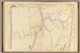
34 ward 24.
1 : 2400 Bromley, George Washington; Bromley, Walter Scott; G.W. Bromley & Co.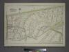
Plate 74, Part of Section 12, Borough of the Bronx. [Bounded by Van Cortlandt Park South, Mosholu Parkway, Sedgwick Avenue, W. 238th Street, Ft. Indepndence Street, W. 236th Street and Broadway.]
from Atlas of borough of the Bronx, Sections 9 10 11 12 & 13 : from actual surveys and official plans / G.W. Bromley and Co.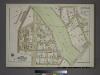
Plate 69, Part of Section 12, Borough of the Bronx. [Bounded by Jerome Avenue, E. 204th Street, Grand Boulevard, E. 202nd Street, Briggs Avenue, Mosholu Parkway South, Bainbridge Avenue, Reservoir Oval East and E. 208th Street.]
from Atlas of borough of the Bronx, Sections 9 10 11 12 & 13 : from actual surveys and official plans / G.W. Bromley and Co.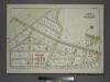
Plate 71, Part of Section 12, Borough of the Bronx. [Bounded by E. Jerome Avenue, Bainbridge Avenue and E. 208th Street.]
from Atlas of borough of the Bronx, Sections 9 10 11 12 & 13 : from actual surveys and official plans / G.W. Bromley and Co.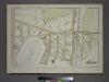
Plate 70, Part of Section 12, Borough of the Bronx. [Bounded by E. 211th Street, Webster Avenue, Parkside Place, E. 209th Street, Perry Avenue, Holt Place, Reservoir Oval East, Reservoir Oval West and Bainbridge Avenue.]
from Atlas of borough of the Bronx, Sections 9 10 11 12 & 13 : from actual surveys and official plans / G.W. Bromley and Co.
Manhattan, V. 12, Plate No. 29 [Map bounded by Harlem River, Spuyten Duyvil Creek]
From Atlas 128. Vol. 12, 1900.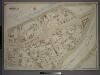
Double Page Plate No. 35, Part of Ward 24, Section 12. [Bounded by Jerome Avenue, Mosholu Parkway North, Briggs Avenue and E. 199th Street.]
from Atlas of the borough of the Bronx, city of New York : based upon official plans and maps on file in the various city offices; supplemented by careful field measurements and personal observations, by and under the supervision of Hugo Ullitz.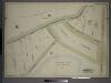
Double Page Plate No. 39, Part of Ward 24, Section 12. [Bounded by Jerome Ave. and Van Cortlandt Park South.]
from Atlas of the borough of the Bronx, city of New York : based upon official plans and maps on file in the various city offices; supplemented by careful field measurements and personal observations, by and under the supervision of Hugo Ullitz.
Double Page Plate No. 37, Part of Ward 24, Section 12. [Bounded by Bainbridge Avenue, E. 205th Street, Perry Avenue, E. 209th Street, Webster Avenue and E. Mosholu Parkway North.]
from Atlas of the borough of the Bronx, city of New York : based upon official plans and maps on file in the various city offices; supplemented by careful field measurements and personal observations, by and under the supervision of Hugo Ullitz.