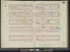
Maps of Hudson County
11. Ward 16.
1 : 2400 G.W. Bromley & Co.; Geo. W. Bromley & E. Robinson
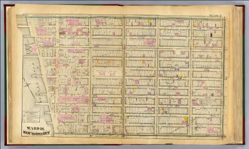
Part of Wards 16 &20, New York City.
from Atlas of the city of New York : embracing all territory within its corporate limits from official records, private plans & actual surveys / by and under the supervision of E. Robinson & R.H. Pidgeon, civil engineers.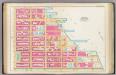
Pl. 15: ward 18.
1 : 1800 Bromley, George Washington; Bromley, Walter Scott
Manhattan, Double Page Plate No. 13 [Map bounded by W. 25th St., 7th Ave., W. 14th St., Hudson River]
From Atlas of the city of New York, Manhattan Island. From actual surveys and official plans
Part of Section 2 : New York City.
from Atlas of the city of New York, Manhattan Island. From actual surveys and official plans / by George W. and Walter S. Bromley.
Plate 13: Bounded by W. 25th Street, Seventh Avenue, W. 14th Street, [Hudson River, Pierhead Line, Piers 57-62], and Thirteenth Avenue.]
from Atlas of the city of New York, borough of Manhattan. From actual surveys and official plans / by George W. and Walter S. Bromley.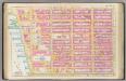
Pl. 13: ward 16.
1 : 1800 Bromley, George Washington; Bromley, Walter Scott
Part of Section 3 : Plate 48.
from Atlas of the borough of Manhattan, city of New York.
Plate 8, Part of Section 3: [Bounded by W. 26th Street, Seventh Avenue, W. 20th Street and (Chelsea Square) Ninth Avenue.]
from Atlas of the city of New York, borough of Manhattan. From actual surveys and official plans / by George W. and Walter S. Bromley.
Plate 8, Part of Section 3: [Bounded by W. 26th Street, Seventh Avenue, W. 20th Street and Ninth Avenue.]
from Atlas of the city of New York, borough of Manhattan. From actual surveys and official plans / by George W. and Walter S. Bromley.
Part of Section 3 : Plate47.
from Atlas of the borough of Manhattan, city of New York.
Plate 8, Part of Section 3: [Bounded by W. 26th Street, Seventh Avenue, W. 20th Street and Ninth Avenue.]
from Atlas of the city of New York, borough of Manhattan. From actual surveys and official plans / by George W. and Walter S. Bromley.
Plate 5, Part of Section 3: [Bounded by W. 20th Street, Seventh Avenue, W. 14th Street and Ninth Avenue.]
from Atlas of the city of New York, borough of Manhattan. From actual surveys and official plans / by George W. and Walter S. Bromley.
Page 1: [Bounded by W. 19th Street, Seventh Avenue, Greenwich Lane or Great-Kill Road and North River.]
from Maps of farms commonly called the Blue book, 1815 : drawn from the original on file in the street commissioner's office in the City of New York, together with lines of streets and avenues / laid out by John Randel, jr., 1819-20.
Part of Section : Plate 42.
from Atlas of the borough of Manhattan, city of New York.
Plate 7, Part of Section 3: [Bounded by W. 26th Street, Ninth Avenue, W. 20th Street, 13th Street, W. 23rd Street and Eleventh Avenue.]
from Atlas of the city of New York, borough of Manhattan. From actual surveys and official plans / by George W. and Walter S. Bromley.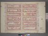
Plate 5, Part of Section 3: [Bounded by W. 20th Street, Seventh Avenue, W. 14th Street and Ninth Avenue.]
from Atlas of the city of New York, borough of Manhattan. From actual surveys and official plans / by George W. and Walter S. Bromley.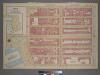
Plate 7, Part of Section 3: [Bounded by W. 26th Street, Ninth Avenue, W. 20th Street, Eleventh Avenue.]
from Atlas of the city of New York, borough of Manhattan. From actual surveys and official plans / by George W. and Walter S. Bromley.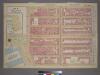
Plate 7, Part of Section 3: [Bounded by W. 26th Street, Ninth Avenue (Chelsea Square), W. 20th Street, 13th Street, W. 23rd Street and Eleventh Avenue.]
from Atlas of the city of New York, borough of Manhattan. From actual surveys and official plans / by George W. and Walter S. Bromley.
Part of Section 3 : Plate 41.
from Atlas of the borough of Manhattan, city of New York.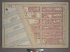
Plate 6, Part of Section 3: [Bounded by W. 20th Street, Ninth Avenue, W. 14th Street, (Hudson River Docks) Eleventh Ave.]
from Atlas of the city of New York, borough of Manhattan. From actual surveys and official plans / by George W. and Walter S. Bromley.
Plate 54: Bounded by W. 31st Street, Seventh Avenue, W. 26th Street, and Ninth Avenue.
from Atlas of the borough of Manhattan, city of New York.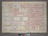
Plate 6, Part of Section 3: [Bounded by W. 20th Street, Ninth Avenue, W. 14th Street and Thirteenth Avenue.]
from Atlas of the city of New York, borough of Manhattan. From actual surveys and official plans / by George W. and Walter S. Bromley.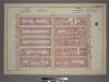
Plate 15, Part of Section 3: [Bounded by W. 31st Street, Seventh Avenue, W. 26th Street and Ninth Avenue.]
from Atlas of the city of New York, borough of Manhattan. From actual surveys and official plans / by George W. and Walter S. Bromley.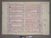
Plate 15, Part of Section 3: [Bounded by W. 32nd Street, Seventh Avenue, W. 26th Street and Ninth Avenue.]
from Atlas of the city of New York, borough of Manhattan. From actual surveys and official plans / by George W. and Walter S. Bromley.
[Plate 49: Bounded by W. 26th Street, Broadway (Madison Square), W. 20th Street, and Seventh Avenue.]
from Atlas of the borough of Manhattan, city of New York.
Page 2: [Bounded by Abingdon Road, Loves Lane, Sixth Avenue, W. Eleventh Street, Seventh Avenue, W. Fourteenth Street and Fitz Roy Road.]
from Maps of farms commonly called the Blue book, 1815 : drawn from the original on file in the street commissioner's office in the City of New York, together with lines of streets and avenues / laid out by John Randel, jr., 1819-20.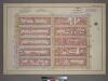
Plate 15, Part of Section 3: [Bounded by W. 31st Street, Seventh Avenue, W. 26th Street and Ninth Avenue.]
from Atlas of the city of New York, borough of Manhattan. From actual surveys and official plans / by George W. and Walter S. Bromley.
Manhattan, V. 5, Double Page Plate No. 85 [Map bounded by W. 27th St., 6th Ave., W. 22nd St., 8th Ave.]
From Atlas 42.55. Vol. 5, 1890.