Maps of United States
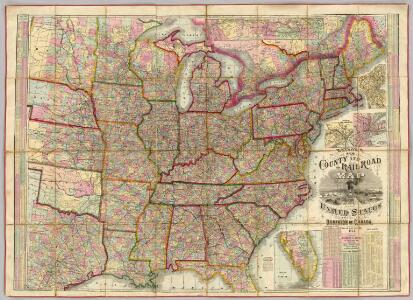
Watson's New County and Railroad Map of the United States.
1 : 2154240 Watson, Gaylord
A map of the United States, from the latest surveys.
1 : 4822000 Tuttle, Joseph Willard, 1813-1888
United States / by David H. Burr; engraved by S. Stiles & Co., N. York.
from Whole David H. Burr; S. Stiles & Co.,
Composite: United States of Nth. America.
1 : 1584000 Tardieu, P.F.
Map of the United States / Euphemia Fenno.
from Whole Euphemia Fenno,
Amplissimae regionis Mississipi seu provinciae Ludovicianae â R.P. Ludovico Hennepin Francisc. Miss. in America septentrionali anno 1687
1 : 6500000
United States.
1 : 1900800 Lay, Amos
United States.
1 : 5400000 W. & A.K. Johnston Limited
Amplissimae regionis Mississipi seu Provinciae Ludovicianae â R.P. Ludovico Hennepin Francisc Miss in America Septentrionali anno 1687
1 : 1
Amplissimae regionis Mississipi seu Provinciae Ludovicianae â R. P. Ludovico Hennepin francisc miss. in America septentrionali anno 1687 detectae, nunc Gallorum coloniis et actionum negotiis toto orbe celeberrimae, nova tabula
1 : 6350000 Mississippi, řeka-oblast Homann, Johann Baptist a Io. Bapt. Homanno
United States.
1 : 5400000 W. & A.K. Johnston Limited
Map of the United States of America.
from Whole s.n.: [Philadelphia?],
United States.
1 : 8000000 Teesdale, Henry
United States.
1 : 5400000 W. & A.K. Johnston Limited
United States.
1 : 8400000 Sharpe, J.
The eagle map of the United States
1 : 7500000
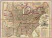
Railroad Map Of The United States And Of The Dominion Of Canada.
1 : 2280960 Watson, Gaylord
United States.
1 : 12500000 Tallis, J. & F.
United States of America / by H.S. Tanner, 1837; engraved by H.S. Tanner, assisted by E.B. Dawson, W. Allen & J. Knight.
from Whole Henry S. Tanner; E. B. Dawson; W. Allen; J. Knight,
Ensign's Travellers' guide and map of the United States : containing the roads, distances, steam boat and canal routes &c. / engraved on steel by J. Wells, Brooklyn, L.I.
from Whole
Map of the United States, constructed from the latest authorities
1 : 7000000
Map Of The United States Of North America.
1 : 2154240 Vance, David H.
New Map of the United States. (Proposal to publish.)
Vance, David H.
The United States of North America / engd. by Jno. Johnstone, Edinb.
from Whole John Johnstone, Edinb.,
Die Vereinigten Staaten von Nordamerika
Geographischer Atlas über alle Theile der Erde Ziegler, Jakob Melchior Verlag von Dietrich Reimer
Maps of the Eastern, Middle and Southern States: Atlantic states
Map of the Atlantic States, showing the principal railroad connections. L. Prang & Co.
Mitchell's map of the United States : showing the principal travelling turnpike and common roads, on which are given the distances in miles from one place to another, also the courses of the canals & rail roads throughout the country, carefully compi
from Whole
Die Vereinigten Staaten von Nordamerika
Geographischer Atlas über alle Theile der Erde Ziegler, Jakob Melchior Verlag von Joh. Wurster um Comp.
4. Population 1830-1860.
1 : 8450000 Gannett, Henry, 1846-1914; United States. Census Office
3. Population 1790-1820.
1 : 8450000 Gannett, Henry, 1846-1914; United States. Census Office
Foreign population 1870.
1 : 7200000 Walker, Francis Amasa, 1840-1897
US Population 1850.
1 : 7100000 Walker, Francis Amasa, 1840-1897
Illiteracy 1870.
1 : 7100000 Walker, Francis Amasa, 1840-1897
Enteric, cerebro-spinal, typhus deaths.
1 : 7200000 Walker, Francis Amasa, 1840-1897
Foreign parentage 1870.
1 : 7100000 Walker, Francis Amasa, 1840-1897
Colored population proportion 1870.
1 : 7100000 Walker, Francis Amasa, 1840-1897
White male illiteracy.
1 : 7100000 Walker, Francis Amasa, 1840-1897
Predominating sex US.
1 : 7200000 Walker, Francis Amasa, 1840-1897
US Population 1860.
1 : 7100000 Walker, Francis Amasa, 1840-1897
US Population 1790-1820.
1 : 14300000 Walker, Francis Amasa, 1840-1897
Public indebtedness US.
1 : 7200000 Walker, Francis Amasa, 1840-1897
Consumption deaths US.
1 : 7200000 Walker, Francis Amasa, 1840-1897
Intestinal diseases deaths US.
1 : 7200000 Walker, Francis Amasa, 1840-1897
Malarial deaths US.
1 : 7200000 Walker, Francis Amasa, 1840-1897
Taxation per capita US.
1 : 7200000 Walker, Francis Amasa, 1840-1897
Wealth distribution US.
1 : 7200000 Walker, Francis Amasa, 1840-1897
Foreign population proportion 1870.
1 : 7200000 Walker, Francis Amasa, 1840-1897
Irish, German population 1870.
1 : 14300000 Walker, Francis Amasa, 1840-1897
Foreign parentage proportion 1870.
1 : 7100000 Walker, Francis Amasa, 1840-1897
Farms, production, corn, dairy.
1 : 14300000 Walker, Francis Amasa, 1840-1897
Crops US.
1 : 14300000 Walker, Francis Amasa, 1840-1897
Birth rate US.
1 : 7200000 Walker, Francis Amasa, 1840-1897