Maps of Seven Seas (Open Ocean)
Die Vulkanischen Erscheinungen Der Atlen Welt.
1 : 65000000 Berghaus, Heinrich

Atlas über die Entwicklung von Industrie und Handel der Schweiz in dem Zeitraume vom Jahr 1770 bis zum Jahr 1870
1 : 45000000 1 Atlas ([3], VIII Bl.) im Auftrage der schweizerischen Commission für die additionellen Ausstellungen in Wien, bearbeitet von Dr. Hermann Wartmann Wurster Randegger & Co., Winterthur
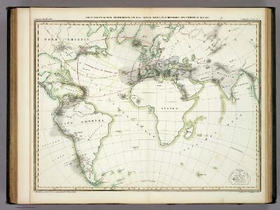
Le monde ou panorama géographique du globe terrestre, représentant les terres et les mers du globe, ses accidents physiques, les phénomènes, les règnes de la nature [...]
1 : 177600000 réd. d'après Mr. De Humbold et les savans les plus distingués par E. Hocquart [S.l.] : [s.n.]
Mappe-Monde = Geo-Hydrographique, ou Descritption Generale Du Globe Terrestre Et Aquatique En Deux-Plans-Hemispheres. [Karte], in: Atlas nouveau, contenant toutes les parties du monde [...], Bd. 1, S. 32.
1 Karte aus Atlas Sanson, Nicolas Jaillot, Alexis Hubert und Mortier, Pieter
Atlantic Ocean.
1 : 95000000 Huntington, Hezekiah, 1795-1865
Animals - World.
Woodbridge, William C.
Vorstellvng der in der Nacht zwischen den 8. u. 9. Aug; 1748
Mollova mapová sbírka Mayer, Tobias Homann, Johann Baptista - dědici
Die verfinsterte Erdkugel :
Mollova mapová sbírka Lowitz, Georg Moriz Schneider, Ruprecht Adam Homann, Johann Baptista - dědici
Orbis Terrarum Veteribus Cogniti Typus Geographicus. [Karte], in: Novus atlas absolutissimus, Bd. 10, S. 8.
1 Karte aus Atlas Janssonius Offizin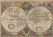
Nova Totius Terrarum Orbis Geographica Ac Hydrographica Tabula. [Karte], in: Novus atlas absolutissimus, Bd. 1, S. 14.
1 Karte aus Atlas Janssonius Offizin
Longueurs du pendule.
1 : 75000000 L'Isle, Guillaume de, 1675-1726
Objevy zemí na hranici středního a nového věku

Nova Totius Terrarum Orbis Gepgraphica Ac Hydrographica Tabula. [Karte], in: Gerardi Mercatoris et I. Hondii Newer Atlas, oder, Grosses Weltbuch, Bd. 1, S. 25.
1 Karte aus Atlas Mercator, Gerhard und Hondius, Jodocus Jansson, Jan
Inhabited World.
1 : 93000000 Woodbridge, William C.
Isothermal chart, productions.
1 : 80000000 Woodbridge, William C.
Carte générale du voyage pittoresque autour du monde : sur laquelle l'Océanie a été reduite d'après la carte de Mr. d'Urville & sous sa direction / gravé par Ambroise Tardieu
1 : 100000000 Dumont d'Urville, Jules Sébastian César; Tardieu, Ambroise [S.l. : s.n.]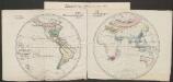
Pflanzengeographische Eintheilung der Erdoberfläche
1 : 50000000 Schouw, Joakim Frederik [Reimer?]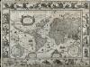
Nova Totius Terrarum Orbis Geographica Ac Hydrographica Tabula
Blaeu, Willem Janszoon; Ende, Josua van den
Planisphère illustré présentant la description géographique des parties connues de la terre : indiquant l'époque des grandes découvertes et le nom des navigateurs, les colonies des diverses nations ainsi que le parcours des bateaux à vapeur, l'époque des départs, la durée du trajet &c. / dressé par Vuillemin ; gravé par Langevin
1 : 34000000 Annotatie: Met diverse kostuumfiguren, overzicht van de hoogste bergen en overzicht van de langste rivieren Vuillemin, A.; Langevin, ... Paris : Fatout
[Erdkarte in Mercators Projektion, Übersicht der Meeresströmungen und der Weltverkehrlinien]
Volksschul-Atlas über alle Teile der Erde Lange, Henry Druck und Verlag von Georg Westermann
Verschiedenes zur Anthropographie
Zweiter Band, enthaltend in vier Abtheilungen die Vertheilung der Organismen: 5. Pflanzen-Geographie, 6. Thier-Geographie, 7. Anthropographie, 8. Ethnographie Humboldt, Alexander von Verlag von Justus Perthes
Isothermal chart.
1 : 95000000 Woodbridge, William C.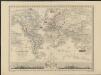
Nouveau planisphère indiquant les grandes divisions physiques et politiques de la terre, la géographie statistique et industrielle des differents états, les colonies européenes et l'époque des principales découvertes
1 : 47000000 dressé par A. Vuillemin gravé par Langevin Paris [etc.] : Turgis
Hyetographische Karte der Erde
Erster Band, enthaltend in vier Abtheilungen die Erscheinungen der anorganischen Natur: 1. Meteorologie und Klimatographie. 2. Hydrologie und Hydrographie. 3. Geologie. 4. Tellurischer Magnetismus Humboldt, Alexander von Verlag von Justus Perthes
Florenreiche der Erde auf der Grundlage von W. Köppens Wärmegürteln nach der Dauer der heissen, gemässigten und kalten Zeit
1 : 120000000 Drude, Oscar Engelhorn
VI. Charte für die allgemeine Geschichte von Carl dem Grossen bis auf Papst Gregor VII. : d.i. von 768 bis 1073 nach Christus
Entworfen von F.W. Benicken gez. von C.F. Weiland ; in Stein gravirt v. A. Falger Weimar : im Verlage des L. Industrie-Comptoirs
Nova Totius Terrarum Orbis Tabula
Danckerts, Justus
Übersicht der Mittleren Barometerstände am Meere und der Oscillation des Luftdrucks
Erster Band, enthaltend in vier Abtheilungen die Erscheinungen der anorganischen Natur: 1. Meteorologie und Klimatographie. 2. Hydrologie und Hydrographie. 3. Geologie. 4. Tellurischer Magnetismus Humboldt, Alexander von Verlag von Justus Perthes