Maps of Europe
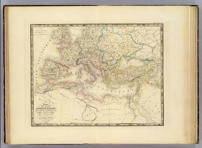
Empire Romain.
1 : 10800000 Andriveau-Goujon, J.
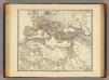
L'Empire Romain.
1 : 10200000 Lapie, M. (Pierre), 1779-1850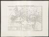
Carta generale dell'impero romano sotto Costantino
1 : 11000000 Marzolla, Benedetto [Verlag nicht ermittelbar]
Gemälde der grossen Wanderungen der Barbaren
Historisch-genealogisch-geographischer Atlas von Le Sage Las Cases, Emmanuel Auguste Dieudonné Marius Joseph de Johann Velten, Kunsthändler
Ancient Roman empire
J. Dower Henry Teesdale & C
A new map of Europe exhibiting its natural and political divisions drawn from the most recent materials
From Whole
Imperium Romanum.
1 : 15000000 Kiepert, Heinrich, 1818-1899
Europa antiqua cum finitimis Africæ & utriusque Asiæ regionibus / Nicolaus Blancardus ... delineabat
1 : 10000000 Annotatie: Origineel is Blad 2 in atlas factice Blanckaert, Nicolaas [Amsterdam : Joannes Janssonius]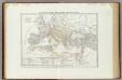
Carta generale dell'Impero Romano sotto Costantino.
1 : 11500000 Marzolla, Benedetto
Der europäische Raum
1 : 6000000 Afrika severní Richard Schwarz, Landkarten-Handlung und Geogr. Verlag
Der europäische Kontinent
1 : 7500000 Evropa Verlagsanstalt List und von Bressensdorf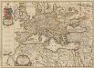
Europa Antiqua cum finitimis Africae & utriusque Asiae regionibus. [Karte], in: Novus atlas absolutissimus, Bd. 10, S. 33.
1 Karte aus Atlas Janssonius Offizin
Europe : laid down from the observations of the Royal Academy of Sciences & compared with the maps of Sanson, Nolin, Du Fer, De l'Isle, Moll & other modern geographers ... / [John Bowles] ; engrav'd by Emanuel Bowen
1 : 4500000 Annotatie: Met tabel van Europese lengtematen; Met informatie over de verschillende Europese staten Bowles, John; Bowen, Emanuel London : printed for John Bowles
[Karte von Europa, Zur Übersicht der Wärme-Verbreitung in diesem Erdtheile]
Erster Band, enthaltend in vier Abtheilungen die Erscheinungen der anorganischen Natur: 1. Meteorologie und Klimatographie. 2. Hydrologie und Hydrographie. 3. Geologie. 4. Tellurischer Magnetismus Humboldt, Alexander von Verlag von Justus Perthes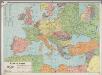
[LL.03966gk: 100/od/1939], uit: Kaart van Europa
1 : 5000000 Annotatie: Met lijst van landennamen (in het Nederlands en in de landstaal) en enkele afstanden naar hemelsbreedte Rotterdam : Spanjersberg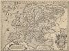
Europam, Sive Celticam Veterem [Karte], in: Theatrum orbis terrarum, S. 453.
1 Karte aus Atlas Ortelius, Abraham Vrients, Jan Baptista
Europa Post Bellum Triginta Annorum. (1650-1700)
Europa Westfälischer Friede
Europa Exactissime Descripta [Karte], in: Gerardi Mercatoris et I. Hondii Newer Atlas, oder, Grosses Weltbuch, Bd. 1, S. 30.
1 Karte aus Atlas Mercator, Gerhard und Hondius, Jodocus Jansson, Jan
Imperium Romanum tempore Constantini Magni

Europa
Geographischer Atlas über alle Theile der Erde Ziegler, Jakob Melchior Verlag von Dietrich Reimer
Europa um die Mitte des Vierzehnten Jahrhunderts
1 : 15000000 Europa
Carte Geologique De L'Europe.
1 : 3800000 Dumont, Andre
Europa vom Westfälischen Frieden 1648 bis zur Zersplitterung der grossen spanischen Monarchie 1700 (Zeitraum der Übermacht Frankreichs)
1 : 15000000 Europa, Westfälischer Friede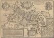
Romani Imperioo Imago. [Karte], in: Theatrum orbis terrarum, S. 450.
1 Karte aus Atlas Ortelius, Abraham Vrients, Jan Baptista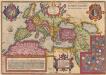
Romani Imperii Imago. [Karte], in: Theatrum orbis terrarum, S. 451.
1 Karte aus Atlas Ortelius, Abraham
Europa Übersicht der politischen Verhältnisse und Hauptverkehrswege
1 : 20000000 Europa Verkehrsnetz
Europe.
1 : 21542400 Lucas, Fielding Jr.
Europa nach dem Wiener Congress 1815
1 : 15000000 Europa
Europa. Staaten
1 : 24000000 Europa Politische Geografie