Maps of Ford County

Maps of Ford County

$title$

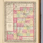
Kankakee, Iroquois, Ford counties.

1 : 350000 Campbell, R.A.
$title$

Map of Iroquois County.

1 : 165000 Warner & Beers
$title$

Map of Ford County and Paxton.

1 : 126720 Warner & Beers
$title$

Map of Kankakee County, Kankakee and Gilman.

1 : 158400 Warner & Beers
$title$

Buckley

1 : 62500
$title$

Cissna Park

1 : 62500
$title$

Cissna Park

1 : 62500
$title$

Cissna Park

1 : 62500
$title$

Buckley

1 : 62500
$title$

Cissna Park

1 : 62500
$title$

Piper City

1 : 62500
$title$

Gilman

1 : 62500
$title$

Piper City

1 : 62500
$title$

Piper City

1 : 48000
$title$

Gilman

1 : 62500
$title$

Gilman

1 : 62500
$title$

Herscher

1 : 62500
$title$

Kankakee

1 : 62500
$title$

Herscher

1 : 62500
$title$

Herscher

1 : 62500
$title$

Kankakee

1 : 62500
$title$

Milford

1 : 62500
$title$

Milford

1 : 62500
$title$

Milford

1 : 48000
$title$

Watseka

1 : 62500
$title$

Watseka

1 : 62500
$title$

Watseka

1 : 48000
$title$

Momence

1 : 62500
$title$

Momence

1 : 62500
$title$

Momence

1 : 62500
© MapTiler © OpenStreetMap contributors
How does it work?
These instructions will show you how to find historical maps online.
Getting started
Type the place name in the search box to find the exact location. You can further adjust the search by zooming in and out.
Zoom
Zoom in and out with the buttons or use your mouse or touchpad natively.
Exact Area tool
Click here and draw a rectangle over the map to precisely define the search area.
Set filters
Narrow your search with advanced settings, such as Years (from/to), Fulltext, Publisher, etc.
Results
See the results of your search on the right side. You can scroll down to find more maps of this location.
?

Download OldMapsOnline Mobile