Maps of Los Angeles County

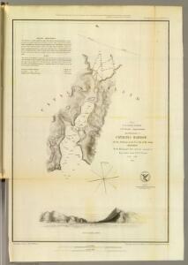
Catalina Harbor.
1 : 15000 Bache, A. D.
Santa Catalina Island
1 : 100000
Commutation time (at 15 minute intervals) and distribution of population, Los Angeles County, 1930.
1 : 1200000 Commuting California Los Angeles County. Hand colored. "Source: Regional Planning Commission, Los Angeles." United States. Federal Housing Administration. Division of Economics & Statistics. [Washington, D.C.?] Federal Housing Administration, Division of Economics and Statistics
Long Beach
1 : 250000
Long Beach
1 : 250000
Long Beach
1 : 250000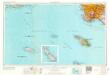
Long Beach
1 : 250000
Long Beach
1 : 250000
Long Beach
1 : 250000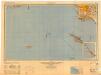
Long Beach
1 : 250000
Map of a part of Southern California, showing gaging stations
1 : 1250000 Relief shown by contours and spot heights. Map is plate 1 and 2 from the U.S. Geological Survey's Water- supply paper 447. Includes index. Geologic Survey (U.S.) [Washington, D.C.] : U.S. Geological Survey, 1920.
Map and condensed profile showing Los Angeles Aqueduct, completed in 1913, and proposed extension to Mono Basin : also condensed profile of Colorado River Aqueduct now under construction by Metropolitan Water District.
1 : 1430000 One map shows southern portion of Los Angeles Aqueduct (to Fairmont Reservoir) and the route of the Colorado River Aqueduct; the other map shows the Los Angeles Aqueduct and proposed Mono Craters Tunnel. Photostat. Los Angeles Aqueduct hand colored in red and blue on one map. Los Angeles (Calif.). Bureau of Water Works & Supply. [Los Angeles, Calif.? : Bureau of Water Works and Supply?]
Ventura, Los Angeles, San Bernardino, Orange, and San Diego Counties.
1 : 760320 Blum, George W.
Topographic map of the Los Angeles Aqueduct and adjacent territory
1 : 1316800 Relief shown by contours and hachures. Blue line print. Includes "Key to index system." Map Library copy annotated in colored pen. [California? : s.n.]
Topographic Map of the Los Angeles Aqueduct and Adjacent Territory
1 : 1316800 [California? : s.n.]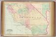
Calif., Nev. south.
1 : 1267200 Asher & Adams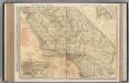
California (Southern Section).
1 : 1140000 Rand McNally and Company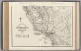
California. Nevada.
1 : 1341000 Rand McNally and Company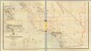
California, Nevada (lower)
1 : 696960 Von Haake, A.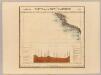
Partie, Nouvle. Californie. Amer. Sep. 52.
1 : 1641836 Vandermaelen, Philippe, 1795-1869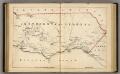
Southern California.
1 : 3300000 Holdredge, Sterling M.
Publicity map
1 : 1750000 Shows routes for "present Los Angeles Aqueduct," "present Los Angeles power line," Metropolitan Aqueduct, under construction," "All American Canal." Also shows location of "Mono Basin Project, under construction," and "Owens River Project, future." "Drawn A.E.A." Blueline print. "Drawing number L-287." Los Angeles (Calif.). Bureau of Power and Light. Los Angeles : Bureau of Power and Light, Department of Water & Power.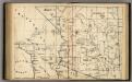
Arizona.
1 : 3400000 Holdredge, Sterling M.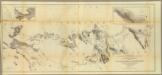
From the Rio Grande to the Pacific Ocean.
1 : 950400 Whipple, A.W.
California and Nevada. South Portion.
1 : 1290000 Asher & Adams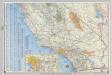
Shell Highway Map of California (southern portion).
1 : 1330560 Shell Oil Company
Map of California Roads for Cyclers.
1 : 1203840 Blum, George W.
Cote NO, l'Amerique 1.
1 : 1500000 Vancouver, George, 1757-1798
The Coast of N.W. America.
1 : 1290000 Vancouver, George, 1757-1798