Maps of Rheinland-Pfalz

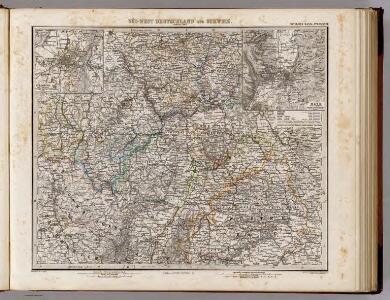
Sud-West Deutschland Und Schweiz.
1 : 925000 Vogel, C.
[Süd-West Deutschland und Schweiz, Nördlicher Theil]
Hand-Atlas über alle Theile der Erde und über das Weltgebäude Stieler, Adolf Justus Perthes
Süd-West Deutschland und Schweiz
Adolf Stieler's Handatlas über alle Theile der Erde und über das Weltgebäude Stieler, Adolf Justus Perthes
[Süd-West Deutschland und Schweiz, Nördlicher Theil]
Handatlas über alle Theile der Erde und über das Weltgebäude Stieler, Adolf Justus Perthes
Land Charte zum Schau Platz des Kriegs der Röm Kaiserl Maje und dero hohen Alliirten am Rhein
1 : 840000 Mollova mapová sbírka Riegel, Christoph Riegel, Christoph
Accurate Land Charte des Rheins Mossel und Neckar-Stroms
1 : 845700 Mosela, řeka-oblast Christoph Riegel
Landskarte zum Schauplatz des Kriegs der Röm. Kaisers. Maje. und dero hohen alliirten am Rhein
1 : 840000 Německo Christoph Kriegel
Mappa Geographica summo labore, accurate et novissime exarata, exhibens Circulos aliquot Germaniae, praesertim illos ubi Bellum nunc Geritur
1 : 1300000 Mollova mapová sbírka Lotter, Tobias Conrad Lotter, Tobias Conrad
Carte Generale d'Allemagne
1 : 1300000 Mollova mapová sbírka Eisenschmidt, Johann Caspar Julien, Roch Joseph
[Southwest Germany]
1 : 1400000 [S.l. : s.n.]
Haut, Bas Rhin.
1 : 640000 Robert de Vaugondy, Gilles, 1688-1766
Charte Von Mosel Saar Neccar-Rhein- und Mayn-Strom
1 : 780000 Mollova mapová sbírka Riegel, Christoph Riegel, Christoph
Westdeutschland
Volksschul-Atlas über alle Teile der Erde Lange, Henry Druck und Verlag von Georg Westermann
Teatre de la Guerre sur le Rhein, Moessele, Mayn & Necker
1 : 420000 Mollova mapová sbírka Sanson, Guillaume Covens, Johannes I
Mappa in qua Armisonum Martis Theatrum, ad Rhenum et Mosellam geographico stilo Exacte delineatur
1 : 1200000 Mollova mapová sbírka
Sheet I: Karte Des Oesterreichischen Kaiserstaates.
1 : 576000 Scheda, Josef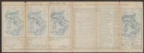
Secunda Rheni Et IX. Nova Tabula. [Karte], in: Claud. Ptolemaeus. Geographia lat. cum mappis [...], S. 362.
1 Karte aus Atlas Münster, Sebastian [und Ptolemaeus, Claudius]
Théatre de la guerre, ou carte des frontières de la république française et de l'empire d'Allemagne, 2
1 Teil : Delamarche
I, uit: General-Karte des oesterreichischen Kaiserstaates mit einem grossen Theile der angrenzenden Länder / durch Josef Scheda ... bearb. und hrsg
1 : 576000 Annotatie geografische gegevens: Maatstokken: oesterreichische Meilen, geografische oder deutsche Meilen, preussische Meilen, türkische Berri, französische Lieues, russische Werste; Maatstok per blad: wiener Klafter, öster. Meilen; Blad XIX: statistische en taalkundige informatie; Blad XIX: legenda [Wien : K.K. Militärisch-Geografisches Institut]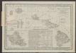
Le Cercle Eslectorial Du Rhein subdivié entous les Estats qui le composent [Karte], in: Atlas nouveau, contenant toutes les parties du monde [...], Bd. 1, S. 290.
1 Karte aus Atlas Sanson, Nicolas Jaillot, Alexis Hubert und Mortier, Pieter

General-Karte des österreichischen Kaiserstaates mit einem großen Theile der angrenzenden Länder
1 : 576000 Scheda, Josef k.k. Militärgeograph. Inst.
1:500,000 Europe (Air) G.S.G.S. No. 4072, Strasbourg
Sheet NE48-6 from the map series: 1:500,000 Europe (Air) G.S.G.S. No. 4072.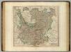
Upper, Lower Rhine circles.
1 : 700000 Cary, John, ca. 1754-1835
Smulders' kompas van het westelijk front
1 : 570000 Annotatie: Met informatie over o.a. inwoneraantal en productiegoederen van een aantal landen in de wereld; Annotatie geografische gegevens: De kaart toont de Maginotlinie en de Siegfriedlinie 's-Gravenhage : Smulders
Carte des cercles du Haut et Bas Rhin
1 : 1000000 Alsasko (Francie) Mentelle, Edme Tardieu, Pierre François
Circolo Elettorale del Reno
1 : 730000 Mollova mapová sbírka Mariotti, Vincenzo De Rossi, Giovanni Giacomo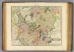
Upper, Lower Rhine.
1 : 720000 Lizars, Daniel