Maps of Rye
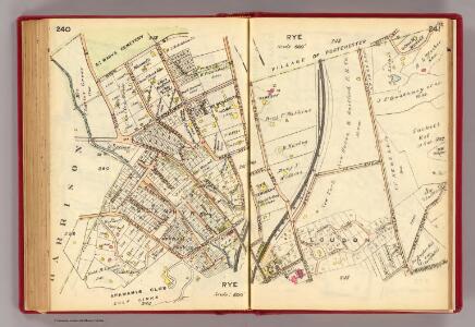
240-241 Rye.
1 : 7200 G.W. Bromley & Co.
242-243 Rye.
1 : 7200 G.W. Bromley & Co.
248-249 Port Chester.
1 : 5940 G.W. Bromley & Co.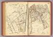
244-245 Rye.
1 : 7200 G.W. Bromley & Co.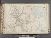
Westchester, V. 1, Double Page Plate No. 35 [Map bounded by Town of Rye, Village of Port Chester, Long Island Sound, Apawamis Ave., North St., Town of Harrison]
From Vol. 1
4 Atlas rural country district north of New York City.
1 : 13000 Hyde, E. Belcher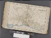
Westchester, Double Page Plate No. 19 [Map bounded by Regent St., Connecticut] / prepared under the direction of Joseph R. Bien, from general surveys and official records.
From Atlas of Westchester County, New York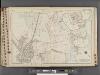
Westchester, V. 1, Double Page Plate No. 34 [Map bounded by North St., Apawamis Ave., Long Island Sound, Milton Harbor, York Ave., Calvert St., Nelson Ave.]
From Vol. 1
Plate 65: Port Chester, Town of Rye, Westchester Co. N.Y.
from County atlas of Westchester, New York. Published by J.B. Beers & Co., assisted by S.W. Wilson and others.
Plate 47: Port Chester, Westchester Co. N.Y.
from Atlas of New York and vicinity : from actual surveys / by and under the direction of F. W. Beers, assisted by A. B. Prindle & others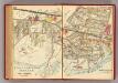
252-253 Port Chester.
1 : 5940 G.W. Bromley & Co.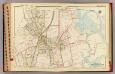
Rye.
1 : 4800 Bromley, George Washington; Bromley, Walter Scott; G.W. Bromley & Co.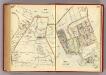
234-235 Rye.
1 : 7200 G.W. Bromley & Co.
Mamaroneck
1 : 24000
Mamaroneck
1 : 24000
Mamaroneck
1 : 24000
Mamaroneck
1 : 24000
Mamaroneck
1 : 24000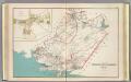
White Plains, Harrison, Rye towns.
1 : 27600 Bien, Joseph Rudolf
Harrison, Rye towns.
1 : 31680 Beers, F. W. (Frederick W.)
Town of Rye, Westerchester Co. N.Y.
from County atlas of Westchester, New York. Published by J.B. Beers & Co., assisted by S.W. Wilson and others.
Town of Rye, Westerchester Co. N.Y.
from County atlas of Westchester, New York. Published by J.B. Beers & Co., assisted by S.W. Wilson and others.
5. Larchmont-Kensico Sta.-Hartsdale-Greenwich.
1 : 80000 Servoss, R. D.
5. Larchmont-Kensico Sta.-Hartsdale-Greenwich.
1 : 80000 Servoss, R. D.
Map of Westchester Co.
1 : 45000 G.W. Bromley & Co.
Westchester Co., Yonkers-state line.
1 : 31680 Bien, Joseph Rudolf; Vermeule, C. C. (Cornelius Clarkson), 1858-1950
Westchester Co., Yonkers-state line.
1 : 31680 Vermeule, C. C. (Cornelius Clarkson), 1858-1950
Town of Greenwich, Fairfield County, Connecticut.
1 : 38169 Beers, Frederick W.
Oyster Bay
1 : 62500
Oyster Bay
1 : 62500
Oyster Bay
1 : 62500
Oyster Bay
1 : 62500
Oyster Bay
1 : 62500
Oyster Bay
1 : 62500
Oyster Bay
1 : 62500
Oyster Bay
1 : 62500
Oyster Bay
1 : 62500
Oyster Bay
1 : 62500
Oyster Bay
1 : 62500
Oyster Bay
1 : 62500
Oyster Bay
1 : 62500
Oyster Bay
1 : 62500
Oyster Bay
1 : 62500
Oyster Bay
1 : 62500