Maps of Nassau County
208-209 Mamaroneck.
1 : 7200 G.W. Bromley & Co.
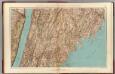
Plate 43: Mamaroneck, Westchester Co. N.Y. - Rye Neck.
from Atlas of New York and vicinity : from actual surveys / by and under the direction of F. W. Beers, assisted by A. B. Prindle & others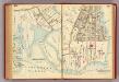
210-211 Mamaroneck.
1 : 7200 G.W. Bromley & Co.
Ryeneck, Town of Rye, Westchester Co. N.Y.
from County atlas of Westchester, New York. Published by J.B. Beers & Co., assisted by S.W. Wilson and others.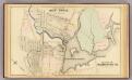
Rye Neck, Mamaroneck
1 : 4800 Bromley, George Washington; Bromley, Walter Scott; G.W. Bromley & Co.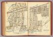
224-225 Mamaroneck.
1 : 7200 G.W. Bromley & Co.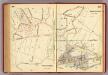
216-217 Mamaroneck.
1 : 7200 G.W. Bromley & Co.
Mamaroneck Town, Orienta.
1 : 23760 Beers, F. W. (Frederick W.)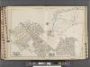
Westchester, V. 1, Double Page Plate No. 32 [Map bounded by Town of Mamaroneck, Union Ave., Nelson Ave., Harrison Ave., Stony Creek]
From Vol. 1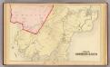
Harrison, Rye.
1 : 12000 Bromley, George Washington; Bromley, Walter Scott; G.W. Bromley & Co.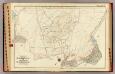
Mamaroneck town, village.
1 : 4800 Bromley, George Washington; Bromley, Walter Scott; G.W. Bromley & Co.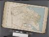
Westchester, Double Page Plate No. 16 [Map bounded by Larchmont Harbor, Long Island Sound, Boston Rd., Palmer Ave.] / prepared under the direction of Joseph R. Bien, from general surveys and official records.
From Atlas of Westchester County, New York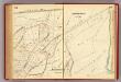
214-215 Mamaroneck.
1 : 7200 G.W. Bromley & Co.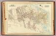
Mamaroneck, Larchmont.
1 : 4800 Bromley, George Washington; Bromley, Walter Scott; G.W. Bromley & Co.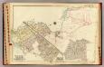
Rye Neck, Harrison.
1 : 4800 Bromley, George Washington; Bromley, Walter Scott; G.W. Bromley & Co.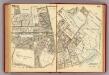
200-201 Larchmont.
1 : 7200 G.W. Bromley & Co.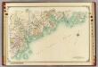
2 Atlas rural country district north of New York City.
1 : 13000 Hyde, E. Belcher
Plate 42: Town of Mamaroneck, Westchester Co. N.Y. - Orienta.
from Atlas of New York and vicinity : from actual surveys / by and under the direction of F. W. Beers, assisted by A. B. Prindle & others
Scarsdale, New Rochelle, Mamaroneck towns.
1 : 21120 Bien, Joseph Rudolf
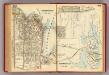
Plate 59: Town of Mamaroneck, Westchester Co. N.Y.
from County atlas of Westchester, New York. Published by J.B. Beers & Co., assisted by S.W. Wilson and others.
Harrison, Rye towns.
1 : 31680 Beers, F. W. (Frederick W.)
Town of Rye, Westerchester Co. N.Y.
from County atlas of Westchester, New York. Published by J.B. Beers & Co., assisted by S.W. Wilson and others.
Plates 53 & 54: Town of New Rochelle, Westchester Co. N.Y. - Town of Pelham, Westchester Co. N.Y. - City Island, Pelham Township, Westchester Co. N.Y.
from County atlas of Westchester, New York. Published by J.B. Beers & Co., assisted by S.W. Wilson and others.
5. Larchmont-Kensico Sta.-Hartsdale-Greenwich.
1 : 80000 Servoss, R. D.
Small folder - S1
from Atlas of New York and vicinity : from actual surveys / by and under the direction of F. W. Beers, assisted by A. B. Prindle & others
5. Larchmont-Kensico Sta.-Hartsdale-Greenwich.
1 : 80000 Servoss, R. D.
Plan of East Chester, Pelham and New Rochelle, Westchester County, New York.
1 : 42240 Beers, Frederick W.
Map of Westchester Co.
1 : 45000 G.W. Bromley & Co.
Westchester, Double Page Plate No. 3 [Map of Towns of Westchester and Pelham] / prepared under the direction of Joseph R. Bien, from general surveys and official records.
From Atlas of Westchester County, New York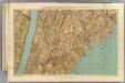
Westchester Co., Yonkers-state line.
1 : 31680 Bien, Joseph Rudolf; Vermeule, C. C. (Cornelius Clarkson), 1858-1950