Maps of New Rochelle

Maps of New Rochelle

$title$

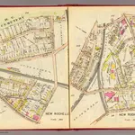
150-151 New Rochelle.

1 : 3600 G.W. Bromley & Co.
$title$

New Rochelle wards 1-4.

1 : 2400 Bromley, George Washington; Bromley, Walter Scott; G.W. Bromley & Co.
$title$

138-139 New Rochelle.

1 : 3600 G.W. Bromley & Co.
$title$

Plate 55 & 56: Part of New Rochelle, Westchester Co. N.Y.

from County atlas of Westchester, New York. Published by J.B. Beers & Co., assisted by S.W. Wilson and others.
$title$

Plate 55 & 56: Part of New Rochelle, Westchester Co. N.Y.

from County atlas of Westchester, New York. Published by J.B. Beers & Co., assisted by S.W. Wilson and others.
$title$

New Rochelle wards 1-2.

1 : 2400 Bromley, George Washington; Bromley, Walter Scott; G.W. Bromley & Co.
$title$

134-135 New Rochelle.

1 : 5400 G.W. Bromley & Co.
$title$

146-147 New Rochelle.

1 : 3600 G.W. Bromley & Co.
$title$

148-149 New Rochelle.

1 : 3600 G.W. Bromley & Co.
$title$

126-127 Pelham Manor, New Rochelle.

1 : 5400 G.W. Bromley & Co.
$title$

142-143 New Rochelle.

1 : 3600 G.W. Bromley & Co.
$title$

Pelham, Pelham-Manor.

1 : 14400 Bromley, George Washington; Bromley, Walter Scott; G.W. Bromley & Co.
$title$

Plate 38: New Rochelle, Westchester Co. N.Y.

from Atlas of New York and vicinity : from actual surveys / by and under the direction of F. W. Beers, assisted by A. B. Prindle & others
$title$

Height District Map Section No. 2; Height district map / City of New York, Board of Estimate and Apportionment.

from Height district map / City of New York, Board of Estimate and Apportionment. New York (N.Y.). Board of Estimate and Apportionment,
$title$

Use District Map Section No. 2; Use district map / City of New York, Board of Estimate and Apportionment.

from Use district map / City of New York, Board of Estimate and Apportionment. New York (N.Y.). Board of Estimate and Apportionment,
$title$

Westchester, Double Page Plate No. 14 [Map bounded by Pelham Winthrop St., Echo Ave., Long Island Sound] / prepared under the direction of Joseph R. Bien, from general surveys and official records.

From Atlas of Westchester County, New York
$title$

Westchester, Double Page Plate No. 15 [Map bounded by Mamaroneck, Long Island Sound, Liberty Ave.] / prepared under the direction of Joseph R. Bien, from general surveys and official records.

From Atlas of Westchester County, New York
$title$

Area District Map Section No. 2

from Area district map / City of New York, Board of Estimate and Apportionment.
$title$

New Rochelle, Town; Pelhamville.

1 : 31680 Beers, F. W. (Frederick W.)
$title$

Plate 42: Town of Mamaroneck, Westchester Co. N.Y. - Orienta.

from Atlas of New York and vicinity : from actual surveys / by and under the direction of F. W. Beers, assisted by A. B. Prindle & others
$title$

Scarsdale, New Rochelle, Mamaroneck towns.

1 : 21120 Bien, Joseph Rudolf
$title$

Mount Vernon

1 : 24000
$title$

Mount Vernon

1 : 24000
$title$

Mount Vernon

1 : 24000
$title$

Mount Vernon

1 : 24000
$title$

Mount Vernon

1 : 24000
$title$

Mount Vernon

1 : 24000
$title$

Mount Vernon

1 : 24000
$title$

Mt Vernon

1 : 24000
$title$

From New York to Stratford. (2)

1 : 35000 Colles, Christopher
© MapTiler © OpenStreetMap contributors
How does it work?
These instructions will show you how to find historical maps online.
Getting started
Type the place name in the search box to find the exact location. You can further adjust the search by zooming in and out.
Zoom
Zoom in and out with the buttons or use your mouse or touchpad natively.
Exact Area tool
Click here and draw a rectangle over the map to precisely define the search area.
Set filters
Narrow your search with advanced settings, such as Years (from/to), Fulltext, Publisher, etc.
Results
See the results of your search on the right side. You can scroll down to find more maps of this location.
?

Download OldMapsOnline Mobile