Maps of Mount Vernon
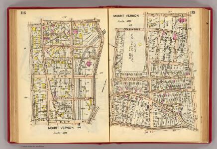
114-115 Mt. Vernon.
1 : 3600 G.W. Bromley & Co.
108-109 Mt. Vernon.
1 : 3600 G.W. Bromley & Co.
104-105 Mt. Vernon.
1 : 3600 G.W. Bromley & Co.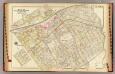
Mt. Vernon wards 1, 3, 5.
1 : 2400 Bromley, George Washington; Bromley, Walter Scott; G.W. Bromley & Co.
Lakeville - Washingtonville - East Chester.
from County atlas of Westchester, New York. Published by J.B. Beers & Co., assisted by S.W. Wilson and others.
Sheet 12: Grid #12000E - 16000E, #15000N - 18000N. [Includes part of the City of Mount Vernon, Seton Avenue, Monticello Avenue, Hill Avenue, Murdock Avenue, Wilder Avenue, Amundson Avenue, Bell Avenue, Pratt Avenue and Northern boundary of the City of Ne
from Topographical survey and new street system of the borough of the Bronx, easterly of the Bronx River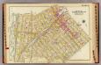
Mt. Vernon wards 2-5.
1 : 2400 Bromley, George Washington; Bromley, Walter Scott; G.W. Bromley & Co.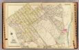
Mt. Vernon ward 1.
1 : 2400 Bromley, George Washington; Bromley, Walter Scott; G.W. Bromley & Co.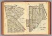
112-113 Mt. Vernon.
1 : 3600 G.W. Bromley & Co.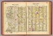
100-101 Mt. Vernon.
1 : 3600 G.W. Bromley & Co.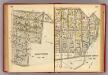
116-117 Mt. Vernon.
1 : 3600 G.W. Bromley & Co.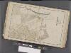
Westchester, Double Page Plate No. 9 [Map bounded by Pelham, Randal Ave., Mundys Lane, E. 5th St.] / prepared under the direction of Joseph R. Bien, from general surveys and official records.
From Atlas of Westchester County, New York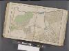
Westchester, Double Page Plate No. 12 [Map bounded by Pelham, E. 5th St., Rich Ave., East Chester] / prepared under the direction of Joseph R. Bien, from general surveys and official records.
From Atlas of Westchester County, New York
2A - N.Y. City (Aerial Set).
from Sectional aerial maps of the City of New York / [photographed and assembled under the direction of the chief engineer, July 1st, 1924].
Height District Map Section No. 2; Height district map / City of New York, Board of Estimate and Apportionment.
from Height district map / City of New York, Board of Estimate and Apportionment. New York (N.Y.). Board of Estimate and Apportionment,
Use District Map Section No. 2; Use district map / City of New York, Board of Estimate and Apportionment.
from Use district map / City of New York, Board of Estimate and Apportionment. New York (N.Y.). Board of Estimate and Apportionment,
Plate 52: Wakefield, Town & County of Westchester, N.Y.
from County atlas of Westchester, New York. Published by J.B. Beers & Co., assisted by S.W. Wilson and others.
1 Atlas rural country district north of New York City.
1 : 13000 Hyde, E. Belcher
Area District Map Section No. 2
from Area district map / City of New York, Board of Estimate and Apportionment.
E. Chester, Town.
1 : 21120 Beers, F. W. (Frederick W.)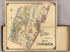
2 Yonkers.
1 : 18000 Hyde & Company
Plate 42: Town of Mamaroneck, Westchester Co. N.Y. - Orienta.
from Atlas of New York and vicinity : from actual surveys / by and under the direction of F. W. Beers, assisted by A. B. Prindle & others
Westchester, Pelham towns.
1 : 21120 Bien, Joseph Rudolf
Topographical atlas of the city of New York, including the annexed territory showing original water courses and made land. / prepared under the direction of Egbert L. Viele.
From Topographical atlas of the city of New York, including the annexed territory showing original water courses and made land
Yonkers and East Chester, Westchester County, New York.
1 : 23760 Beers, J.B.
Yonkers, Town.
1 : 19800 Beers, F. W. (Frederick W.)
Yonkers, Mt. Vernon, Eastchester towns.
1 : 21120 Bien, Joseph Rudolf
Mount Vernon
1 : 24000
Mount Vernon
1 : 24000
Mount Vernon
1 : 24000
Mount Vernon
1 : 24000
Mount Vernon
1 : 24000
Mount Vernon
1 : 24000
Mount Vernon
1 : 24000