Maps of Coastal Plain
Southern dominions U.S.
1 : 3100000 Robert Laurie & James Whittle
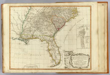
A General Map of the Southern British Colonies, in America.
1 : 3000000 Robert Sayer and John Bennett (Firm)
Carolinas, Georgia, Floridas, Bahamas.
1 : 3300000 Cary, John, ca. 1754-1835
A GENERAL MAP OF THE SOUTHERN BRITISH COLONIES IN AMERICA
1 : 3000000 Bahamy (souostroví) Romans, Bernard Collet, John Abraham
A general map of the southern British colonies, in America comprehending North and South Carolina, Georgia, East and West Florida, with the neighbouring Indian countries : from the modern surveys of Engineer de Brahm, Capt. Collet, Mouzon & others
1 : 3000000 Romans, Bernard Robert Sayer & John Bennett (Firm)
Virginia, North Carolina, South Carolina, and Georgia.
1 : 6019200 Morse, Jedidiah
145-46. Ark., Tenn., La., Miss., Fla., Ala., Ga., S.C.
1 : 3000000 Touring club italiano
S. section U.S.
1 : 4200000 Melish, John
Perrine's New Military Map Illustrating The Seat of War.
1 : 2724480 Perrine, Charles O.
Southern section of the United States, including Florida &c. / by John Melish, 1816.
from Parts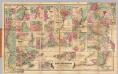
Colton's Plans Of U.S. Harbors.
Colton, J. H.
The historical war map

Map of the States of Virginia, North Carolina, South Carolina and Georgia.
1 : 6336000 Morse, Jedidiah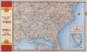
Shell Highway Map Southeastern Section of the United States.
1 : 3231360 Shell Oil Company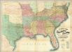
Lloyd's Map Of The Southern States.
1 : 2027520 Lloyd, J. T.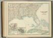
United States of North America (South East Sheet).
1 : 3984000 Johnston, W. & A.K.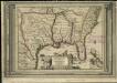
La Floride, suivant les nouvelles observations de Messrs. de l'Academie des Sciences, etc.
1 : 9000000 Aa, Pieter van der
Southern Section of the United States including Florida.
1 : 3928320 Melish, John
Southern Section of the United States including Florida.
1 : 3928320 Melish, John
The Historical War Map.
1 : 3294720 Russell, Benjamin B.
La Floride: suivant les nouvelles observations de Messrs. de l'Academie royale des sciences, etc. augmentées de nouveau. / A Leide, Chez Pierre Vander A.A., avec privilege.
from John H. Levine Collection Pierre Vander A.A.,
A map of the states of Virginia, North Carolina, South Carolina and Georgia : comprehending the Spanish provinces of east and west Florida : exhibiting the boundaries as fixed by the late treaty of peace between the United States and the Spanish dominions
1 : 6336000 This map depicts the fixed boundaries by a peace treaty between the United States and the Spanish Dominions. Purcell, Joseph John Stockdale
Etats Unis Flle. S.E.
1 : 5000000 Vivien St Martin, L.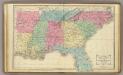
Southern U.S.
1 : 3500000 Cornell, S. S. (Sarah S.)
N. & S. Carolina.
1 : 6300000 Grigg, John
Piedmont Air Line.
1 : 11900000 Piedmont Air Line Railroad Company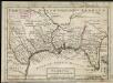
Florida called by ye French Louisiana &c.
1 : 150000 Moll, Herman Bowles, Thomas
Lloyd's Map of the Southern States
Lloyd's Map of the Southern States showing all the Railroads, their Stations and Distances, also the Counties, Towns, Villages, Harbors, Rivers & Forts. This map was published by J.T. Lloyd in New York in 1861. It details ‘all the railroads, their stations & distances’, as well as the ‘counties, towns, villages, harbors, rivers and forts’ based on the ‘latest Government and other reliable sources’. The map details states beneath the Mason-Dixon line which theoretically separated the northern and southern states. As well as showing the states that made up the eastern side of the Confederacy, the map also shows the Union states of Kentucky, Maryland and Delaware, which, along with Missouri, made up the Border States. Maintaining these states within the Union was a crucial war aim for Lincoln. J.T. Lloyd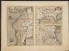
La Florida. Auctore Hieron Chiaves.
When first issued in 1584 as a copper engraving by Ortelius in his Theatrum Orbis Terrarum 1584-1612, this was one of the few sixteenth century maps based on Spanish sources; in this case drawn from reports of Hernando de Soto's expedition through the region. There are three maps on this sheet. The most important map (La Florida) is the first printed map of the southeastern portion of the United States. This influential map provided the foundation cartography for the region, particularly in the depiction of the river system. The map below (Guastecan Reg) combines with La Florida to extend the coastline of the Gulf of Mexico further south. The third is a map of Peru, where De Soto was the first Spaniard to meet Inca Emperor Atahuallpa. In the north of the map of Peru is Aurea Regio, or Kingdom of Gold, a reference to the fabled El Dorado. Text on verso. Chaves, Geronimo, 1523-1574.;Ortelius, Abraham, 1527-1598. Ortelius, Abraham, 1527-1598.