Maps of Brandenburg

Brandenburg, W. Pomerania.
1 : 660000 Robert Laurie & James Whittle
Marchionatus Brandenburgicus
1 : 673000 Braniborsko (Německo) Örnehufvud, Olof Hansson Blond, Michael H. Hondius
Übersichtskarte von Mittel - Europa
Stettin
1 : 600000 Opitz, Carl Solbrig
Marchia Media; Vulgo Mittel Marck in March: Brandenb: [Karte], in: Novus atlas absolutissimus, Bd. 2, S. 60.
1 Karte aus Atlas Janssonius Offizin
Lübeck, Stralsund, Stettin
1 : 750000 Lübeck (Německo : oblast) Lorenz, K. K. u. k. Militärgeographisches Institut
Lübeck, Stralsund, Stettin
1 : 750000 Lübeck (Německo : oblast) K. k. militär-geographisches Institut
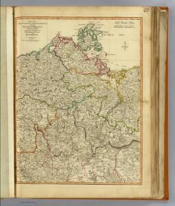
Preussische Provinz Brandenburg
1 : 540000 Berlín-oblast (Německo) Gräf, Adolf Biedermann, E. Geographisches Institut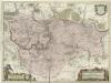
March. Brandenburgici Pars, quae Marchia Media Vulgo Mittesmarck audit
1 : 400000 Mollova mapová sbírka Wit, Frederik de Covens, Johannes I
Marchia Media Vulgo Mittel Marck in March: Brandenb:
1 : 500000 Mollova mapová sbírka Valk, Gerhard Schenk, Peter I
Marchia Media Vulgo Mittel Marck in March: Brandenb:
1 : 510000 Mollova mapová sbírka Janssonius, Johannes Janssonius, Johannes I
[Operationen der alliirten und französischen Armee 1759]

Berlin Varta Wegweiser

[Rügen und Umgebung]
1 : 285000 Polsko severozápadní Engelhardt, F. B. Bembe Simon Schropp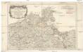
Nouvelle carte de la Pomeranie occidentale et de l'electorat de Brandebourg
1 : 790000 Braniborsko (Německo) Rizzi Zannoni, Giovanni Antonio Julien, Roch Joseph Julien
Rugiae, Usedomiae, Et Iulinae, Wandalicarum insularum vera descriptio. [Karte], in: Theatrum orbis terrarum, S. 209.
1 Karte aus Atlas Ortelius, Abraham Vrients, Jan Baptista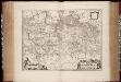
March. Brandenburgici pars, quae Marchia Media vulgo Mittelmarck audit
1 : 400000 Annotatie: Origineel is Blad 91 in atlas factice; Annotatie geografische gegevens: Met schaalstok: Milliaria Germanica Joan Blaeu 1597/98-1673 Amstelaedami : excud. Joannes Blaeu
MARCH. BRANDENBURGICI | PARS, quæ | MARCHIA MEDIA | Vulgo MITTELMARCK audit.
Amstelædami, | Excud. Joannes Blaeu.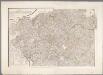
Karte des Herzogthums Mecklenburg mit seinen verschiedenen Provinzen ... / durch F.W.C. Grafen von Schmettau
1 : 250000 Schmettau, F. W. C. von Berlin : [s.n.]
Brandebvrgvm Marchionatvs cum Ducatibus Pomeraniae et Mekelenbvrgi
1 : 1100000 Mollova mapová sbírka Merian, Matthäus Merian, Matthäus - dědici
Pomeraniae Dvcatvs Tabvla
1 : 1100000 Mollova mapová sbírka Merian, Matthäus Merian, Matthäus - dědici
[Berlin und Umgebung; Die Donau von Paussau bis Wien mit Umgebung]
Stieler's Hand-Atlas Stieler, Adolf bei Justus Perthes
Straßen in den Mecklenburgischen Herzogtümern 1848 (Auswahl)
Mecklenburg Straßennetz Kunz, Andreas ; Treiling, Thomas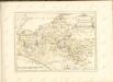

[Die Grossherzogthümer Mechlenburg Schwerin und Strelitz]
Grosser Hand-Atlas über alle Theile der Erde in 170 Karten Meyer, J. Verlag des Bibliographischen Instituts
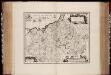
MARCHIONATUS | BRANDENBURGICI | PARTES DUÆ, | NOVA MARCHIA | et | UCKERANA
Auctore | OLAO JOANNIS GOTHO | Gustaui Magni Cosmographo. [Amsterdam : Joan Blaeu]
Il Dvcato di Meklenbvrgo
1 : 450000 Mollova mapová sbírka Cantelli, Giacomo De Rossi, Domenico
Die Grosshezogthümer Meklenburg-Schwerin und Meklenburg-Strelitz
1 : 370000 Meklenbursko (Německo) Gräf, C. Luther, Th. Geographisches Institut
Mapa Wojewodztwa Szczecinskiego