Maps of Belgium
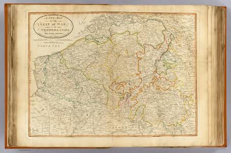
Seat of war Netherlands.
1 : 630000 Robert Laurie & James Whittle
Circvlvs Bvrgvndicvs
1 : 732700 Belgie Mayer, Tobias Cassini de Thury Homannianis heredib.
Belgivm catholicvm seu Decem provinciae Germaniae inferioris
1 : 732700 Belgie Mayer, Tobias Cassini de Thury Homannianis heredib.
Pays Bas meridionale.
1 : 970000 Janvier, Jean
Belgium Catholicum seu Decem Provinciae Germaniae Inferioris...
Pays Bas Catholoques.
1 : 700000 L'Isle, Guillaume de, 1675-1726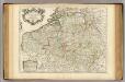
Pays Bas Catholoques.
1 : 700000 L'Isle, Guillaume de, 1675-1726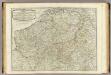
The Catholic Netherlands.
1 : 630000 Kitchin, Thomas
Carte des Pais Bas Catholiqves ou des X Provinces de l'Allemagne Inferieure etc. dessinée au juste selon les exactes observations Astronimiques et Operations Geometriques des Mess. Cassini. Snelius. Muschenbrok etc. dresée par Sr. Tobias Maier. Mathematicien
1 : 725000 Mollova mapová sbírka Mayer, Tobias Homann, Johann Baptista - dědici
The theatre of the present war in the Netherlands : being an improvement of a large map of the Low Countries by Mr. La Rouge : with the addition of the adjacent parts of England, Germany and the United Provinces
1 : 350000 Annotatie: Met plaatsnamenregister (met coördinaten en afstanden t.o.v. Londen, Parijs en Den Haag) London : printed for R. Wilkinson ... and Bowles & Carver
Les Provinces des Pays-Bas Catholiques [...] [Karte], in: Atlas nouveau, contenant toutes les parties du monde [...], Bd. 2, S. 20.
1 Karte aus Atlas Sanson, Nicolas Jaillot, Alexis Hubert und Mortier, Pieter
Provinces des Pais Bas
1 : 800000 Mollova mapová sbírka Fer, Nicolas de Starckman, P. Fer, Nicolas de
Belgium Regium divisum in decem provincias, nempe ducatus Brabantiae, Limburgi, Lucisburgi, Geldriae ; comitatus Flandriae, Artesiae, Namurci, Hannoniae, Marchionatum Antverpiae, Imperium Machliniensis, ceterasque adsitas regiones delineatum
1 : 650000 per Gerardum et Leonardum Valk [Amsterdam] : Gerard et Leonard Valk
Nieuwe en naukeurige kaart der tien catholijke Nederlanden, uit de beste autheuren en beroemste heedendaagsche kaarten opgemaakt, en volgens sterekundige waarnemingen in orde gebragt
1 : 850000 door Eman. Bowen verb. door W.A. Bachiene ; J. v. Jagen fecit, 1775 [Amsterdam] : [Matthijs Schalekamp]

Des Burgundischen Creisses Südlicher theil oder Oesterreichissche Niederlande
1 : 2250000 Mollova mapová sbírka Weigel, Christoph Weigel, Christoph I. - dědici
Belgivm Regivm accuratissime descriptum
1 : 1200000 Mollova mapová sbírka Weigel, Christoph Kauffer, Michael Weigel, Christoph I.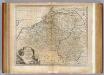
Netherlands or Low Countries.
1 : 980000 Bowen, Emanuel
Belgium Regium Accuratissime Divisum. &c: Ad Usum Serenissimi Burgundiae Ducis. Authore G. de l'Isle, Geographe
1 : 710000 Mollova mapová sbírka Delisle, Guillaume Luchtenburg, Johannes van Covens, Johannes I
Arena Martis in Belgio
1 : 830000 Mollova mapová sbírka Homann, Johann Baptist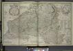
Les provinces des pays-bas Catholiques, ou a most exact map of Flanders or Austrian Netherlands &c.
from The world described, or, A new and correct sett of maps : shewing the kingdoms and states in all the known parts of the earth, with the principal cities, and most considerable towns in the world ... / ... by Herman Moll, geographer ...
BELGII REGII accuratissima Tabula
1 : 810000 Belgie Visscher, Nicolaus Nicolao Visscher
Germaniae inferioris sive Belgii pars meridionalis
1 : 853800 Belgie Lotter, Tobias Conrad M. Tob Conr. Lotter
Germaniae inferioris sive Belgii pars meridionalis
1 : 853800 Belgie Lotter, Tobias Conrad M. Tob Conr. Lotter
Pays-Bas Catholiques, Luxembourg.
1 : 630000 Robert de Vaugondy, Gilles, 1688-1766
Belgii Regii accuratissima Tabula. [Karte], in: Novus atlas absolutissimus, Bd. 3, S. 25.
1 Karte aus Atlas Janssonius Offizin
XXIII Tableau, uit: Carte chorographique des Pays-Bas Autrichiens / ... par le Comte de Ferraris ; gravée par L.A. Dupuis
1 : 86400 Annotatie: Lit.: Les militaires et la cartographie des Pays-Bas méridionaux et de la Principauté de Liège à la fin du XVIIe et au XVIII siècle / Claire Lemoine-Isabeau. - Bruxelles, 1984, p. 206-212; La cartographie au XVIIIe siècle et l'oeuvre du Comte de Ferraris (1726-1814) : colloque international, Spa, 8-11 sept. 1976. - Bruxelles, 1978; Met opdracht aan keizer Joseph II (bl.XVI); Met plattegrond van Brussel (bl. XXI), overzichtskaart (bl. XXII) en bladwijzer (bl. XXIII); Ontbreekt: bl. I-III en XXI; Voor aanwezige bladen zie overzichtsblad Ferraris, Johann Joseph; Dupuis, L. A. [S.l. : s.n.]
Arena martis in Belgio, qua provinciae X. catholicae inferioris Germaniae
1 : 850000 Belgie Homann, Johann Baptist J. B. Homann
Les Provinces des Pays-Bas Catholiques distinguées suivant qu'elles sont presentement partagées entre le Roy de France le Roy d'Espagne et les Estats Generaux des Provinces Vnies
1 : 680000 Mollova mapová sbírka Cordier, Louis Jaillot, Alexis Hubert