Maps of Bangka-Belitung Islands
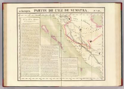
Partie, Sumatra. Oceanique no. 19.
1 : 1641836 Vandermaelen, Philippe, 1795-1869
New chart of the straits of Sunda, Banca, Gaspar and Billiton
1 : 110000 drawn from the best authorities, by J. W. Norie, Hydrographer, &c. J. Stephenson, engraver London : Norie
Geologische overzichtskaart van den Nederlandsch Oost-Indischen Archipel : Billiton, Zuidwest-Borneo Blad 1X / bewerkt door L.J.C. van Es Jr
Landsdrukkerij Batavia Weltevreden : Landsdrukkerij
Banca and Gaspar straits (1958)
Banca and Gaspar Straits. Mintok Bay, etc. [Admiralty Chart]
Pontianak / samengesteld en gedrukt bij den Topografischen Dienst
Topografische Dienst Batavia Batavia : Topografische Dienst
Pontianak / U.S. Army Map Service
U.S. Army Map Service Washington D.C. Washington D.C. : U.S. Army Map Service
Algemeene schetskaart van Nederlandsch-Indië : Gouv[ernement] Borneo : Res[identie] Zuider- en Oosterafd[eeling] v[an] Borneo / Topografische Dienst, Batavia
[S.l. : s.n.]
[Kaart van Straat van Sunda]
[S.l. : s.n.
Palembang / Survey of India
Survey of India [S.l.] : Survey of India
Palembang / samengesteld en gedrukt bij den Topografischen Dienst
Topografische Dienst Batavia Batavia : Topografische Dienst
Geologische overzichtskaart van Bangka en Billiton
Amsterdam : Joh. G. Stemler
Pangkal Pinang / Survey of India
Survey of India [S.l.] : Survey of India
Kendawangan / Survey of India
Survey of India [S.l.] : Survey of India
Teloekbetoeng / Survey of India
Survey of India [S.l.] : Survey of India
Kaart van den Archipel van Riouw, Singapore en Lingga [and] Kaart van de eilanden Bangka en Blitong
D. Heyse, graveur lith. te 's Hage ; gedr. bij P. Blommers te 's Hage te 's Hage : uitgave van K. Fuhri
A map of the island of Banca
1 : 200000 by M. H. Court R. Baily sculpt. London : Black, Kingsbury, Parbury & Allen
Kaart van den Riouw- en Lingga-Archipel / [J.W. Stemfoort en J.J. ten Siethoff ; gereproduceerd op last van het Departement van Koloniën, aan de Topographische Inrichting te 's-Gravenhage, onder leiding van den Directeur C.A. Eckstein]
Ministerie van Koloniën Den Haag s-Gravenhage : Departement van Koloniën
11. [Bangka, Blitoeng, Riouw- en Lingga-Archipel], uit: Atlas van Nederlandsch Oost-Indië / samengest. door Topographisch Bureau te Batavia van 1897-1904
Annotatie: Omgewerkte versie van: Atlas der Nederlandsche bezittingen in Oost-Indië / naar de nieuste bronnen samengest. door J.W. Stemfoort en J.J. ten Siethoff. - 's-Gravenhage : Topographische Inrichting, [ca. 1885] Topographisch Bureau, Batavia 's-Gravenhage : Topographische Inrichting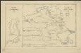
Het eiland Banka, 1819 [and] De rivier van Palembang, 1821
1 : 650000 Amsterdam : Wed. G. Hulst van Keulen
Schets-taalkaart van de Residentie Bangka / samengesteld door K.F. Holle, Adviseur-Honorair voor Inlandsche Zaken, naar gegevens verstrekt door de ambtenaren van Binnenlandsch Bestuur en met medewerking van het Topographisch Bureau te Batavia
Batavia : Topographisch Bureau
Res[identie] Bangka en Onderh[oorigheden] / Topografische Dienst, Batavia
[S.l. : s.n.]
Geologische kaart van Bangka / naar de opnemingen der mijningenieurs en eigen onderzoekingen samengesteld door R.D.M. Verbeek
Amsterdam : Joh. G. Stemler
Pontianak / Survey of India
Survey of India [S.l.] : Survey of India
Belinjoe / Survey of India
Survey of India [S.l.] : Survey of India
Banka : overzichtskaart der alluviale tinertsafzettingen en van de wegen / aut. C.J. van Doorne
[S.l. : s.n.]
[Bangka]
Topografische Dienst Batavia Batavia : Reproductiebedrijf Topografische Dienst
[Menggala]
Topografische Dienst Batavia Batavia : Reproductiebedrijf Topografische Dienst
Marga-indeeling Residentie Lampongsche Districten
[S.l. : s.n.]
Residentie Lampongse Districten / bewerkt door het Encyclopaedisch Bureau
Encyclopaedisch Bureau Batavia Welt[evreden] (Batavia) : Top[ografische] Inr[ichting]