Maps of Kepulauan Riau
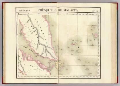
Presqu'ile de Malacca. Oceanique no. 12.
1 : 1641836 Vandermaelen, Philippe, 1795-1869
Geologische overzichtskaart van het schiereiland Malakka en omgeving = Geological map of British Malaya / J.B. Scrivenor
Landsdrukkerij Batavia [Weltevreden (Batavia) : Landsdrukkerij]
Singapore / Survey of India
Survey of India [S.l.] : Survey of India
British Possessions In The Indian Seas.
Fullarton, A. & Co.
Anambas Eilanden / Survey of India
Survey of India [S.l.] : Survey of India
Tambelan Eilanden / Survey of India
Survey of India [S.l.] : Survey of India
Strait of Singapore / Survey of India
Survey of India [S.l.] : Survey of India
Kaart van een gedeelte van Sumatra's Oostkust
Aardrijkskundig Genootschap Amsterdam Amsterdam : C.L. Brinkman
[P[oelau] Roepat]
Topografische Dienst Batavia Batavia : Reproductiebedrijf Topografische Dienst
[Batam]
Topografische Dienst Batavia Batavia : Reproductiebedrijf Topografische Dienst
[Malaka]
Topografische Dienst Batavia Batavia : Reproductiebedrijf Topografische Dienst
Riouw Archipelago : 1 inch to 1 mile / S[u]rv[e]y Directorate H[ead] Q[uarters] ALFSEA
[S.l. : s.n.]
[Lingga-Archipel]
Topografische Dienst Batavia Batavia : Reproductiebedrijf Topografische Dienst
Figurative kaart van een gedeelte van Sumatra voornamelijk aantoonende de wegen en rivieren, welke uit de Padangsche binnenlanden naar de oostkust afloopen
1 : 1360000 opgenomen door S. Muller en H. Hellbach steendr. van H.J. Backer Amsterdam : Beyerinck
Schets-taalkaart van den Riouw- en Lingga-Archipel / samengesteld door K.F. Holle, Adviseur Honorair voor Inlandsche Zaken, naar gegevens vertrekt door de ambtenaren van Binnenlandsch Bestuur en met medewerking van het Topographisch Bureau te Batavia
Topographische Inrichting Batavia [Batavia] : Top[ographische] Inrichting
Pakanbaroe / Survey of India
Survey of India [S.l.] : Survey of India
[Pakanbaroe]
Topografische Dienst Batavia Batavia : Reproductiebedrijf Topografische Dienst
Poeak / published by War Office = uitgegeven door War Office ; revised and photolithographed by War Office
War Office Washington D.C. [Washington D.C.] : War Office
Tandjoengpinang / published by War Office = uitgegeven door War Office ; revised and photolithographed by War Office
War Office Washington D.C. [Washington D.C.] : War Office
Koendoer / published by War Office = uitgegeven door War Office ; revised and photolithographed by War Office
War Office Washington D.C. [Washington D.C.] : War Office
Singapore / published under the direction of the Chief of Engineers U.S. Army by the Army Map Service
Army Map Service U.S. Army Washington D.C. Washington D.C. : Army Map Service
Gouv[ernemen]t Sumatra : Res[identie] Riouw / Topografische Dienst, Batavia
[S.l. : s.n.]
Port Dickson / prepared under the direction of the Chief of Engineers U.S. Army ; by the Army Map Service
Army map Service U.S. Army Washington D.C. [Washington D.C.] : Army Map Service
Bengkalis / published by War Office = uitgegeven door War Office ; revised and photolithographed by War Office
War Office Washington D.C. [Washington D.C.] : War Office
Siak Sri Indrapoera / published by War Office = uitgegeven door War Office ; revised and photolithographed by War Office
War Office Washington D.C. [Washington D.C.] : War Office
Pakanbaroe / published by War Office = uitgegeven door War Office ; revised and photolithographed by War Office
War Office Washington D.C. [Washington D.C.] : War Office
Lagoi / published under the direction of the Chief of Engineers U.S. Army by the Army Map Service
Army Map Service U.S. Army Washington D.C. Washington D.C. : Army Map Service
Kaart van den Battam-archipel en Kateman / door J.G. Schot
[Amsterdam : De Bussy]
Terempah / samengesteld door den Topografischen Dienst (Kartogr[afische] Afd[eeling]) naar diverse gegevens in 1941
Topografische Dienst Batavia Batavia : Reproductiebedrijf Topografische Dienst