Maps of Maine
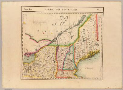
Partie des Etats-Unis. Amer. Sep. 43.
1 : 1641836 Vandermaelen, Philippe, 1795-1869
Map of Oswego Co.
from New topographical atlas of Oswego County, New York : from actual surveys especially for this atlas.
New England and New York.
1 : 3000000 Lloyd, H.H.
New England and New York.
1 : 3000000 Walling, H. F.
Nova Anglia Septentrionali Americae implantata Anglorumque coloniis florentissima geographicè exhibita

Scene of Operations of the Northern Army.
1 : 1950000 Marshall, John
101. Consumption NY, NJ, New England.
1 : 3000000 Gannett, Henry, 1846-1914; United States. Census Office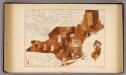
109. Typhoid fever NY, NJ, New England.
1 : 3000000 Gannett, Henry, 1846-1914; United States. Census Office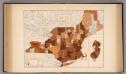
105. Diphtheria, croup NY, NJ, New England.
1 : 3000000 Gannett, Henry, 1846-1914; United States. Census Office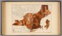
107. Influenza NY, NJ, New England.
1 : 3000000 Gannett, Henry, 1846-1914; United States. Census Office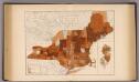
103. Cancer, tumor NY, NJ, New England.
1 : 3000000 Gannett, Henry, 1846-1914; United States. Census Office
An accurate map of the State and Province of New-Hampshire in New England : taken from actual surveys of all the inhabited part, and from the best information of what is uninhabited, together with the adjacent countries, which exhibits the theatre of this war in that part of the world
1 : 633600 Sawyer, Abel [s.n.]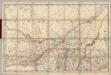
(Quebec, New England) Railroad Map of the United States.
1 : 506880 Rand McNally and Company
Maine, New Hampshire, Vermont, Massachusetts, Connecticut & Rhode Island.
1 : 1140480 Tanner, Henry S.
Map Of The States Of Maine, New Hampshire, Vermont, Massachusetts, Connecticut & Rhode Island.
1 : 1140480 Tanner, Henry S.
Maine, New Hampshire, Vermont, Massachusetts, Connecticut & Rhode Island.
1 : 1140480 Tanner, Henry S.
Maine, New Hampshire, Vermont, Massachusetts, Connecticut & Rhode Island.
1 : 1140480 Tanner, Henry S.
Maine, New Hampshire, Vermont, Massachusetts, Connecticut & Rhode Island.
1 : 1140480 Tanner, Henry S.
Map of the New York Central & Hudson River and Boston & Albany Railroads

Nova Anglia Septentrionali Americae implantata Anglorumque coloniis florentissima / geographice exhibita â Ioh. Baptista Homann, sac. caes. maj. geographo.
from John H. Levine Collection John Baptista Homann, S.,
Map of Maine, New Hampshire, and Vermont : compiled from the latest authorities
1 : 1001000 Young, J. H. (James Hamilton) S. Augustus Mitchell
Parcel post map of the United States
1 : 7800000 L.L. Poates Engr'g Co. L.L. Poates Engr'g Co.
Map of New England with adjacent portions of New York & Canada
1 : 1537500 Walling, Henry Francis Walling, Henry Francis
New England And Lower Canada.
1 : 1520640 Johnson, A.J.
A map of the New England states : Maine, New Hampshire, Vermont, Massachusetts, Rhode Island & Connecticut, with the adjacent parts of New York & lower Canada
1 : 506880 Hale, Nathan, 1784-1863 Nathan Hale
Map of New England with adjacent portions of New York & Canada
1 : 1537500 Walling, Henry Francis Walling, Henry Francis
Carte du theatre de la guerre entre les Anglais et les Américains; dressée d'aprés les cartes anglaises les plus modernes / par M. Brion de la Tour, ingénieur-géographe du roi.
from Revolutionary War, 1775-1783 M. Bellin,
New England.
1 : 2100000 Mitchell, Samuel Augustus
Map of the New England or Eastern States.
1 : 3000000 Mitchell, Samuel Augustus