Maps of King Wilhelm Land
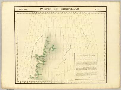
Partie du Groenland. Amer. Sep. 4.
1 : 1641836 Vandermaelen, Philippe, 1795-1869
Carte d'Europe ou sont tracées les limites des empires, royaumes, et etats souverains, feuille 1
1 Blatt : 63 x 96 cm Semen etc
Feuille 2 (B I), uit: Carte géologique internationale de l'Europe : la carte, votée au congrès géologique international de Bologne en 1881, est exécutée conformément aux décisions d'une commission internationale, avec le concours des gouvernements, sous le dir. de M.M. Beyrich et Hauchecorne
Annotatie: Blad 48 gamme des couleurs; blad 49: bladwijzer en titelblad Heinrich Ernst Beyrich 1815-1896; Wi. Hauchecorne Berlin : Reimer / (Berlin: Institut lithographique)
Gletscherkarte.
Berghaus, Hermann
De custen van Noorwegen, Finmarken, Laplandt, Spitsbergen, Ian Maÿen Eÿlandt, Yslandt, als mede Hitlandt, en een gedeelte van Schotlandt
1 Karte : Kupferdruck ; 44 x 54 cm Doncker bÿ Hendrick Doncker boeckverkoper in de Nieubrugsteeg
Vorstellung des Meers in Norden von Asien und America, nebst der Berechnung von dessen Grösse und Ausdehnung
Asie severní
Scandinavia.
1 : 9300000 Bowen, Emanuel
Carte marine, de la B. de Baffin, et une partie d'Hudson, d'Island et Groenland
1 Karte : Kupferdruck ; 42 x 48 cm Königliche Akademie der Wissenschaften
Gletscherkarte
Atlas der Geologie Zittel, K.v. ; Berghaus, Hermann Justus Perthes
A General Chart ... Davis Straits & Baffin Islands Bay.
1 : 19000000 Melish, John
Groenland und die angraenzenden Laender nach den Charten und Berichten von Cranz, Egede, Gieseke, Graah, Olavsen, Parry, Ross, Scoresby, Thorhallesen u.a.
1 : 5000000 entworfen und gezeichnet von Theodor Gliemann Weimar : Verlag des Geograph. Instituts
Pas-caerte van Groenlandt, Yslandt, Straet Davids en Ian Mayen Eylant
1 Karte : Kupferdruck ; 43 x 52 cm Doncker bÿ Hendrick Doncker boekverkoper en graadbooghmaker inde Nieubrughsteegh
North America...N.E. Sheet.
1 : 7500000 Tanner, Henry S.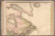
North America...N.E. Sheet.
1 : 7500000 Tanner, Henry S.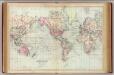
World, Mercator's projection.
1 : 68000000 Asher & Adams
Sweden, and Norway.
from A system of geography, or, A new & accurate description of the earth in all its empires, kingdoms and states : illustrated with history and topography, and maps of every country : fairly engraven on copper, according to the latest discoveries and corrections / by Herman Moll.
Carte réduite des mers du Nord
1 Karte : Kupferdruck ; 31 x 42 cm Bellin Didot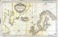
Carte réduite des mers du Nord
1 Karte : Kupferdruck ; 51 x 84 cm s.n.
185-186. North Canada, Greenland. The World Atlas.
1 : 7500000 USSR (Union of Soviet Socialist Republics).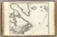
Amerique Septentrionale 2.
1 : 7500000 Brue, Adrien Hubert, 1786-1832
Canada - East. Pergamon World Atlas.
1 : 10000000 Polish Army Topography Service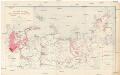
Sovetskaja Arktika
1 : 6000000 Arktida Atlasov, I.P. Glavsevmorput'

Itinéraires du yacht "Princesse Alice" dans l'Océan atlantique nord, dans la Méditerranée et dans l'Océan glacial arctique, de 1891 a 1899
Atlantský oceán Tollemer, A. Imprimerie Vieillemard
Europe.
1 : 27000000 Carey, Mathew
Europe.
1 : 28000000 Carey, Mathew

Canada, Alaska.
1 : 1584000 Smith, J. Calvin