Maps of Tohoku
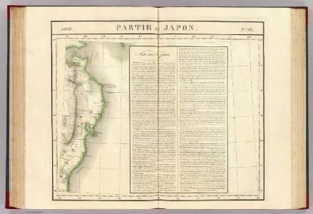
Partie du Japon. Asie 62.
1 : 1641836 Vandermaelen, Philippe, 1795-1869
Ônuma, Konuma, Zyunsai-numa
1 : 20000 Hokkaidó (Japonsko : ostrov)
Decouvertes nord du Japon.
1 : 2800000 Vries, Maarten Gerritszoon
Tôhoku-Tihô Si-Tyô-Son betu Zinkô-Mitudo-Du
1 : 800000 Japonsko Saitô gratitude foundation
The automobile map
1 : 500000 Japonsko Nippon automobile club
[Kaart], uit: Ezo kōkyō yochi zenzu
1 : 1200000 Edo : Harimaya Katsugorō
[Map of Japan]
1 : 1
Map of the Japan Islands
1 : 7000000 Maury, William L J. Ackerman
Kaart van Japan / [getekend door] R. van Wijk
Dordrecht : J. de Vos
Kaart van Japan : behoorende tot de, door het Provinciaal Utrechtsch Genootschap bekroonde Verhandeling van R.G. Bennet en J. van Wyk Rz.
1 : 4500000 R. van Wyk Jz. del. Te Dordrecht : by J. de Vos & Co.
Nova Et Accurata Iaponiae, Terrae Esonis, ac Insularum adiacentium. ex Novißimâ detectione descriptio. [Karte], in: Novus atlas absolutissimus, Bd. 6, S. 139.
1 Karte aus Atlas Janssonius Offizin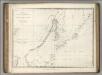
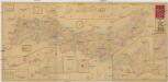
Chart of Discoveries, Made in 1787, in the Seas of China and Tartary, Sheet II.
1 : 6050000 La Perouse, Jean-Francois de Galaup, comte de, 1741-1788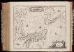
Nova et accvrata Iaponiæ, Terræ Esonis ac insularum adjacentium ex novißima detectione descriptio
1 : 5000000 Annotatie: Beschreven in: Koeman, Atlantes Neerlandici II, p. 443-444; Zeekaart; Origineel is Blad 198 in atlas factice; Annotatie geografische gegevens: Schaalstok, verlopend over 32o tot 50o van 42 Milliaria Germanica Johannes Janssonius 1588-1664 [Amstelodami : Apud Ioannem Ianßonium]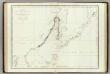
Mers, Chine, Tartarie. 2.
1 : 6250000 La Perouse, Jean-Francois de Galaup, comte de, 1741-1788
Japan, Mandshuria (showing the course of the Amur river), the Kurile Isles &c. : according to the British & Russian Admiralty surveys, Krusenstern, Siebold &c. / by J. Bartholomew Jun.r ; engraved by J. Bartholomew
1 : 9000000 titelvariant: Islands of Japan; Annotatie: Uit: The Royal illustrated atlas of modern geography. - London [etc.] : A. Fullarton & Co., 1860; Lit: A list of geographical atlases, I, no. 838; Titel boven de kaart: Islands of Japan Bartholomew, John (1831-1893) Edinburgh [etc.] : A. Fullarton & Co.
JAPON

JAPON
Shinsen Dainihon Zenzu
1 : 2200000 Japonsko Sagano, Hikotaro Sagano Hikotaro
Chart of the Discoveries to the North of Japan, in 1643.
La Perouse, Jean-Francois de Galaup, comte de, 1741-1788
Asie

Japan and Korea.
1 : 6198300 Johnston, W. & A.K.
Empire of Japan.
1 : 4100000 Bowen, Emanuel
Japan. Coal Resources of the World.
1 : 5000000 McInnes, William; Leach, W.W.; Dowling, D.B.
Impero del Giappone.
1 : 4450000 Society for the Diffusion of Useful Knowledge (Great Britain)
Karte von Jesso und Sagalien
Hokkaidó (Japonsko)
Japan. Nippon, Kiusiu, Sikok, Yesso and the Japanese Kuriles.
1 : 4000000 Colton, G.W.
Bojiště rusko-japonské ve východní Asii
1 : 4500000 Japonsko Kotrba, V.
Bojiště rusko-japonské ve východní Asii
1 : 4500000 Japonsko
123-124. Japan. The World Atlas.
1 : 2500000 USSR (Union of Soviet Socialist Republics).