Maps of Brandenburg

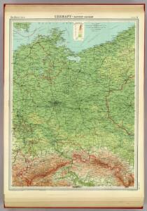
Germany - eastern section.
1 : 1000000 John Bartholomew and Son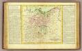
Haute Saxe.
1 : 1900000 Clouet, J. B. L. (Jean-Baptiste Louis), b. 1730
Upper Saxony.
1 : 2900000 Bowen, Frances
General Karte von denen Ober- und Niedersaechsischen Kreisen nach des D. Büsching Erdbeschreibung u. den besten Hülfsmitteln entworffen
1 : 1150000 [Augsburg] : bey Joh. Walch
L'Empire, d'Allemagne
1 : 1200000 Mollova mapová sbírka Sanson, Nicolas Quasy, Robert

[Nord-Östliches Deutschland]
Hand-Atlas über alle Theile der Erde nach dem neuesten Zustande und über das Weltgebäude Stieler, Adolf bei Justus Perthes
Le Cours de l'Elbe et de l'Oder où sont les Electorats de Saxe et de Brandebourg, les Duchés de Mekelbourg et de Pomeranie
1 : 1400000 Mollova mapová sbírka Duval, Pierre Duval, Pierre
[Nordoestliches Deutschland]
Stieler's Hand-Atlas Stieler, Adolf bei Justus Perthes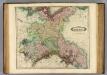
Upper Saxony.
1 : 1500000 Lizars, Daniel
Postkarte von dem Obersaechsischen und Niedersaechsischen Kreise
Polsko severozápadní Kühn, Ignaz im von Reilly'schen Landkarten und Kunstwerke Verschleiss Komptoir
Brandenburg und Pommern
1 : 1151000 Braniborsko (Německo) Jättnig, Wilhelm Gleditsch
[Die Provinzen Brandenburg, Pommern und Sachsen, nebst Anhalt und Mecklenburg]
Schul-Atlas in 36 Karten Völter, Daniel Verlag der J.M. Dannheimer'schen Buchhandlung
Prehľadná automapa NDR

Mitteldeutschland
Volksschul-Atlas über alle Teile der Erde Lange, Henry Druck und Verlag von Georg Westermann
A map of Upper Saxony comprehending that part of Germany which is the present seat of war
1 : 2534400
The eastern front
1 : 2280000 Shows railways, main highways, and the Front as of Feb. 12-19 (1945.). "Restricted." "No. 6180 - R & A, OSS. 20 February 1945." United States. Office of Strategic Services. Research and Analysis Branch. [Washington, D.C.] : Lithographed in Reproduction Branch, OSS
Karte der Mark Brandenburg und des Herzogthums Pommern
Neuester Schul-Atlas Walch, Johann im Verlag bei Joh. Walch
Brandenburg und Pommern
Allgemeiner Atlas [Walch, Johannes] im Verlag bei Johannes Walch
Tabula Marchionatus Brandenburgici et Ducatus Pomeraniae quae sunt Pars Septentrionalis Circuli Saxoniae Superioris novissime edita
1 : 1000000 Mollova mapová sbírka Homann, Johann Baptist Homann, Johann Baptista
La Pomerania divisa in Citeriore, o Reale che spetta alla Corona di Suezia et in Vlteriore , o Ducale che appartiene all ́Elettore di Brandeburgo e Subdiuisa nelle Parti Principali, che la compognono
1 : 700000 Mollova mapová sbírka Cantelli, Giacomo De Rossi, Giovanni Giacomo
Charte über den nördlichen Theil des ober saechsischen Kreises enthaltend die Mark Brandenburg u. d. Hrz. Pom[m]ern
1 Karte : Kupferdruck ; 46 x 59 cm Güssefeld im Verlage des Industrie Comptoirs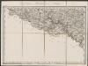
Marca Brandenburgensis & Pomerania. [Karte], in: Gerardi Mercatoris Atlas, sive, Cosmographicae meditationes de fabrica mundi et fabricati figura, S. 394.
1 Karte aus Atlas Mercator, Gerhard Montanus, Petrus
Der nördliche Theil des Ober Sächsischen Kreises oder die Mark Brandenburg und das Herzogthum Pommern
1 : 880000 Braniborsko (Německo) Güssefeld, Franz L. von den Homan[n] Erben
Der nördliche Theil des Ober-Sächsischen Kreises oder die Mark Brandenburg und das Herzogthum Pommern
1 : 880000 Braniborsko (Německo) Güssefeld, Franz L. Schmidt, I.M. von den Homann. Erben
Der nördliche Theil des Ober Sächsischen Kreises oder die Mark Brandenburg und das Herzogthum Pommern
1 : 880000 Braniborsko (Německo) Güssefeld, Franz L. von den Homan[n] Erben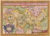
Brandeburgensis Marchae Descriptio. [Karte], in: Theatrum orbis terrarum, S. 141.
1 Karte aus Atlas Ortelius, Abraham
Marchionatus Brandenburgi et Ducatus Pomeraniae Tabula Quae est pars Septentrionalis Circuli Saxoniae Superioris
1 : 1000000 Mollova mapová sbírka Wit, Frederik de Wit, Frederick
Marchionatus et Electoratus Brandeburgicus, una et Ducatus Pomeraniae in suas subdivisi Ditiones Atque noviter descripti
1 : 970000 Mollova mapová sbírka Valk, Gerhard Valck, Gerard