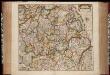
Maps of Lower Saxony

Germany - western section.
1 : 1000000 John Bartholomew and Son
NW pt. of Germany.
1 : 2150000 Bowen, Emanuel
Karte von Deutschland in IV Blättern
1 : 825000 Nordwest-Blatt Sotzmann, Daniel Friedrich im Verlage der A. G. Schneider und Weigels
The north west part of Germany.
1 : 2500000 Moll, Herman, d. 1732
The North West Part of Germany
1 : 2500000 Mollova mapová sbírka Moll, Herman Moll, Hermann
CIRCULUS WESTPHALICUS IN SUAS PROVINCIAS ET DITIONES accurate distinctus et recentissime delineat
1 : 1100000 Vestfálsko (Německo) Seutter, Matthäus cura et caelo Matth. Seutteri
Circulus Westphalicus in suas provincias et dittiones
1 : 1040000 Vestfálsko (Německo) Seutter, Matthäus cura et caelo Matth. Seutteri
Circulus Westphalicus in suas provincias et dittiones
1 : 1040000 Vestfálsko (Německo) Seutter, Matthäus cura et caelo Matth. Seutteri
Nordwest-Deutschland
1 : 2000000 Německo severozápadní Kocen, Blaž E. Hölzel
Königreich Westphalen samt dem Herzogthume Mecklenburg
1 : 2230000 Meklenbursko (Německo)
Germany.
1 : 1500000 Colton, G.W.
Circulus Westphalicus in suas provincias et ditiones accurate distinctus et recentissime delineat
1 : 1000000 cura et caelo Matth. Seutteri S.C.M.G. G. Matthaeus Seüter jun. sculpsit. Aug. Vind : [Matthäus Seutter]
Circulus Westphaliae cum omnibus suis subjacentibus provinciis novissima delineatio
1 : 1000000 1 Karte : Kupferdruck ; 49 x 56 cm Danckerts, Justus [Danckerts]
Circulus Westphalicus
1 : 1000000 Mollova mapová sbírka Seutter, Matthäus Seutter, Matthäus
Circulus Westphaliae cum Omnibus Suis Subjacentibus Provinciis Novissima Delineatio
1 : 1000000 Mollova mapová sbírka Ottens, Josua Ottens, Josua
Westphalen
Allgemeiner Atlas [Walch, Johannes] im Verlag bei Johannes Walch
Nova totius Westphaliae descriptio
1 : 804300 Vestfálsko (Německo) Visscher, Nicolaes Jansz. per Nicolaum Janßonium Vißcher
NOVA TOTIUS WESTPHALIAE DESCRIPTIO
1 : 800000 Vestfálsko (Německo) Visscher, Claes Jansz. per Nicolaum Janßonium Vißcher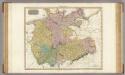
Germany north of the Mayn.
1 : 1180000 Pinkerton, John, 1758-1826

[Hannover, Braunschweig, Kurhessen, Gr. Herz. Hessen, Hess. Homburg]
Schul-Atlas in 36 Karten Völter, Daniel Verlag der J.M. Dannheimer'schen Buchhandlung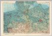
Germany - North. Pergamon World Atlas.
1 : 1250000 Polish Army Topography Service

[Vestfálsko a okolí]
Vestfálsko (Německo)
Charte des Königreichs Hannover
Neuester Schul-Atlas Walch, Johann im Verlag bei Joh. Walch
Operationen der alliirten und französischen Armee 1759


Norddeutschland
Volksschul-Atlas über alle Teile der Erde Lange, Henry Druck und Verlag von Georg Westermann
Nordwest-Deutschland.
1 : 850000 Stein, Christ. Gottfr. Dan.