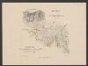
Maps of Normandy
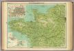
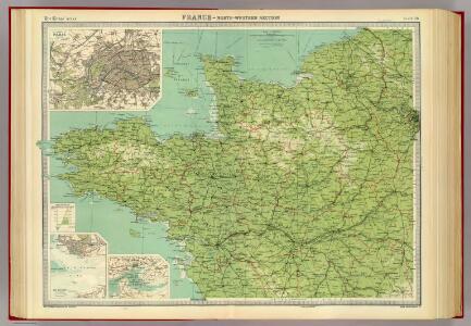
France - north-western section, environs of Paris.
1 : 1000000 John Bartholomew & Co.
Britanniae, et Normandiae Typus. 1594. Neustria. [Karte], in: Theatrum orbis terrarum, S. 67.
1 Karte aus Atlas Ortelius, Abraham
Britanniae, et Normandiae Typus. 1594. Neustria. [Karte], in: Theatrum orbis terrarum, S. 114.
1 Karte aus Atlas Ortelius, Abraham Vrients, Jan Baptista
[Frankreich, Blatt 1]
Adolf Stieler's Handatlas über alle Theile der Erde und über das Weltgebäude Stieler, Adolf Justus Perthes
[Frankreich in 4 Blättern, Blatt 1]
Handatlas über alle Theile der Erde und über das Weltgebäude Stieler, Adolf Justus Perthes
Frankreich In 4 Blattern, Blatt 1.
1 : 1500000 Vogel, C.
France 1.
1 : 1774080 Letts, Son & Co.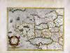
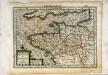
Britannia [et] Normandia cum confinib[us] regionibus
1 Karte : Kupferdruck ; 33 x 45 cm Mercator; Hondius Henricus Hondius
Britannia [et] Normandia cum confinib[us] regionibus
1 Karte : Kupferdruck ; 34 x 45 cm Hondius; Mercator Jodocus Hondius
Britannia [et] Normandia cum confinib[us] regionibus
1 Karte : Kupferdruck ; 33 x 45 cm Mercator s.n.
Frankreich NW.
1 : 1700000 Handtke, Friedrich H.
Breta[n]nia et Normandia cum confinijs
1 Karte : Kupferdruck ; 17 x 24 cm Mercator Cloppenburgh
France

8) IV. N.E. ''Cherbourg'', uit: Carte géologique de France
1 : 500000 Annotatie: Voor aanwezige bladen zie bladoverzicht [S.l : s.n.]
Der Nord-Westliche Theil von Frankreich
Hand-Atlas über alle Theile der Erde nach dem neuesten Zustande und über das Weltgebäude Stieler, Adolf bei Justus Perthes
Carte de la République française, 1
1 Blatt : 42 x 51 cm P.G. Chanlaire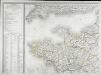
Carte de la France, 1
1 Blatt : 61 x 83 cm de Belleyme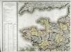
Carte de la France, 1
1 Blatt : 61 x 82 cm de Belleyme
Carte de la France (NO)
1 : 345600 Cassini family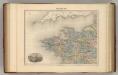
France N.O.
1 : 1615000 Migeon, J.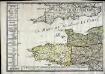
Le royaume de la France occidentale dit autrement Neustrie
1 Karte : Kupferdruck ; 39 x 49 cm, Bildgrösse 41 x 56 cm Duval chez l'auteur en l'isle du Palais sur le quay de l'Orloge
Carte de la France, 1
2 Blätter : mehrfarbig ; 72 x 81 cm de Belleyme
France Flle. N.O.
1 : 1000000 Vivien St Martin, L.
Postkarte von Frankreichs norwestlichen Departements oder der Normandie und Bretagne
Bretaň (Francie) Müller, Franz im von Reillyschen Landkarten und Kunstwerke Verschleiss Komptoir
Duche de Bretaigne [Karte], in: Novus atlas absolutissimus, Bd. 4, S. 138.
1 Karte aus Atlas Janssonius Offizin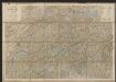
Duche de Bretaigne [Karte], in: Gerardi Mercatoris et I. Hondii Newer Atlas, oder, Grosses Weltbuch, Bd. 2, S. 74.
1 Karte aus Atlas Mercator, Gerhard und Hondius, Jodocus Jansson, Jan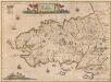
Britannia Ducatus. Duché de Bretaigne. [Karte], in: Novus Atlas, das ist, Weltbeschreibung, Bd. 2, S. 124.
1 Karte aus Atlas Blaeu, Joan Blaeu, Willem Janszoon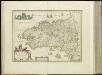
[15][15] Duche de Bretaigne, uit: Atlas sive Descriptio terrarum orbis
Annotatie: Gedigitaliseerde versie. Amsterdam. Heiloo : Picturae (vervaardiger), 2015. tiff-bestand. Gedigitaliseerd: 07-01-2015; Origineel: Universiteitsbibliotheek Vrije Universiteit (XL.05127.-) ; Netherlands; Titelpagina ontbreekt Wit, Frederik de Amsterdam : Frederick de Wit