Maps of Península Ibérica
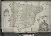
Spain, Portugal.
1 : 2050000 Faden, William, 1750?-1836
Hispania antiqua in tres præcipuas partes
1 Karte : Kupferdruck ; 46 x 64 cm Sanson; Remondini; Robert de Vaugondy; Santini apud Franc.m Santini chez Mr. Remondini
Mappa Hispaniæ antiquæ descripta
1 Karte : Kupferdruck ; 21 x 31 cm Bonne; Perrier; André s.n.
Hispania antiqua in tres præcipuas partes
1 Karte : Kupferdruck ; 46 x 56 cm Robert de Vaugondy; Sanson; Delahaye G. et D. Robert de Vaugondy
Carte de l'Espagne ancienne
1 Karte : Kupferdruck ; 39 x 49 cm Robert de Vaugondy G. Robert de Vaugondy
Hispania antiqua
1 Karte : Kupferdruck ; 40 x 52 cm Sanson; Robert de Vaugondy chés le Sr. Robert geog. ord. du roy sur le quay de l'horloge du palais
Hispania vetvs
1 Karte : Kupferdruck ; 31 x 38 cm Weigel Christoph Weigel
Hispaniae veteris descriptio
1 Karte : Kupferdruck ; 36 x 47 cm Ortelius s.n.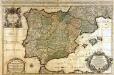
L'Espagne
1 Karte : Kupferdruck ; 53 x 85 cm Sanson; Jaillot chez H. Iaillot joignant les grands Augustins aux deux globes
Carta itineraria de España
1 : 1500000 Depósito Central de Planos de la Dirección General de Obras Públicas
España: comunicaciones terrestres
Datat al 1950 aproximadament. 0 Seix y Barral
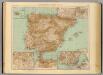
Spain and Portugal.
1 : 3380000 Sharpe, J.
Espagne Ancienne.
1 : 4850000 Malte-Brun, Conrad, 1775-1826
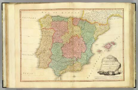
Karte von dem Iberischen Halbinsellande oder den Königreichen Spanien und Portugal
1 : 1500000 Portugalsko Berghaus, Heinrich Karl Wilhelm Brose, Heinrich J.G. Cotta's geographischer Anstalt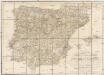
Karte von dem Iberischen Halbinsellande oder den Königreichen Spanien und Portugal
1 : 1500000 Portugalsko Berghaus, Heinrich Karl Wilhelm Brose, Heinrich J.G. Cotta's geographischer Anstalt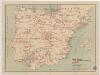
Indice gráfico de los ferrocarriles de España
1 mapa. Datat a partir de 1900 aproximadament. 0 0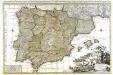
L'Espagne
1 Karte : Kupferdruck ; 56 x 87 cm Sanson; Luchtenburg chez Jean Covens et Corneille Mortier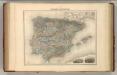
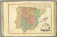
Espagne et Portugal.
1 : 3375000 Migeon, J.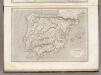
Espagne et Portugal.
1 : 3200000 Montemont, A.
[Iberische Halbinsel]
Pyrenejský poloostrov
Hispaniae Veteris Descriptio. [Karte] [Iulia Gaditana Aug. und Umgebung] [Nebenkarte], in: Novus atlas absolutissimus, Bd. 6, S. 8.
1 Karte aus Atlas Janssonius Offizin
Charte von Spanien und Portugal : mit der neuen Eintheilung
1 : 2000000 neu gezeichnet [...] von Christoph Fembo Nürnberg : Fembo
Hispaniae Veteris Descriptio.[Karte] [Iulia Gaditana Aug. und Umgebung] [Nebenkarte], in: Gerardi Mercatoris et I. Hondii Newer Atlas, oder, Grosses Weltbuch, Bd. 2, S. 207.
1 Karte aus Atlas Mercator, Gerhard und Hondius, Jodocus Jansson, Jan
37-38. Spagna, Portogallo.
1 : 3000000 Touring club italiano
Hispaniae Veteris Descriptio. [Karte] [Blastophoenices, Region Cádiz] [Nebenkarte], in: Theatrum orbis terrarum, S. 368.
1 Karte aus Atlas Ortelius, Abraham
Spanien u. Portugal.
1 : 2500000 Ziegler, J. M.
Mapa general de caminos de España y de Portugal con las nuevas divisiones de provincias sirve de continuación al Atlas nacional de España
1 : 1800000 por A.H. Dufour la geografía grabada por Desbuissons y Leclercq ; la letra grabada por Bénard Paris : Bulla
L'Espagne divisée en tous ses Royaumes Et Principautés [...] [Karte], in: Atlas nouveau, contenant toutes les parties du monde [...], Bd. 2, S. 107.
1 Karte aus Atlas Sanson, Nicolas Jaillot, Alexis Hubert und Mortier, Pieter