Maps of Germany

L'Allemagne 911 a 1024.
1 : 6300000 Houze, Antoine Philippe
L'Allemagne 1373 a 1437.
1 : 6300000 Houze, Antoine Philippe
La Germanie a la fin du 5e. siecle.
1 : 6300000 Houze, Antoine Philippe
L'Allemagne 1437 a 1612.
1 : 6300000 Houze, Antoine Philippe
L'Allemagne, l'Autriche, la Prusse et la Pologne 1612 a 1788.
1 : 6300000 Houze, Antoine Philippe
L'Allemagne 1137 a 1273.
1 : 6300000 Houze, Antoine Philippe
L'Allemagne 1024 a 1137.
1 : 6300000 Houze, Antoine Philippe
Autriche, Prusse, Confed. Germanique, Pologne 1788 a 1841.
1 : 6300000 Houze, Antoine Philippe
La Germanie 741 a 843.
1 : 6300000 Houze, Antoine Philippe
l'Allemagne par Cercles in 1789.
1 : 6300000 Malte-Brun, Conrad, 1775-1826
Europe Centrale.
1 : 4100000 Montemont, A.
Europe Centrale.
1 : 3000000 Garnier, F. A., 1803-1863
L'Allemagne 843 a 911.
1 : 6300000 Houze, Antoine Philippe
Carte Generale D'Allemagne.
1 : 4600000 Vivien de St Martin, L.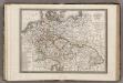
Allemagne.
1 : 5000000 Monin, C.V.
Karte des Deutschen Reichs
Schmidt, Johann Marius Friedrich; Jäck Schropp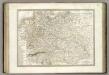
Allemagne.
1 : 3300000 Lapie, M. (Pierre), 1779-1850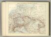
Carte Politique de L'Europe Centrale.
1 : 3600000 Jouvet et Cie.
Germany.
1 : 6000000 Finley, Anthony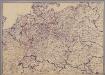
[Mitteleuropa]
1 : 2500000 [S.l. : s.n.]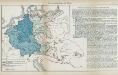
Nr. 8a. Die Germanisierung des Ostens
Ostmitteleuropa Deutsche, Siedlung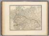
L'Allemagne, l'Europe centrale.
1 : 3460000 Andriveau-Goujon, J.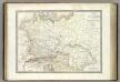
Germanie Ancienne.
1 : 3300000 Lapie, M. (Pierre), 1779-1850
Deutschland mit der Kreis-Eintheilung von 1512
Evropa střední Benecke Bormann, E. F. Tempsky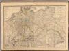
Composite: Allemagne.
1 : 2000000 Andriveau-Goujon, J.
Neueste Post Karte von ganz Deutschland
1 : 1460000 Evropa střední Müller, Franz Artaria
Der Deutsche Bund samt der Helvetischen Eidgenossenschaft aft. 1828
Historisch-genealogisch-geographischer Atlas von Le Sage Las Cases, Emmanuel Auguste Dieudonné Marius Joseph de Johann Velten, Kunsthändler
Neueste und vollstaendigste Post Karte von ganz Deutschland Niederlanden Schweiz Pohlen Ungarn und den angränzenden Theilen Frankreichs u Italien
Evropa střední Cappi, Jean Jean Cappi