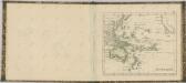
Maps of Seven Seas (Open Ocean)

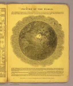
Picture of the World.
1 : 89000000 Huntington, Hezekiah, 1795-1865
Die sichtbare Seite der Mond-Oberflache bei voller Beleuchtung.
1 : 13000000 Stieler, Adolf

Afrique spheroidale.
1 : 41000000 Garnier, F. A., 1803-1863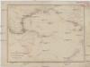
Der Vulkan-Gürtel und die Central-Gruppen des Grossen Oceans
Tichý oceán Buch, Leopold von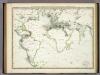
Die Vulkanischen Erscheinungen Der Atlen Welt.
1 : 65000000 Berghaus, Heinrich
Vorstellvng der in der Nacht zwischen den 8. u. 9. Aug; 1748
Mollova mapová sbírka Mayer, Tobias Homann, Johann Baptista - dědici
Die verfinsterte Erdkugel :
Mollova mapová sbírka Lowitz, Georg Moriz Schneider, Ruprecht Adam Homann, Johann Baptista - dědici
Atlantic Ocean.
1 : 95000000 Huntington, Hezekiah, 1795-1865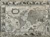
Nova Totius Terrarum Orbis Geographica Ac Hydrographica Tabula
Blaeu, Willem Janszoon; Ende, Josua van den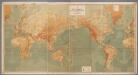
Weltkarte zur Übersicht der Meerestiefen & Höhenschichten, mit Angabe der unterseeischen Telegraphen-Kabel und Überland-Telegraphen, sowie der Kohlenstationen & Docks / bearb. u. gez. v. K. Blume ; gestochen im Atelier v. H. Petters
1 : 28000000 Blume, K.; Petters, H. Berlin : Hydrographisches Amt des Reichs-Marine-Amts [etc.]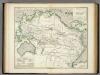
Karte vom Grossen Ocean, (Mare Pacifico).
1 : 90000000 Berghaus, Heinrich
Pacific Ocean.
1 : 86000000 Smiley, Thomas T.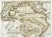
Carte physique de la Grande Mer ci-devant nommée mer du Sud ou Pacifique
1 Karte : Kupferdruck ; 29 x 41 cm, Blattgrösse 47 x 61 cm Buache; Desbruslins Philippe Buache
Nova Totius Terrarum Orbis Gepgraphica Ac Hydrographica Tabula. [Karte], in: Gerardi Mercatoris et I. Hondii Newer Atlas, oder, Grosses Weltbuch, Bd. 1, S. 25.
1 Karte aus Atlas Mercator, Gerhard und Hondius, Jodocus Jansson, Jan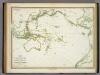
Karte von dem Vulkan Gurtel.
1 : 65000000 Berghaus, Heinrich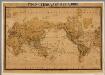
Productenkaart der Aarde / neu bearb. Osw. Meinke
1 : 54600000 Meinke, Osw. Esslingen : Harburger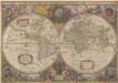
Nova Totius Terrarum Orbis Geographica Ac Hydrographica Tabula. [Karte], in: Novus atlas absolutissimus, Bd. 1, S. 14.
1 Karte aus Atlas Janssonius Offizin
Carte physique de l'ocean où l'on voit des grandes chaînes de montagnes qui traversent les continents d'Europe, d'Afrique et d'Amérique
1 Karte : Kupferdruck ; 27 x 34 cm, Blattgrösse 47 x 62 cm Buache; Desbruslins Philippe Buache
Orbis Terrarum Veteribus Cogniti Typus Geographicus. [Karte], in: Novus atlas absolutissimus, Bd. 10, S. 8.
1 Karte aus Atlas Janssonius Offizin
Pacific Ocean.
1 : 95000000 Huntington, Francis Junius, 1802-1878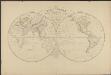
Mappemonde en deux hémisphères où sont tracées les lignes de faîte des grands bassins qui partagent la surface du globe
1 : 44000000 par L. Vivien gravé par Desbuisson [...] ; écrit par Arnoul Paris : Hachette
Mappe-Monde = Geo-Hydrographique, ou Descritption Generale Du Globe Terrestre Et Aquatique En Deux-Plans-Hemispheres. [Karte], in: Atlas nouveau, contenant toutes les parties du monde [...], Bd. 1, S. 32.
1 Karte aus Atlas Sanson, Nicolas Jaillot, Alexis Hubert und Mortier, Pieter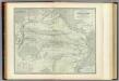
Pacific Ocean.
1 : 45000000 Johnston, Alexander Keith, 1804-1871
Atlas über die Entwicklung von Industrie und Handel der Schweiz in dem Zeitraume vom Jahr 1770 bis zum Jahr 1870
1 : 45000000 1 Atlas ([3], VIII Bl.) im Auftrage der schweizerischen Commission für die additionellen Ausstellungen in Wien, bearbeitet von Dr. Hermann Wartmann Wurster Randegger & Co., Winterthur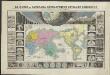
Le monde ou panorama géographique du globe terrestre, représentant les terres et les mers du globe, ses accidents physiques, les phénomènes, les règnes de la nature [...]
1 : 177600000 réd. d'après Mr. De Humbold et les savans les plus distingués par E. Hocquart [S.l.] : [s.n.]
Elementaratlas der allgemeinen Geographie in sechs Blättern No 6.

A chart of the discoveries made by the late Capt. Cook, & other European navigators, in the great Pacific Ocean between Asia and America
Kitchin, Thomas Baldwin, Richard