Maps of Bavaria
Bavaria.
1 : 835000 Cary, John, ca. 1754-1835
Das Herzogthum Ober und Nieder Bayern
1 Karte : Kupferdruck ; 22 x 27 cm Reilly F. J. J. von Reilly
Boioaria aetate romanorvm collata cvm hodierna
1 Karte : Kupferdruck ; 24 x 29 cm Braun; Zimmermann Ruprecht
Cercle de Baviere
1 : 1100000 Bavorsko (Německo) Mentelle, Edme Tardieu, Pierre François
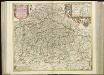
Circulus Bavaricus, in qua Archiep. Saltzburgi, Episc. Ratisbonae, Passaviae et Freisingiae. Praep. Bergtolsgadiae. Ducat. Superior. et Inferior. Bavariae, et Neoburgi; Comitat. Palatinus. et Landgrav. Luchtenbergae.
1 : 675000 Mollova mapová sbírka Valk, Gerhard Valck, Gerard
Circulus Bavaricus
1 Karte : Kupferdruck ; 56 x 48 cm Valck; Valck Valck
Suevia Et Bavaria XII. Nova Tabula. [Karte], in: Claud. Ptolemaeus. Geographia lat. cum mappis [...], S. 383.
1 Karte aus Atlas Münster, Sebastian [und Ptolemaeus, Claudius]
[Atlas zur Geschichte von Bayern] : IV. Die Herzogthümer Baiern, Franken, und ein Theil von Alemannien im XII & XIII Jahrhundert nach erblichen Grafschaften & Gebieten getheilt
K. v. Spruner [Gotha : Perthes]
Teutschlandes Bayerischer Creiss samt dazu gehörigen Provintzen
1 : 2500000 Mollova mapová sbírka Weigel, Johann Christoph Weigel, Christoph I.
Bavaria.
1 : 1650000 Bowen, Frances
CHARTE vom KÖNIGREICHE BAYERN
Bavorsko (Německo)
[Atlas zur Geschichte von Bayern] : II. Die Gauen von Bojoaria, Franconia, und eines Theils von Alemannia vom VIIIten bis in’s XIte Jahrhundert
K. v. Spruner [Gotha : Perthes]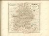

Karte vom Königreich Baiern
1 : 1100000 Bavorsko (Německo) in A.G. Schneider u. Weigels k. priv. Kunst- u. Landkartenhandlung
Le cercle de Baviere, subdivisé en touts les estats qui le composent
1 : 600000 Bavorsko (Německo) Sanson, Guillaume Jaillot, Alexis-Hubert H. Iaillot
[Atlas zur Geschichte von Bayern] : VII. Das Königreich Bayern nach seinen gegenwärtigen Bestandtheilen mit allen Gebiets-Veränderungen von 1801 bis 1816
K. v. Spruner W. Hase sc. Weimar [Gotha : Perthes]
Salisbvrgensis Ivrisdictionis, locorumque vicinorum vera descriptio
1 : 730000 Mollova mapová sbírka Setznagel, Marx Rade, Gillis van den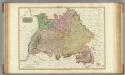
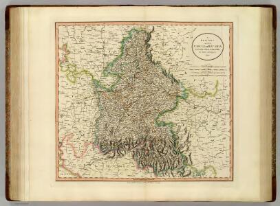
Germany south of the Mayn.
1 : 885000 Pinkerton, John, 1758-1826
Charte des Bayrischen Kreises
1 Karte : Kupferdruck ; 55 x 44 cm Schmidburg; Zach; Amman; Cassini de Thury; David; Humboldt im Verlage des privil. Landes-Industrie-Compt
Charte vom Königreiche Bayern
1 : 1040000 Bavorsko (Německo) Güssefeld, Franz L. Ehnlich, I. F. C. im Verlag des Geograph. Instituts
Königreich Bayern
1 : 1284000 Bavorsko (Německo) Tranquillo Mollo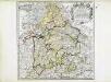
Bayern
1 Karte : Kupferdruck ; 41 x 41 cm Sanson; Cordier chez l'autheur
Charte vom Königreiche Bayern
Bavorsko (Německo) Streit, Friedrich Wilhelm
CHARTE vom KÖNIGREICHE BAYERN
Bavorsko (Německo)
Charte vom Königreiche Bayern
Bavorsko (Německo)
Chur-Bayern im Jahr 1804
1 : 1083000 Bavorsko (Německo) Herdegen, J. C. F. Leizel, Balthasar Friedrich J.L.C. Rheinwald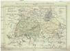
Postkarte von dem Bayrischen und Schwaebischen Kreise
Bavorsko (Německo) Müller, Franz Deilly'schen Lankarten und Kunstwerke Verschleiss Komtoir
Postkarte von dem Bayrischen und Schwaebischen Kreise
Bavorsko (Německo) Müller, Franz im von Reilly'schen Landkarten und Kunstwerke Verschleiss Komptoir
Geographische Mauth=Charte von Baÿern
1 Karte : Kupferdruck ; 55 x 65 cm Kohlbrenner; Lotter s.n.