Maps of Outer Hebrides
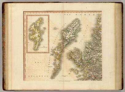
Scotland NW.
1 : 500000 Cary, John, ca. 1754-1835
Pascaarte, verthoonende in wat ghestalte de Eylanden (Hebrides ghenaemt) achter de noordwesthoek van Schotlandt gheleghen zÿn = Carte marine de les Isles Hebrides situez vers norouest arriere l'Escoss
Blaeu, Willem Janszoon, 1571-1638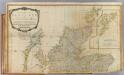
Scotland (north)
1 : 450000 Robert Laurie & James Whittle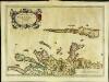
Æbudæ insulæ sive Hebrides
1 Karte : Kupferdruck ; 37 x 52 cm Blaeu; Pont Joan Blaeu
Tabula Leogi et Haraiae, ac Skiae vel Skianae Insularum. [Karte], in: Novus atlas absolutissimus, Bd. 8, S. 169.
1 Karte aus Atlas Janssonius Offizin
A new chart of the West coast of Scotland from the Mull of Galloway to Dunan Point in Sky.
Huddart, Joseph, 1740/1-1816 Laurie, Robert Whittle, James
Carte particuliere de la cote occidentale d'Escosse, depuis le Cape Wrath jusqu'a la Pointe d'Ardnamurchan.
Depot Generale de la Marine, Paris
A new chart of the West coast of Scotland from the point of Ardnamurchan to Cape Wrath.
Huddart, Joseph, 1740/1-1816 Laurie, Robert Whittle, James
A Map of the North West part of the Western Islands / by H. Moll.
Moll, Herman, d. 1732
A general map of Scotland and islands thereto belonging, 1
2 Blätter : 90 x 76 cm s.n.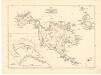
Map of St Kilda or Hirta and adjacent islands...
Mathieson, John
St Kilda.
Stevenson, Robert, 1772-1850
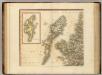
Western Isles.
Thomson, John, 1777- ca. 1840 Johnson, William, fl. 1806-1840
Western Isles.
Thomson, John, 1777- ca. 1840 Johnson, William, fl. 1806-1840
Western Isles.
Thomson, John, 1777- ca. 1840 Johnson, William, fl. 1806-1840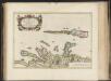
Aebudae Insulae sive Hebrides ; quae Scotiae ad occasum praetenduntur / lustratae et descriptae a Timotheo Pont. Western Isles of Scotland.
Pont, Timothy, 1560?-1614? Blaeu, Joan, 1596-1673
Scotland[Motoring Map of]
London : "Geographia
Pascaert vande westkust van Schotlant, als mede een gedeelte van de Lewys Eylanden, van S. Patricius tot Nary, Nog t'I. Roda ofte Barre en t'I. S. Kilda met al Syn diepten en droochten, dus ver naeuke
Keulen, Johannes van, 1654-1715
Tabula Leogi et Haraiæ, ac Skiæ vel Skianæ insularum
1 Karte : Kupferdruck ; 43 x 51 cm Valck; Schenk ex officina Gerardi Valk et Petri Schenk
Scotland / J. Ainslie, 1
1 Blatt : 64 x 58 cm Ainslie, Faden
Hebrides or Western Isles from Barra Head to Scarpa Id.
Great Britain. Hydrographic Office
Ardnamurchan to Summer Isles, including the Inner Channel and part of the Minch.
Great Britain. Hydrographic Office
The Shires of Ross, and Cromartie / by Her. Moll.
Moll, Herman, d. 1732
LEOGVS et HARAIA, | insulæ ex Æbudarum numero, | quæ, quamquam isthmo cohæreant, | pro diversis habentur. | LEWIS and HARRAY | of the numbre of the Westerne Yles, which two although | they ioyne be a necke of land ar accounted dyvers Ylands.
[Amsterdam : Joan Blaeu]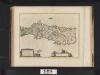
Leogus et Haraia insulae ex Aebudarum numero, quae quamquam isthmo cohaereant, pro diversis habentur. Lewis and Harray of the numbre of the Western Yles, which two although they ioyne be a necke of la
Blaeu, Joan, 1596-1673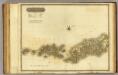
Western Isles S.
1 : 106000 Thomson, John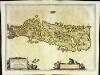
Leogvs et Haraia
1 Karte : Kupferdruck ; 38 x 51 cm Blaeu Joan Blaeu
The North Minch
Great Britain. Hydrographic Office
VISTVS INSVLA, | vulgo VIIST, | cum aliis minoribus | EX ÆBVDARVM NVMERO | ei ad meridiem adjacentibus.
Auct. Timotheo Pont. [Amsterdam : Joan Blaeu]