Maps of Carpathian Mountains
Poland, Prussia, and Hungary.
1 : 5000000 Lavoisne, M.
Tabula nova totius regni Poloniae
1 : 4050000 Litva Sanson, Nicolas Visscher, Nicolaus apud Nicolaum Vißcher
REGNUM POLONIAE ejusque confinia
1 : 10700000 Evropa východní
Westliches Russland
1 : 2000000 Evropa východní Handtke, Friedrich Carl Flemming
Regni Poloniae, Magni Ducatus Lithuaniae Coeterarumq[ue] Regi Poloniae Subditarum Regionum Tabula
1 : 3100000 Allard, Carel
Regni Poloniae magnique ducatusq. Lithuaniae nova et exacta tabula
1 : 3130000 Bělorusko Homann, Johann Baptist Starowolski, Szymon Homannovi dědicové
REGNI POLONIAE MAGNIQUE DUCATUS LITHUANIAE Nova et exacta tabula
1 : 3200000 Bělorusko Homann, Johann Baptist Starowolski, Szymon Homannovi dědicové
Regni Poloniae magnique ducatusq. Lithuaniae nova et exacta tabula
1 : 3130000 Bělorusko Homann, Johann Baptist Starowolski, Szymon Homann Erben
Regni Poloniae magnique ducat[us] Lithuaniae nova et exacta tabula
1 : 3041000 Bělorusko Homann, Johann Baptist Starowolski, Szymon â Iohanne Bapt. Homanno
Tabula noua Poloniæ, Vngariæ, & Russiæ
1 : 3700000 1 Karte : Holzschnitt ; 28 x 36.5 cm Ptolemaeus, Claudius Apud Hugonem à Porta
Herzogthum Warschau 1810
1 : 20000000 Herzogtum Warschau
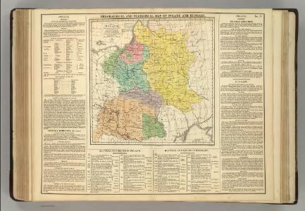
Poland: Language. No.2
1 : 3000000 Series of maps on various aspects of Poland. Distribution of languages according to various authorities. War Office
Mappa geographica ex novissimis observationibus repraesentans Regnum Poloniae et Magnum Ducatum Lithuaniae
1 : 2000000 cura et sumptibus Tobiae Conradi Lotter Aug[usta] Vind[elicorum] : sumptibus Tobiae Conradi Lotter
Herzogthum Warschau 1808
1 : 20000000 Herzogtum Warschau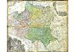
Mappa Geographica Regni Poloniae
Mayer, Tobias
Poland: Density
1 : 3000000 Series of maps on various aspects of Poland. Density. Number of inhabitants per square kilometre. War Office
Poland: Poles (excluding Jews)
1 : 3000000 Series of maps on various aspects of Poland. Poles (excluding Jews). Kingdom of Poland (1897) an Galicia (1900). Distribution of Poles, showing minorities. War Office
Mappa geographica Poloniae, in partes suas majores Austriac. Russic. et Borrusic
1 : 2920000 Polsko per Hommanianos Heredes
Estats de la couronne de Pologne
1 : 2800000 Evropa východní Jaillot, Alexis-Hubert H. Jaillot
ESTATS DE LA COURONNE DE POLOGNE
1 : 2800000 Evropa východní Jaillot, Alexis-Hubert H. Jaillot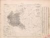
Poland: Poles
1 : 3000000 Series of maps on various aspects of Poland. Distribution of Poles showing minorities. War Office
Mapa Polski
1 : 1500000 Evropa střední a východní Pokorny, Wilhelm Tomaszewski, Adam Księgarnia polska Bernarda Połonieckiego
Mappa geographica ex novissimis observationibus repraesentans regnum Poloniae et magnum ducatum Lithuaniae
1 : 2740000 Litva Probst, Johann Michael Ioh. Michael Probst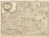
Estats de la couronne de Pologne
1 : 2600000 Evropa východní Sanson, Guillaume Cordier, Louis chez H. Jaillot
Dritte Theilung Polens 1795
Polen Teilung Polens <1795>

General-Karte vom westlichen Russland nebst Preussen, Possen und Galizien
1 : 2000000 Halič (Polsko a Ukrajina) Handtke, Friedrich C. Flemming
Poland: Language. No.1
1 : 3000000 Series of maps on various aspects of Poland. Languages in 1910-1913. War Office
Polska za Mieczyslawa I
Polsko