Maps of Ireland
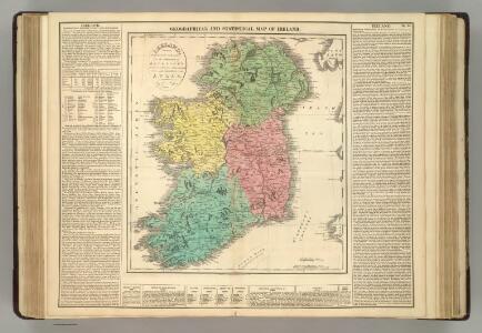
Ireland.
1 : 1360000 Lavoisne, M.
Regnum Hiberniae
1 : 888000 Irsko Lotter, Tobias Conrad sumptibus Tobiae Conradi Lotteri
Ireland.
1 : 1900000 Darton, William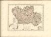


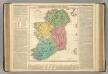
Ireland.
1 : 1010000 Playfair, Principal
HIBERNIAE REGNUM
1 : 950000 Irsko Homann, Johann Baptist Petty, William a Ioh. Bapt. Homanno
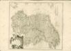
Hiberniae regnum
1 : 920000 Irsko Homann, Johann Baptist Petty-Vischeriano, Guillaume J. B. Homann

Hiberniae regnum tam in praecipuas Ultoniae, Connaciae, Lageniae, et Momoniae, quam in minores earundem provincias et ditiones subjacentes peraccuraté divisum ae noviter delineatum
1 : 900000 per Guilielmus Petty et in lucem editum per Nicolaum Visscher Amst. Bat. [Amsterdam] : nunc apud Pet. Schenk Iunior
Regnum Hiberniae, tam secundum IV provincias principales Ultoniam, Connaciam, Lageniam, Momoniam quam speciales, accuratae designata
1 : 910000 Connacht (Irsko) Lotter, Tobias Conrad sumptibus Tobiae Conradi Lotteri
Royaume d'Irlande
1 : 1950000 Irsko Bonne, Rigobert André
Das Konigreich Ireland
1 Karte : Kupferdruck ; 26 x 20 cm Reilly F. J. J. von Reilly
Karte von Ireland
1 Karte : Kupferdruck ; 62 x 55 cm Kitchin; Schrämbl; Stenger zu finden in eigenem Verlage Schrämbl
Le royaume d'Irlande
1 Karte : Kupferdruck ; 56 x 47 cm Le Rouge; Basset chez Basset rue St. Jacques
Le royaume d'Irlande
1 Karte : Kupferdruck ; 56 x 47 cm Le Rouge; Basset; Basset chez Basset rue St. Jacques
Regnum Hiberniæ
1 Karte : Kupferdruck ; 56 x 48 cm Lotter Tobias Konrad Lotter
L'Irlande
1 Karte : Kupferdruck ; 85 x 52 cm s.n.
A new and accurate map of Ireland
1 Karte : Kupferdruck ; 31 x 21 cm Bowen s.n.
Le royaume d'Irlande
1 Karte : Kupferdruck ; 56 x 47 cm Le Rouge par et chez le Sr. Le Rouge ing.r géographe du roy ruë des Augustins
Regnum Hiberniæ
1 Karte : Kupferdruck ; 56 x 48 cm Seutter Matthäus Seutter
Hyberniæ regni in provincias Ultoniam, Connachiam, Lageniam, Momoniamq divisi tabula accuratissima
1 Karte : Kupferdruck ; 57 x 49 cm by I. Cóvens en C. Mortier op de Vygendam
Regni Hiberniæ accurata tabula
1 Karte : Kupferdruck ; 38 x 32 cm Weigel; Moll; Kauffer Christoph Weigel
Hiberniæ regnum
1 Karte : Kupferdruck ; 55 x 47 cm Homann; Petty; Visscher Johann Baptist Homann
Hiberniæ regnum
1 Karte : Kupferdruck ; 55 x 46 cm Visscher Nicolaes Visscher
[88][88] Regnum Hiberniae ..., uit: Atlas sive Descriptio terrarum orbis
Annotatie: Gedigitaliseerde versie. Amsterdam. Heiloo : Picturae (vervaardiger), 2015. tiff-bestand. Gedigitaliseerd: 07-01-2015; Origineel: Universiteitsbibliotheek Vrije Universiteit (XL.05127.-) ; Netherlands; Titelpagina ontbreekt Wit, Frederik de Amsterdam : Frederick de Wit
Nouvelle carte de l'Irlande
1 : 1500000 Irsko Chatelain, Henri-Abraham Chatelain
A pocket companion of Ireland.
1 : 1700000 Moll, Herman, d. 1732