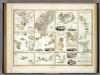
Maps of Sahara
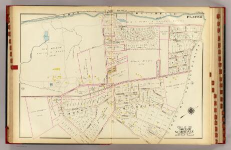
Scarsdale.
1 : 3600 Bromley, George Washington; Bromley, Walter Scott; G.W. Bromley & Co.
Hillsborough Bridge P.O.
D.H. Hurd & Co.
Lisbon, Littleton.
1 : 4800 D.H. Hurd & Co.
Province of Nova Scotia (Island of Cape Breton). Sheet no. 20.
1 : 63360 Geological Survey of Canada
Goffstown, Hillsborough Co.
1 : 26000 D.H. Hurd & Co.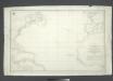
Carta general del Oceano Atlantico ú ocidental desde 52o de latitud norte hasta el Equador / construida de orden del Rey en el Deposito Hidrografico de Marina y presentada á S.M. por mano del Exmo. Señor D. Antonio Cornel, Secretario de Estado y del Despacho Universal de Guerra, Encargado del de Marina y de la Direccion General de la Real Armada.
from Atlantic Ocean D. Antonio Cornel,
Noroeste de Africa
1 mapa. Datat al s. XIX. Gras y compañia, editores. Madrid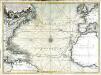
Nouvelle carte de l'ocean Atlantique et théatre de la guerre tant en Europe qu'en Amerique
1 Karte : Kupferdruck ; 52 x 71 cm Denis; Basset; Basset chés Basset rüe St. Jacques au coin de celle des Mathurins à l'image S.te Genevieve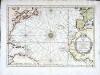
Carte de l'ocean occidental
1 Karte : Kupferdruck ; 31 x 44 cm Bellin Arkstée et Merkus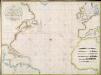
A new chart of the Atlantic or Western Ocean / improved by W. Heather; engraved by J. Stephenson.
from Charts and maps W. Heather; J. Stephenson,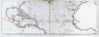
Océan atlantique et mers adjacentes, 2
2 Blätter : 47 x 135 cm Le Rouge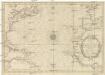
CARTE DE L'OCEAN OCCIDENTAL
1 : 6600000 Atlantský oceán-oblast Bellin, Jacques-Nicolas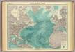
North Atlantic Ocean.
1 : 25000000 John Bartholomew & Co.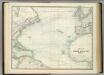
North Atlantic Ocean.
1 : 17500000 Johnston, Alexander Keith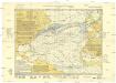
Monatskarte für den Nordatlantischen Ozean
1 : 10700000 Atlantský oceán (oblast) Eckardt & Messtorff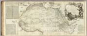
Africa, with all its states, kingdoms, republics, regions, islands, &ca. (northern section)
1 : 8400000 Boulton, S.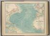
North Atlantic Ocean.
1 : 19000000 Johnston, W. & A.K.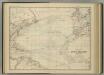
North Atlantic Ocean.
1 : 17500000 Johnston, Alexander Keith
Tableau des courants observés dans l'Océan Atlantique Septentrional, au moyen de bouteilles jetées à la mer. / dressé par P. Daussy, ingénieur hydrographe en chef de la Marine; gravé par Michel; écrit par J.M. Hacq.
from Atlantic Ocean P. Daussy; Michel; J.M. Hacq.,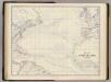
N. Atlantic Ocean.
1 : 19000000 Johnston, Alexander Keith, 1804-1871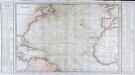
Carte générale de l'océan Atlantique ou Occidental
1 Karte : Kupferdruck ; 59 x 88 cm s.n.
Chart of the Atlantic Ocean.
1 : 43000000 Melish, John
Mittel- und Nord-Africa und Arabien. Westliches Blatt
Stieler's Hand-Atlas Stieler, Adolf bei Justus Perthes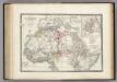
Afrique partie Nord.
1 : 16000000 Levasseur, E.
Tabula Moderna Prime Partis Aphricae [Karte], in: Claudii Ptolemei viri Alexandrini mathematice discipline philosophi doctissimi geographie opus [...], S. 263.
1 Karte aus Atlas Waldseemüller, Martin [und Ptolemaeus, Claudius] Übelin, Georg
Mittel- und Nord-Africa, westl. Theil

Chart of the Atlantic Ocean: with an illustration of the character and rout[e] of a storm which occurred on the American coast in August 1830 / William Hooker, engraver, New York.
from Atlantic Ocean William Hooker,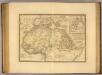
Afrique, septentrionale.
1 : 16000000 Picquet, C.
A new chart of the vast Atlantic Ocean: exhibiting the seat of war, both in Europe and America, likewise the trade winds & course of sailing from one continent to the other, with the banks, shoals and rocks drawn according to the latest discoveries, and regulated by astronomical observations / Emanl. Bowen, sculp.
from Atlantic Ocean Emannuel Bowen,