Maps of Elburz Mountains
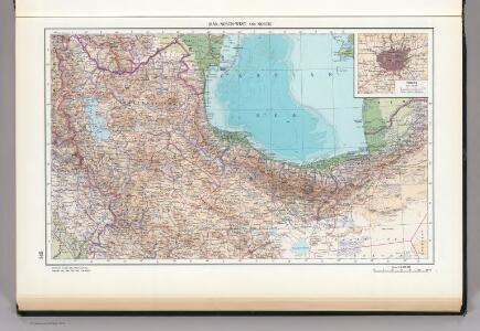
145. Iran, North-west and North. Tehran. The World Atlas.
1 : 2500000 USSR (Union of Soviet Socialist Republics).
[Westküste des Kaspischen Meeres]
Kaspické moře (oblast)
[Carte marine de la mer Caspiene / levée suivant les ordres de S. M. czariene, par Mr. Carl Vanverd
1 : 1600000 1 Kartenblatt : Kupferdruck ; 43 x 59 cm Verden, Carl van [par Reinier Ottens]
Prof. C. Haussknecht's Routen im Orient 1865-1869 : III. Kurdistan und Irak
1 : 800000 Kiepert, Heinrich, 1818-1899 Verlag von Dietrich Reimer
Western Persia.
1 : 3380000 Sharpe, J.
Nova ac verissima Maris Caspii ante hac maximam fere partem nobis incognita ac regionum adjacentium delineatio : jussu invictissimi principis Petri Alexii fil. magni Russorum imperatoris
1 : 1500000 immenso labore et maximis sumptibus facta, atque ex autographo in lucem edita per Reinerum Ottens geographum Amstelaedam. Iacob Keyser sculp. Gedrukt t'Amsterdam : by de Wed. I. Ottens op de Nieuwen Dyk in de Wereldkaart
West-Persien, oder die westlichen Stufenländer des Iranischen Hochlandes
1 : 3000000 Šíráz (Írán) Kiepert, Heinrich D. Reimer
Feuille 35 (G V), uit: Carte géologique internationale de l'Europe : la carte, votée au congrès géologique international de Bologne en 1881, est exécutée conformément aux décisions d'une commission internationale, avec le concours des gouvernements, sous le dir. de M.M. Beyrich et Hauchecorne
Annotatie: Blad 48 gamme des couleurs; blad 49: bladwijzer en titelblad Heinrich Ernst Beyrich 1815-1896; Wi. Hauchecorne Berlin : Reimer / (Berlin: Institut lithographique)
Kaerte van de waerschijnlijkste plaets van den Hof van Eden, de vlakte van Sinear, en den berg, waer op d'Ark gerust heeft, volgens deeze histori
Annotatie: Afkomstig uit dl. I van: Algemeene histori van het begin der wereld af tot den tegenwoordigen tijd toe / ... door Kornelis Westerbaen Wz. - Utrecht : Hermanus Besseling, 1735-1755; Rechtsboven: I Deel tusschen bl. 460 en 461 [Utrecht : H. Besseling excudit]
[XX], uit: Geognostische Karte des Oesterreichischen Kaiserstaates mit einem grossen Theile Deutschland's u. Italien / hauptsachlich nach ... Haidinger's geognostischer Karte dieses Staates bearb. von Josef Scheda
1 : 3000000 titelvariant: General-Karte von Europa in 25 Blättern; Annotatie: Bijlage bij: General-Karte von Europa in 25 Blättern. - 1:2.592.000. - 1845-1847 Scheda, Joseph Wien : K.K. Militär. Geografisch. Institut
Karte von dem Caspischen Meer
1 : 3100000 Kaspické moře-oblast Wussin, I. Güldenstädt, Johann Anton F.A. Schraembl
Friedensdislokation im europäischen Russland
1 : 3125000 Kavkaz-oblast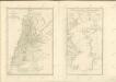

[Tertia Asie tabula] [Karte], in: Clavdii Ptholomei Viri Alexandrini Cosmographie, S. 170.
1 Karte aus Atlas Nicolaus Germanus [und Ptolemaeus, Claudius]
Provinciarum persicarum Kilaniae nempe Chirvaniae Dagestaniae aliarumque vicinarum regionum partium
1 : 2000000 1 Karte : Kupferdruck ; 47 x 56 cm Homann, Johann Christoph [Homann]
Karta Kaspijskago morja
1 Karte : Kupferdruck ; 24 x 14 cm Güldenstädt; Maksimov s.n.
Carte des Caspischen Meeres
1 Karte : Kupferdruck ; 24 x 14 cm Güldenstädt s.n.
Essai d'une nouvelle carte de la mer Caspienne
1 Karte : Kupferdruck ; 51 x 25 cm Anville; Delahaye s.n.
A new and accurate map of the Caspian sea
1 Karte : Kupferdruck ; 31 x 21 cm Bowen s.n.
Carte marine de la mer Caspiene
1 Karte auf 2 Blatt : Kupferdruck ; 86 x 60 cm Verden; L'Isle chez le Sr. Delisle quay de l'horloge
Geographica nova ex oriente gratiosissima, duabus tabulis specialissimis contenta quarum una mare Caspivm altera Kamtzadaliam seu terram Jedso curiosè exhibe[n]t
2 Karten auf 1 Blatt : Kupferdruck ; Bildgrösse 48 x 56 cm Homann editore Io. Bapt. Homann S. C. M. geogr
A new and accurate map of the Caspian sea / by Eman.l Bowen
1 : 4400000 1 Karte : Kupferdruck ; Bowen, Emanuel [Printed for William Innys and Joseph Richardson ... [et al.]]
Geographica nova ex oriente gratiossima, duabus tabulis specialissimis contenta, quarum una mare Caspivm, alt[e]ra Kamtzadaliam se[u] terram Jedso curiosé [e]xhibe[n]t
Kamčatka (Rusko) Homann, Johann Baptist Io. Bapt. Homann
No.30. Karta Evropeyskaia Rossiia. Sheet 16
1 : 2000000 Shokalskago,Iu. M.
Caspian Sea.
1 : 4530000 Orbeliani, Sulxan-Saba, 1658-1725
Karte von dem Caspischen Meer
1 Karte : Kupferdruck ; 48 x 26 cm Schrämbl; Güldenstädt; Wussin zu finden in eigenem Verlage Schrämbl
Carte de la mer Caspienne
1 Karte : Kupferdruck ; 60 x 45 cm Clerc; Tardieu; Aubert s.n.
Drit[t]e Revolution des Caspischen Meeres, oder Karte, des Abulfeda
1 Karte : Kupferdruck ; 20 x 29 cm Abū ăl-Fidāʾ Philipp Heinrich Perrenon
Zwote Revolution des Caspishen Meeres, oder Karte, des Ptolemæus
1 Karte : Kupferdruck ; 20 x 29 cm Ptolemaeus Philipp Heinrich Perrenon