Maps of Kamchatka Peninsula

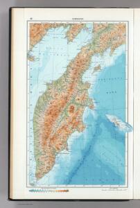
42. Kamchatka. The World Atlas.
1 : 3000000 USSR (Union of Soviet Socialist Republics).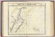
Partie, Russie d'Asie. Asie 28.
1 : 1641836 Vandermaelen, Philippe, 1795-1869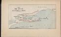
Plan of the attack on Petropavlofsk
Russland Sibirien Kamtschatka Petropawlowsk-Kamtschatski Krimkrieg Philip, George ; Philip, [Sohn v. G.]
Kamschatka
1 : 4000000 Kamčatka (Rusko)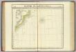
Partie du Kamtchatka. Asie 37.
1 : 1641836 Vandermaelen, Philippe, 1795-1869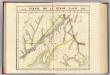
Partie, Russie d'Asie. Asie 18.
1 : 1641836 Vandermaelen, Philippe, 1795-1869
Ice Chart, Okhotsk Sea Region, October.
U.S. Navy
Ice Chart, Okhotsk Sea Region, February.
U.S. Navy
Ice Chart, Okhotsk Sea Region, December.
U.S. Navy
Ice Chart, Okhotsk Sea Region, May.
U.S. Navy
Ice Chart, Okhotsk Sea Region, July.
U.S. Navy
Ice Chart, Okhotsk Sea Region, March.
U.S. Navy
Ice Chart, Okhotsk Sea Region, April
U.S. Navy
Ice Chart, Okhotsk Sea Region, January.
U.S. Navy
Suite de la carte de la Sibérie et le pays de Kamtschatka
1 : 14500000 1 Karte : Kupferdruck ; 23 x 25 cm [Bellin]
Suite de la carte de la Sibérie et le pays de Kamtschatka
1 : 14500000 1 Karte : Kupferdruck ; 23 x 25 cm [Bellin]
Ice Chart, Okhotsk Sea Region, November.
U.S. Navy
Ice Chart, Okhotsk Sea Region, June.
U.S. Navy
Ice Chart, Okhotsk Sea Region, August.
U.S. Navy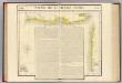
Partie, Russie d'Asie. Asie 27.
1 : 1641836 Vandermaelen, Philippe, 1795-1869
Iles Kuriles, Aleutiennes.
1 : 1900000 La Perouse, Jean-Francois de Galaup, comte de, 1741-1788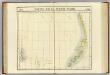
Partie de la Russie d'Asie. Asie 36.
1 : 1641836 Vandermaelen, Philippe, 1795-1869
[Východní Asie].
Asie východní Berghaus, Heinrich Karl Wilhelm Horsburgh, James
Russia asiatica
1 : 13000000 1 Karte : Kupferdruck ; 42 x 30 cm presso Antonio Zatta, e figli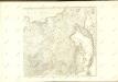

General'naja karta azijatskoj časti Rossijskoj imperii
1 : 26000000 Rusko východní Korsakov, P.
CHARTE vom ASIATISCHEN RUSSLAND
Rusko východní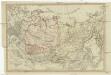
Charte vom Asiatischen Russland
Rusko východní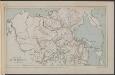
Map of the Amur Region
Russland Sibirien Amur Philip, George ; Philip, [Sohn v. G.]