Maps of Europe

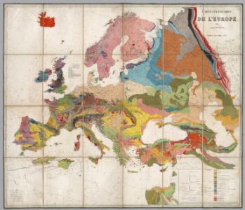
Carte Geologique De L'Europe.
1 : 3800000 Dumont, Andre
Der europäische Kontinent
1 : 7500000 Evropa Verlagsanstalt List und von Bressensdorf
Der europäische Raum
1 : 6000000 Afrika severní Richard Schwarz, Landkarten-Handlung und Geogr. Verlag
Europe.
1 : 21542400 Lucas, Fielding Jr.
Europe : laid down from the observations of the Royal Academy of Sciences & compared with the maps of Sanson, Nolin, Du Fer, De l'Isle, Moll & other modern geographers ... / [John Bowles] ; engrav'd by Emanuel Bowen
1 : 4500000 Annotatie: Met tabel van Europese lengtematen; Met informatie over de verschillende Europese staten Bowles, John; Bowen, Emanuel London : printed for John Bowles
Europa Übersicht der politischen Verhältnisse und Hauptverkehrswege
1 : 20000000 Europa Verkehrsnetz
Europa ad magnae Europae Gerardi Mercatoris P. imitationem [...] [Karte], in: Gerardi Mercatoris Atlas, sive, Cosmographicae meditationes de fabrica mundi et fabricati figura, S. 61.
1 Karte aus Atlas Mercator, Gerhard Montanus, Petrus
Europa zur Uebersicht der Flussgebiete und Höhenzüge
Hand-Atlas über alle Theile der Erde nach dem neuesten Zustande und über das Weltgebäude Stieler, Adolf bei Justus Perthes
Europa.
1 : 38000000 Flemming, Carl
Europam, Sive Celticam Veterem [Karte], in: Theatrum orbis terrarum, S. 453.
1 Karte aus Atlas Ortelius, Abraham Vrients, Jan Baptista
Europa Exactissime Descripta [Karte], in: Novus atlas absolutissimus, Bd. 1, S. 25.
1 Karte aus Atlas Janssonius Offizin
Europa. Staaten
1 : 24000000 Europa Politische Geografie
Europa
[Allgemeiner Atlas über alle Theile der Erde in 29 Blättern] Ziegler, Jakob Melchior Top. Anstalt v. J. Wurster u. Comp.
Karte von Europa und dem Mittelländischen Meere
1 : 4300000 Evropa Stülpnagel, Friedrich von Bär, Johann Christoph Justus Perthes
Karte von Europa und dem Mittelländischen Meere
1 : 4300000 Evropa Stülpnagel, Friedrich von Bär, Johann Christoph Justus Perthes
Europa
Geographischer Atlas über alle Theile der Erde Ziegler, Jakob Melchior Verlag von Dietrich Reimer
Europa
1 : 12000000 Evropa Kiepert, Heinrich Bishoff, C. Geographische Verlagshandlung Dietrich Reimer
Völkerkarte von Europa
1 : 36000000 Europa Ethnische Gruppe
Machtverhältnisse der Europ. Staaten
1 : 14000000 Übersichtskarte Block, Maurice Justus Perthes
Europe d'apres les derniers traites de paix.
1 : 12400000 Picquet, C.
Europa Exactissime Descripta [Karte], in: Gerardi Mercatoris et I. Hondii Newer Atlas, oder, Grosses Weltbuch, Bd. 1, S. 30.
1 Karte aus Atlas Mercator, Gerhard und Hondius, Jodocus Jansson, Jan
Carte demonstrative des determinations astronomiques de latitude et d'azimuth
1 : 10000000 Institut topographique militaire
Europa
Atlas der Geologie Zittel, K.v. ; Berghaus, Hermann Justus Perthes
Evropa
1 : 6000000 Evropa Melantrich
Neue Carte von Europa
1 Karte : Kupferdruck ; 42 x 49 cm, Blattgrösse 55 x 73 cm Crome; Ausfeld s.n.
Neue Karte von Europa
1 Karte : Kupferdruck ; 43 x 50 cm, Bildgrösse 55 x 71 cm Crome; Schrämbl; Adam zu finden in eigenem Verlage Schrämbl
Neue Carte von Europa
1 Karte : Kupferdruck ; 43 x 50 cm, Bildgrösse 54 x 71 cm Crome; Pingeling; Oeser; Geyser s.n.
Europa
1 Karte : Kupferdruck ; 47 x 57 cm L'Isle; Lotter; Lotter prostat nunc in officina Tobiæ Conr. Lotter geogr. et chalcogr
L'Europe
1 Karte : Kupferdruck ; 44 x 56 cm L'Isle; Fricx; Harrewijn chéz l'auteur sur le quai de l'Horloge a l'aigle d'or, chez E. H. Fricx rue de la Magdelaine
L'Europe
1 Karte : Kupferdruck ; 44 x 57 cm L'Isle; Ottens; Ottens chéz R. et J. Ottens geogrâphes dans le Kalverstraat au carte du monde
Europa
1 Karte : Kupferdruck ; 44 x 56 cm L'Isle; Wolff prostat nunc in officina Ieremiæ Wolfii