Maps of Maine

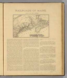
Maine Central Railroad.
1 : 4200000 New England Railway Publishing Co.
The district of Main : from the latest surveys
1 : 2900000 Carleton, Osgood, 1742-1816
The district of Main : from the latest surveys
1 : 2800000 Carleton, Osgood, 1742-1816 by Isaiah Thomas and Ebenezer T. Andrews
A map of the district of Maine : drawn from the latest surveys and other best authorities
1 : 1170000 Carleton, Osgood, 1742-1816 Thomas & Andrews
Carte de l'Acadie, Isle Royale, et Païs Voisins
1 : 2250000
County map of the State of Maine ; Portland Harbor and vicinity [inset].
from New general atlas.
Schonberg's Map of Maine and New Brunswick.
1 : 1900000 Schonberg & Co.
New Brunswick, Nova Scotia, and Prince Edward Island.
1 : 1730000 Rand McNally and Company
State Of Maine With The Province Of New Brunswick.
1 : 570240 Greenleaf, Moses, 1777-1834
Maritime Provinces.
1 : 1711000 Rand McNally and Company
Colton's railroad & township map of the state of Maine, with portions of New Hampshire, New Brunswick & Canada
1 : 550000 J.H. Colton & Co J.H. Colton & Co.
New Brunswick, Nova Scotia and Prince Edward Island.
1 : 1730000 Rand McNally and Company
Maine
1 : 1020000 Sotzmann, D. F Bey Carl Ernst Bohn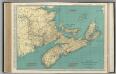
Nova Scotia, New Brunswick, and Prince Edward Island.
1 : 1140000 Rand McNally and Company
Nova Scotia, New Brunswick, and Prince Edward Island. Quebec.
1 : 1916000 Hammond, C.S.
Maritime Provinces of Canada.
1 : 1700000 Rand McNally and Company
Nova Scotia, New Brunswick, and Prince Edward Island.
Rand McNally and Company
Maine, New Brunswick, with portions of Quebec and Nova Scotia.
1 : 1265000 Asher & Adams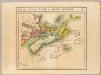
Nlle. Ecosse et Nouv. Brunswick. Amer. Sep. 44.
1 : 1641836 Vandermaelen, Philippe, 1795-1869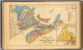
Geological map, Maritime Provinces.
1 : 1584000 Roe Brothers (Firm)
Maine, N.B.
1 : 1267200 Asher & Adams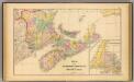
Maritime Provinces.
1 : 1584000 Roe Brothers (Firm)
Quebec, New Brunswick, Maine, Vermont, New Hampshire.
1 : 1584000 Smith, J. Calvin
Maine

Maine.
1 : 2000000 Finley, Anthony
Maine.
1 : 1550000 Tanner, Henry S.
Maine.
1 : 1550000 Mitchell, Samuel Augustus
Maine.
1 : 1550000 Mitchell, Samuel Augustus
State of Maine.
1 : 316800 Chace, J.