Maps of Europe

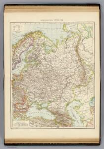
European Russia.
1 : 8700000 Andree, Richard; Times (London, England)
Europaisches Russland.
1 : 8700000 Andree, Richard
Composite: Russia, Finland.
1 : 6000000 John Bartholomew and Son
Russie et Pays Scandinaves.
1 : 960000 Jouvet et Cie.
Russie d'Europe.
1 : 7800000 Lapie, M. (Pierre), 1779-1850
Russie, Pologne.
1 : 9000000 Andriveau-Goujon, J.

Russia cum confiniis. [Karte] Russiae Pars Amphicata [Nebenkarte], in: Atlas, sive, Cosmographicae meditationes de fabrica mundi et fabricati figura, S. 153.
1 Karte aus Atlas Mercator, Gerhard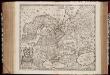
Novissima Russiæ tabula / authore Isaaco Massa
1 : 8500000 Annotatie: Rechtsboven genummerd: VI; Met opdracht van Hondius aan Isaac Bernart; Origineel is Blad 135 in atlas factice; Annotatie geografische gegevens: Met 2 schaalstokken Isaac Abrahamszoon Massa 1586-1643; Henricus Hondius 1573-1650 [Amsterdam, Londen : apud Janssonio-Waesbergios, et Mosem Pitt]
Russia cum confiniis. [Karte] Russiae Pars Amphlificata [Nebenkarte], in: Gerardi Mercatoris Atlas, sive, Cosmographicae meditationes de fabrica mundi et fabricati figura, S. 158.
1 Karte aus Atlas Mercator, Gerhard Montanus, Petrus
Mapa slovanského světa
Moscoviae seu Russiae magnae generalis tabula quâ Lapponia, Norvegia, Suecia, Dania, Polonia / de n
1 : 9100000 1 Karte : Kupferdruck ; 40 x 51 cm Visscher, Nicolaes [Nicolaes Visscher]
Mapa slovanského světa

66-67. Russia.
1 : 7500000 Touring club italiano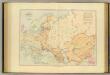
Acquisitions of Russia in Europe, Central Asia.
1 : 9800000 Stanford, Edward
Etnografska karta na slavjanstvoto v Evropa
1 : 5000000 Evropa východní Florinskij, Timofej Dmitrijevič Slavjanska besěda
A map of Russia / [John Speed] ; F. Lamb sculp
1 : 7454000 1 Karte : Kupferdruck ; 39 x 49 cm Speed, John Sold by Tho. Basset in Fleetstreet and Richard Chiswell in St. Pauls Church yard
Mapa slovanského světa

Volkerkarte von Russland.
1 : 13300000 Andree, Richard
Russland und Skandinavien
Hand-Atlas über alle Theile der Erde und über das Weltgebäude Stieler, Adolf Justus Perthes

Russland Und Skandinavien.
1 : 10000000 Petermann, A.
Soubor němých map pro gymnasia a odborné školy

Russland und Skandinavien
Adolf Stieler's Handatlas über alle Theile der Erde und über das Weltgebäude Stieler, Adolf Justus Perthes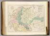
Sketch of the Acquisitions of Russia since the Accession of Peter 1st. to the Throne.
1 : 6969600 Arrowsmith, John
Novissima Russiæ tabula / authore Isaaco Massa
1 : 840000 1 Karte : Kupferdruck ; 46 x 54 cm Massa, Isaac Abrahamsz Hen. Hondius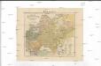
Mapa slovanského světa
1 : 10000000 Evropa Erben, Josef Šafařík, Pavel Josef nákladem Matice lidu
Mapa slovanského světa
Evropa Erben, Josef Šafařík, Pavel Josef nákladem Matice lidu
Mapa slovanského světa
1 : 10000000 Evropa Erben, Josef Šafařík, Pavel Josef nákladem Matice lidu
Mapa slovanského světa
Evropa Erben, Josef Šafařík, Pavel Josef nákladem Matice lidu