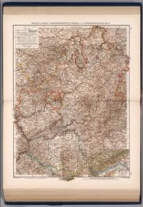
Maps of Baden-Württemberg

Hessen-Nassau, Groszherzogtum Hessen und Furstentum Waldeck
1 : 500000 Scobel, Albert
Neueste Karte von Württemberg, Baden, Hohenzollern, die Rheinpfalz nebst den deutschen Reichslanden Elsass und Lothringen : zum Hand- und Comptoir-Gebrauch bearbeitet und namentlich mit Rücksicht auf Eisenbahnen als Reise- und Verkehrskarte angelegt
Baur, Carl Friedrich Wittwer
Sveviae utriusque cum Germanicæ tum Rheticæ celebratissimis vrbibus
1 Karte : Kupferdruck ; 20 x 22 cm, Bildgrösse 21 x 29 cm Seltzlin; Quad; Bussemacher excudit Johan Buchsemecher
Landgraviatus Alsatiae
1 : 340000 Alsasko (Francie) Homann, Johann Baptist Ioh. Baptista Homanno
Landgraviatus Alsatiae
1 : 340000 Alsasko (Francie) Homann, Johann Baptist J. B. Homann
Landgraviatus Alsatiae
1 : 340000 Alsasko (Francie) Homann, Johann Baptist Ioh. Baptista Homanno
Circulus Suevicus in quo sunt ducatus Wirtenbergensis
1 Karte : Kupferdruck ; 46 x 55 cm Bodenehr s.n.
Länder in Südwestdeutschland 1947
Land Baden, Württemberg-Hohenzollern Kunz, Andreas ; Treiling, Thomas ; Moeschl, Joachim
[Southwest Germany]
1 : 1400000 [S.l. : s.n.]
Abriss des Reinstroms
1 : 870000 Mollova mapová sbírka
Charte von dem Königreiche Wirtemberg und dem Grossherzogthume Baaden


Circulus Suevicus in quo Ducatus Wirtenbergensis cum reliquis Statibus Et Provinciis curate designatus proponitur
Seutter, Matthäus Seutter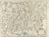
Palatinat du Rhein, Alsace, et Partie de Souabe de Franconie &c.
1 : 870000 Mollova mapová sbírka Sanson, Nicolas Cordier, Robert Sanson, Nicolas
Circulus Svevicus
1 Karte : Kupferdruck ; 46 x 65 cm Kraus; Wagner; Wille sumtibus Matthæi Wagner
Circolo di Svevia diviso ne suoi stati
1 Karte : Kupferdruck ; 31 x 40 cm Zatta; Zuliani; Pitteri presso Antonio Zatta
Das Kœnigreich Würtemberg nebst dem Grosherzogthum Baaden, den Fürstenthümern Hohenzollern und Layen
1 Karte : Kupferdruck ; 59 x 53 cm Pflummern in A. G. Schneider u: Weigels kön: priv: Kunst u: Landkartenhandlung
Tractvs Rhenanvs Svperior
1 : 810000 Mollova mapová sbírka Weigel, Christoph I. - vdova
Charte über das Grossherzogthum Baden
1 Karte : Kupferdruck ; 61 x 38 cm Tulla; Müller; Hutter verlegt bei C. F. Müller Hofbuchdrucker
S.R.I. Sueviae Circulus atq. Ducatus una cum Insertis et Adjacentibus Regionibus, accuratissime in earundem particulares Provincias divisum
1 : 620000 Mollova mapová sbírka Visscher, Nicolaes Schenk, Peter II
[Charte vom Königreich Würtemberg, und dem Grossherzogthum Baden]
Neuester Schul-Atlas Walch, Johann im Verlag bei Joh. Walch
Grossherzogthum Baden
1 : 824000 Bádensko (Německo) Martin Gleditsch
Circulus Suevicus in quo sunt ducatus Wirtenbergensis
1 Karte : Kupferdruck ; 48 x 57 cm Danckerts Theodorus Danckerts
Circulus Suevicus
1 : 590000 1 Karte : Kupferdruck ; 49 x 57 cm Danckerts, Theodorus [Danckerts]
Baden.
1 : 800000 Radefeld, Carl Christian Franz, 1788-1874
Wurtemberg, Baden.
1 : 450000 Weiland, C. F. (Carl Ferdinand), d. 1847
Geognostische Karte von Württemberg, Baden und Hohenzollern
1 : 700000 Bach, Carl Philipp Heinrich Verlag der G. Ebner'schen Kunsthandlung
Cours du Danube feuille I contenant la Suabe ou est exactement marquée la succession de Charles VI
1 Karte : Kupferdruck ; 47 x 55 cm Le Rouge chez le Rouge rue des Augustins vis a vis le Panier Fleuri
Grand theatre de la guerre sur les frontieres de France & d' Allemagne ou carte nouvelle du cours du Rhin et des pais circonvoisins contenant la Haute & Basse Alsace & le Palatinat & les electorats de Mayence, de Treves & une partie de Cologne de Hesse, de Franconie, de Baviere, le cercle de Souable le duché de Wurtenberg, de Brisgaw, de Bade, de Suntgaw & c. & c. & c
Francie Delisle, Guillaume Jean Covens & Corneille Mortier