Maps of Delta Amacuro

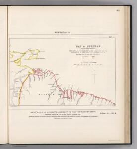
Facsimile: Surinam by Popple.
1 : 3787000 Popple, Henry
Boundaries Claimed or Proposed.
1 : 2027520 Venezuela-British Guiana Boundary Commission
European Occupation in 1803 (1814).
1 : 2027520 Venezuela-British Guiana Boundary Commission
European Occupation in 1796.
1 : 2027520 Venezuela-British Guiana Boundary Commission
European Occupation in 1674.
1 : 2027520 Venezuela-British Guiana Boundary Commission
European Occupation in 1626.
1 : 2027520 Venezuela-British Guiana Boundary Commission
European Occupation in 1597.
1 : 2027520 Venezuela-British Guiana Boundary Commission
European Occupation in 1724.
1 : 2027520 Venezuela-British Guiana Boundary Commission
European Occupation in 1756.
1 : 2027520 Venezuela-British Guiana Boundary Commission
Grand View of European Occupation, 1597-1803 (1814).
1 : 2027520 Venezuela-British Guiana Boundary Commission
European Occupation in 1773.
1 : 2027520 Venezuela-British Guiana Boundary Commission
European Occupation in 1648.
1 : 2027520 Venezuela-British Guiana Boundary Commission
Facsimile: Guiana by Blaeuw.
1 : 7100000 Blaeuw, William
De kusten van Gujana in Westindia van Suriname tot Rio Oronoque, waerin tussen Cossewijne en Corretijne de riv. van Inikelke legt die bij ons onbekent was en in mijn groote caert van Suriname moet geteekent worden; voor de rest is omtrent de strekking van de riviere goede aenmerkingh
Suriname Gerard van Keulen
Forests and Savannas.
1 : 2027520 Venezuela-British Guiana Boundary Commission
Drainage Basins.
1 : 2027520 Venezuela-British Guiana Boundary Commission
European Occupation in 1703.
1 : 2027520 Venezuela-British Guiana Boundary Commission
De kust van Guijana tussen R. Cupanama en Rio Oronoque
Guyana Gerard van Keulen
Partie, Colombie. Amer. Merid. 3.
1 : 1641836 Vandermaelen, Philippe, 1795-1869
Facsimile: Part of South America by Arrowsmith.
1 : 2800000 Arrowsmith, John
Carta del Canton de Upata, Provincia de Guayana.
1 : 1300000 Codazzi, Agustin, 1793-1859
Facsimile: Part of Chart of the Guiana Coast by Jefferys.
1 : 1510000 Jefferys, Thomas
A new chart of the coast of Guyana from Rio Orinoco to River Berbice.
1 : 550000 Jefferys, Thomas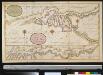
De rivier van Oronoque van Moco Moco tot St. Thome en een gedeelte van de Golf van Paria
Venezuela Gerard van Keulen
Facsimile: Part of the Great Colonial Map by Schomburgk.
1 : 1430000 Brown, Charles B.
Facsimile: Chart of Guiana by Raleigh.
Raleigh, Walter
Facsimile: Jesuit Missions of New Granada by Gumilla.
1 : 10300000 Gumilla, Joseph
Coast Region of the Essequibo Colony by Chollet(?).
Chollet, L.
Facsimile: Part of Northern Coast of South America by Jefferys.
1 : 1540000 Jefferys, Thomas