Maps of Negaunee Township
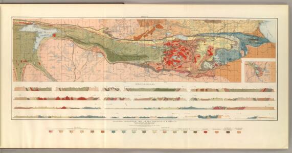
General Geological Map of the Marquette District.
1 : 63360 Van Hise, C.
Atlas to accompany monograph XXVIII on the Marquette iron-bearing district of Michigan
1 : 630000 Sheet 4 Van Hise, Charles Richard United States Geological Survey
Witch Lake NE
1 : 24000
Witch Lake NE
1 : 24000
Republic
1 : 24000
Republic
1 : 24000
Greenwood
1 : 24000
Ishpeming
1 : 24000
Ishpeming
1 : 24000
Palmer
1 : 24000
Palmer
1 : 24000
Sands
1 : 24000
Sands
1 : 24000
Sands
1 : 24000
Harvey NW
1 : 31680
Detailed Geology Sheet XXXVIII.
1 : 13200 Van Hise, C.
Atlas to accompany monograph XXVIII on the Marquette iron-bearing district of Michigan
1 : 630000 Sheet 26 Van Hise, Charles Richard United States Geological Survey
Atlas to accompany monograph XXVIII on the Marquette iron-bearing district of Michigan
1 : 630000 Sheet 39 Van Hise, Charles Richard United States Geological Survey
Atlas to accompany monograph XXVIII on the Marquette iron-bearing district of Michigan
1 : 630000 Sheet 14 Van Hise, Charles Richard United States Geological Survey
Atlas to accompany monograph XXVIII on the Marquette iron-bearing district of Michigan
1 : 630000 Sheet 32 Van Hise, Charles Richard United States Geological Survey
Atlas to accompany monograph XXVIII on the Marquette iron-bearing district of Michigan
1 : 630000 Sheet 36 Van Hise, Charles Richard United States Geological Survey
Detailed Geology Sheet VIII.
1 : 13200 Van Hise, C.
Atlas to accompany monograph XXVIII on the Marquette iron-bearing district of Michigan
1 : 630000 Sheet 19 Van Hise, Charles Richard United States Geological Survey
Atlas to accompany monograph XXVIII on the Marquette iron-bearing district of Michigan
1 : 630000 Sheet 16 Van Hise, Charles Richard United States Geological Survey
Atlas to accompany monograph XXVIII on the Marquette iron-bearing district of Michigan
1 : 630000 Sheet 25 Van Hise, Charles Richard United States Geological Survey
Atlas to accompany monograph XXVIII on the Marquette iron-bearing district of Michigan
1 : 630000 Sheet 28 Van Hise, Charles Richard United States Geological Survey
Atlas to accompany monograph XXVIII on the Marquette iron-bearing district of Michigan
1 : 630000 Sheet 13 Van Hise, Charles Richard United States Geological Survey
Atlas to accompany monograph XXVIII on the Marquette iron-bearing district of Michigan
1 : 630000 Sheet 15 Van Hise, Charles Richard United States Geological Survey
Atlas to accompany monograph XXVIII on the Marquette iron-bearing district of Michigan
1 : 630000 Sheet 30 Van Hise, Charles Richard United States Geological Survey