Maps of West Indies
West Indies.
1 : 7900000 Thomson, John
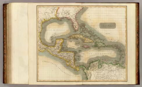
West Indies.
1 : 17500000 Arrowsmith, Aaron; Lewis, Samuel
West Indies.
1 : 17500000 Arrowsmith, Aaron; Lewis, Samuel
Carte du Golfe du Mexique et des Isles Antilles
1 : 10168000
[West-Indien und Centro-America, nebst dem Meerbusen von Mexico]
Schul-Atlas über alle Theile der Erde nach dem neuesten Zustande, und über das Weltgebäude Stieler, Adolf Justus Perthes
INSULAE AMERICANAE in Oceano Septentrionalis ac REGIONES ADIACENTES
1 : 10300000 Karibská oblast Visscher, Nicolaes Jansz. per Nicolaum Visscher
Iles-Antilles ou Indes Occidentales.
1 : 9300000 Brue, Adrien Hubert, 1786-1832
West India Isles.
1 : 9100000 Cary, John, ca. 1754-1835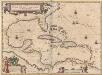
Insulae Americanae In Oceano Septentrionali, cum Terris adiacentibus. [Karte], in: Novus Atlas, das ist, Weltbeschreibung, Bd. 2, S. 311.
1 Karte aus Atlas Blaeu, Joan Blaeu, Willem Janszoon
215-216. Central America and West Indies. The World Atlas.
1 : 7500000 USSR (Union of Soviet Socialist Republics).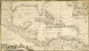
A NEW MAPP of the WEST INDIES, or the ISLANDS of AMERICA in the NORTH SEA; Together with the adjacent DOMINIONS; Explaining what belongs to SPAIN, ENGLAND, FRANCE, HOLLAND &C. As also the severall Tracts made by the Gallions and Flota from place to place,
This interesting map published in 1740 is a later edition of one published by Robert Morden, William Knight and Philip Lea. The colonising powers are indicated in words but colouring is mainly for decoration. Notes give an idea of shipping routes and practices, and in the Gulf of Mexico the number of fathoms in depth are said to be equal to the distance in leagues from the coast! The sketch at bottom left which forms part of the title cartouche shows a group of sailors presenting a pair of shoes to a native in exchange for a chest of gold coins. Morden, Robert. Cartographer.
Mittel-America und Westindien
1 : 8000000
The West Indies and coast adjacent, reduced from the sheet map
1 : 16663680
Mittel-America und Westindien
Neuer Handatlas über alle Theile der Erde Kiepert, Heinrich Verlag von Dietrich Reimer
[West-Indien und Centro-America, nebst dem Meerbusen von Mexico]
Schul-Atlas über alle Theile der Erde nach dem neuesten Zustande, und über das Weltgebäude Stieler, Adolf bei Justus Perthes
West India islands
1 : 1
[Central-Amerika und Westindien]
Geographischer Atlas über alle Theile der Erde Ziegler, Jakob Melchior Verlag von Dietrich Reimer
Texas, der Mexicanische Bundesstaat, der Mittelamericanische Bundesstaat, und West Indien
Schul-Atlas in 36 Karten Völter, Daniel Verlag der J.M. Dannheimer'schen Buchhandlung
West India Islands.
1 : 14500000 Darton, William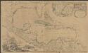
Archipelague du Mexique ou sont les Isles de Cuba, Espagnole, Jamaïque &c.
1 : 5000000 [par Pierre Mortier] A Amsterdam : nouvellement mis au jour par Covens & Mortier
Insulae Americanae in Oceano Septentrionali ac regiones adiacentes, a C. de May usque ad Lineam Aequinoctialem
1 : 9936000
Insulae Americanae in Oceano Septentrionali ac regiones adjacentes a C. de May usque ad Lineam Aequinoctialem
1 : 10000000 per Nicolaum Visscher [Amsterdam] : nunc apud Petrum Schenk Junior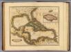
West India Islands.
1 : 13400000 Lizars, Daniel
Insulae Americanae In Oceano Septentrionali, cum Terris adiacentibus. [Karte], in: Gerardi Mercatoris et I. Hondii Newer Atlas, oder, Grosses Weltbuch, Bd. 2, S. 379.
1 Karte aus Atlas Mercator, Gerhard und Hondius, Jodocus Jansson, Jan
Insulae Americanae in Oceano Septentrionali cum terris adiacentibus
1 : 10000000 Blaeu, Willem Janszoon, 1571-1638 G. Blaeu
Insulae Americanae in Oceano Septentrionali ac REGIONES ADIACENTES, a C. de May usque ad Lineam Aequinoctialem
This early 18th century map of the West Indies was produced by Nicolaes Visscher II who was the grandson of celebrated Dutch map maker Claes Jansz Visscher. It was originally published in c.1690 in his Atlas Minor but this is a reprint of c.1717 by Pieter Schenk. It is a typical elaborately decorated Dutch map and the colouring of the islands is decorative as opposed to functional. Visscher, Nicholaum. Cartographer.
[144][147] Indiarum Occidentalium Tractus Littorales cum Insulis Caribicis ..., uit: Atlas sive Descriptio terrarum orbis
Annotatie: Gedigitaliseerde versie. Amsterdam. Heiloo : Picturae (vervaardiger), 2015. tiff-bestand. Gedigitaliseerd: 07-01-2015; Origineel: Universiteitsbibliotheek Vrije Universiteit (XL.05127.-) ; Netherlands; Titelpagina ontbreekt Wit, Frederik de Amsterdam : Frederick de Wit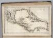
West Indies.
1 : 12500000 Carey, Mathew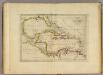
Chart of the West Indies.
1 : 11750000 Carey, Mathew
Chart of the West Indies.
1 : 11750000 Carey, Mathew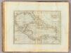
Chart of the West Indies.
1 : 11750000 Carey, Mathew
Chart of the West Indies.
1 : 11000000 Carey, Mathew