Maps of Metropolitan France

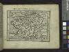
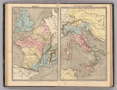
Gaule, Italie Ancienne.
Andriveau-Goujon, J.
[Ethnographische Karte von Europa]
Zweiter Band, enthaltend in vier Abtheilungen die Vertheilung der Organismen: 5. Pflanzen-Geographie, 6. Thier-Geographie, 7. Anthropographie, 8. Ethnographie Humboldt, Alexander von Verlag von Justus Perthes
Carte des routes de postes de l'Empire francais du royaume d'Italie et de la Confédération du Rhin
Evropa západní Tardieu, Pierre François
Západní Evropa při konci XIV. věku
Imper. Caroli Magni.
1 : 5000000 Robert de Vaugondy, Gilles, 1688-1766
Stannard & Son's, panoramic birds-eye view of France & Prussia and the surrounding countries likely to be involved in the War, with the railways & startegic positions of each army, & the great fortresses of the Rhine provinces
1 : 1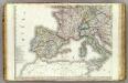
Europe 3.
1 : 3850000 Brue, Adrien Hubert, 1786-1832
Karte von Europa, 3
4 Blätter : 53 x 70 cm Verlag der Königlich-Preussischen Academie-Kunst- und Buchhandlung
West- u. Mittel- Europa im Zeitalter Napoleons (bis 1810)
Evropa střední F. Tempsky
[Europa's Haupt-Gebirgs-Systeme]
Erster Band, enthaltend in vier Abtheilungen die Erscheinungen der anorganischen Natur: 1. Meteorologie und Klimatographie. 2. Hydrologie und Hydrographie. 3. Geologie. 4. Tellurischer Magnetismus Humboldt, Alexander von Verlag von Justus Perthes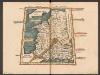
Tercia Europe Tabula [Gallia] [Karte], in: Claudii Ptolemei viri Alexandrini mathematice discipline philosophi doctissimi geographie opus [...], S. 157.
1 Karte aus Atlas Waldseemüller, Martin [und Ptolemaeus, Claudius] Übelin, Georg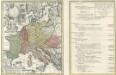
Tab. IV. Imperii Francici vel Romano German S. Romani Occid.
1 : 8500000 Mollova mapová sbírka Homann, Johann Baptist Homann, Johann Baptista - dědici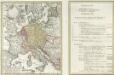
Tab. IV. Imperii Francici vel Romano-German. S. Romani Occid.
1 : 8500000 Mollova mapová sbírka Homann, Johann Baptist Homann, Johann Baptista - dědici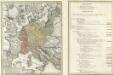
Tab. IV. Imperii Francici vel Romano-German. S. Romani Occid.
1 : 8500000 Mollova mapová sbírka Homann, Johann Baptist Homann, Johann Baptista - dědici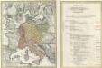
Tab. IV. Imperii Francici vel Romano-German. S. Romani Occid.
1 : 8500000 Mollova mapová sbírka Homann, Johann Baptist Homann, Johann Baptista - dědici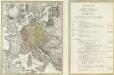
Tab. IV. Imperii Francici vel Romano-German. S. Romani Occid.
1 : 8500000 Mollova mapová sbírka Homann, Johann Baptist Homann, Johann Baptista - dědici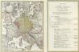
Tab. IV. Imperii Francici vel Romano-German. S. Romani Occid.
1 : 8500000 Mollova mapová sbírka Homann, Johann Baptist Homann, Johann Baptista - dědici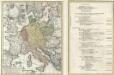
Tab. IV. Imperii Francici vel Romano-German. S. Romani Occid.
1 : 8500000 Mollova mapová sbírka Homann, Johann Baptist Homann, Johann Baptista - dědici
Die Zeit der ersten franz. Republik
Frankreich, Deutschland, Französische Revolution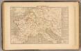
Demembrement de l'Empre. de Charlemagne.
1 : 5800000 Houze, Antoine Philippe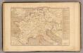
L'Empre. de Charlemagne de 768 a 814.
1 : 5800000 Houze, Antoine Philippe
France, Spain, Portugal, Italy.
1 : 9200000 Mitchell, Samuel Augustus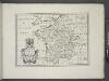
France, and parts adjoining.
from A new sett of maps both of antient and present geography : wherein not only the latitude and longitude of many places are corrected according to the latest observations, but also the most remarkable differences of antient and present geography may be quickly discern'd by a bare inspection or comparing of correspondent maps, which seems to be the most natural and easy method to lead young students (for whose use the work is principally intended) unto a competent knowledge of the geographical science : together with a geographical treatise particularly adapted to the use and design of these maps / by Edward Wells, M.A. and student of Christ-Church, Oxon.
Imperivm Francicvm vel Romanvm Occidentale Posterivs sub ipso Carolo Magno
1 : 28000000 Mollova mapová sbírka Homann, Johann Baptist Homann, Johann Baptista - dědici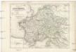
Die Reiche der Carolinger
1 : 8400000 Evropa západní
Tabula Europae III. [Karte], in: Claud. Ptolemaeus. Geographia lat. cum mappis [...], S. 260.
1 Karte aus Atlas Münster, Sebastian [und Ptolemaeus, Claudius]
Die Republik und das Kaiserthum Frankreich mit seinen Bundes-Staaten.
1 : 5200000 Spruner von Merz, Karl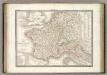
France 1789, 1813.
1 : 3700000 Lapie, M. (Pierre), 1779-1850
Jak vzniká mapa